
Seller's Agent in 2025
Teresa Dudzikowski
Coldwell Banker Realty
(203) 233-3217
2 in this area
58 Total Sales
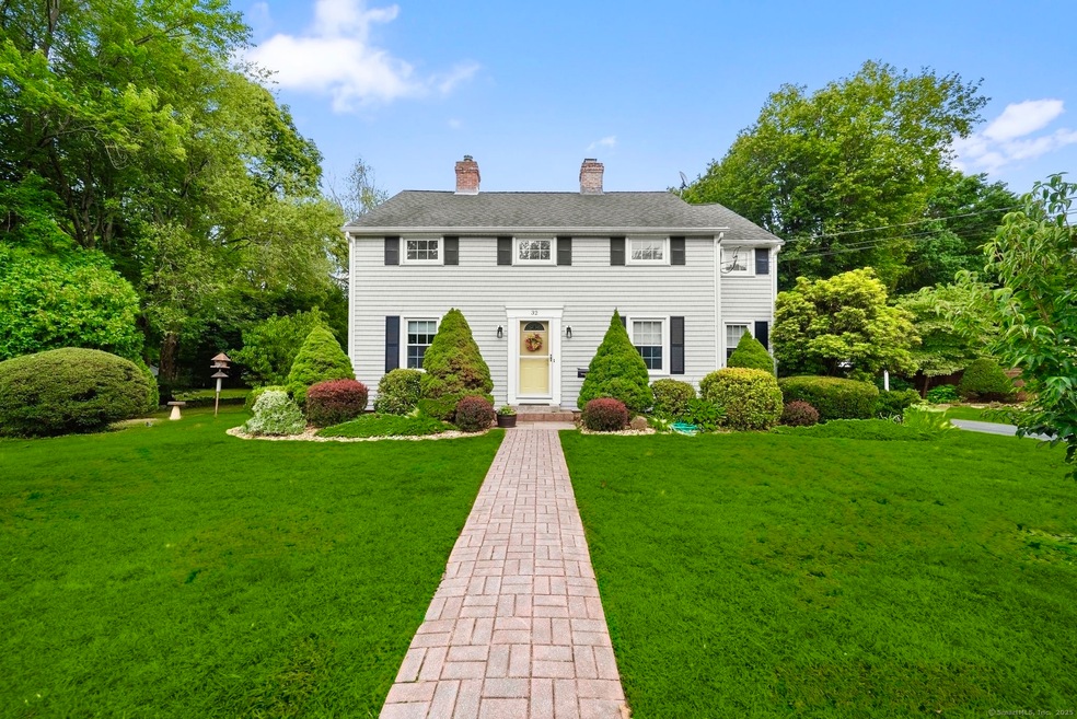
PICTURE YOURSELF COMING HOME TO THIS METICULOUSLY MAINTAINED AND PICTURESQUE COLONIAL-STYLE HOME JUST 400 YARDS FROM INDIAN HILL COUNTRY CLUB! A custom brick walkway enhances the home's charming curb appeal. Inside you'll find a warm & inviting interior featuring: A spacious formal dining room w/bay windows. A cozy family room w/a warm & welcoming wood-burning fireplace. An expansive open-concept Great Room/eat-in kitchen. The Great Room (2008) impresses w/SOARING 14+ ft cathedral ceilings, elegant exposed beams, stunning Enviro pellet stove fireplace (Vancouver Island, BC), skylights, stylish crown molding w/cove lighting, beautiful built-ins & bookcases, custom built concealed TV cabinet, & stylish American made Runtal heating radiators (oil fueled). A thoughtfully designed kitchen offers abundant cabinetry, generous granite countertop space, a mahogany breakfast bar, a dry bar, a large island w/electric cooktop, & built-in wall oven, perfect for the culinary enthusiast! From the Great Room, French doors open to a durable Veranda composite deck (2008), overlooking a private/tranquil backyard, adorned w/perennial gardens, fruit trees (apple & nectarine) & the perfect setting to sip coffee in the morning or stargaze in the evening. Flexible floor plan: MAIN LEVEL BEDROOM for added convenience. 3 additional bedrooms upstairs, including full bath w/soaking tub. Walk-in bedroom closet(12'2"X 8'). Desirable hardwood floors throughout, abundant natural light entering CONTINUED...
Last Agent to Sell the Property
Coldwell Banker Realty Brokerage Phone: (203) 233-3217 License #RES.0803991 Listed on: 08/22/2025
| Date | Type | Sale Price | Title Company |
|---|---|---|---|
| Deed | $520,000 | -- | |
| Quit Claim Deed | -- | None Available | |
| Executors Deed | $128,000 | -- |
| Date | Status | Loan Amount | Loan Type |
|---|---|---|---|
| Open | $468,000 | Purchase Money Mortgage | |
| Previous Owner | $138,500 | No Value Available | |
| Previous Owner | $87,500 | No Value Available | |
| Previous Owner | $89,000 | No Value Available | |
| Previous Owner | $93,000 | Purchase Money Mortgage |
| Date | Event | Price | List to Sale | Price per Sq Ft |
|---|---|---|---|---|
| 10/27/2025 10/27/25 | Sold | $520,000 | +11.9% | $232 / Sq Ft |
| 08/30/2025 08/30/25 | Pending | -- | -- | -- |
| 08/22/2025 08/22/25 | For Sale | $464,900 | -- | $208 / Sq Ft |
| Year | Tax Paid | Tax Assessment Tax Assessment Total Assessment is a certain percentage of the fair market value that is determined by local assessors to be the total taxable value of land and additions on the property. | Land | Improvement |
|---|---|---|---|---|
| 2025 | $6,490 | $162,330 | $57,880 | $104,450 |
| 2024 | $6,440 | $162,330 | $57,880 | $104,450 |
| 2023 | $5,890 | $153,540 | $57,880 | $95,660 |
| 2022 | $5,910 | $153,540 | $57,880 | $95,660 |
| 2021 | $5,959 | $153,540 | $57,880 | $95,660 |
| 2020 | $5,850 | $148,930 | $55,650 | $93,280 |
| 2019 | $5,875 | $148,930 | $55,650 | $93,280 |
| 2018 | $5,734 | $148,930 | $55,650 | $93,280 |
| 2017 | $5,449 | $148,930 | $55,650 | $93,280 |
| 2016 | $5,324 | $148,930 | $55,650 | $93,280 |
| 2014 | $5,640 | $162,210 | $55,440 | $106,770 |
Seller's Agent in 2025
Teresa Dudzikowski
Coldwell Banker Realty
(203) 233-3217
2 in this area
58 Total Sales
Buyer's Agent in 2025
Carla Presz
Verge Real Estate Group LLC
(860) 221-5314
1 in this area
35 Total Sales
Source: SmartMLS
MLS Number: 24120985
APN: NEWI-000015-000267
Disclaimer: Certain information contained herein is derived from information provided by parties other than Homes.com. All information provided is deemed reliable, but is not guaranteed to be accurate and should be independently verified.
![]() IDX information is provided exclusively for personal, non-commercial use, and may not be used for any purpose other than to identify prospective properties consumers may be interested in purchasing. Information is deemed reliable but not guaranteed.
IDX information is provided exclusively for personal, non-commercial use, and may not be used for any purpose other than to identify prospective properties consumers may be interested in purchasing. Information is deemed reliable but not guaranteed.
Ask me questions while you tour the home.