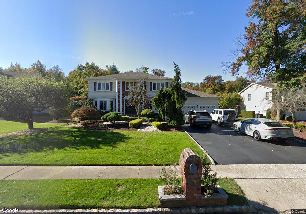
32 Westbrook Way Manalapan, NJ 07726
Estimated Value: $1,115,000 - $1,237,000
4
Beds
2
Baths
3,532
Sq Ft
$332/Sq Ft
Est. Value
About This Home
This home is located at 32 Westbrook Way, Manalapan, NJ 07726 and is currently estimated at $1,171,009, approximately $331 per square foot. 32 Westbrook Way is a home located in Monmouth County with nearby schools including Taylor Mills Elementary School, Pine Brook Elementary School, and Manalapan-Englishtown Middle School.
Ownership History
Date
Name
Owned For
Owner Type
Purchase Details
Closed on
May 22, 2008
Sold by
Gugliuzza Nicholas and Gugliuzza Phyllis
Bought by
Gambale Eugene and Gambale Elizabeth
Current Estimated Value
Home Financials for this Owner
Home Financials are based on the most recent Mortgage that was taken out on this home.
Original Mortgage
$415,000
Outstanding Balance
$263,230
Interest Rate
5.91%
Mortgage Type
Purchase Money Mortgage
Estimated Equity
$907,779
Create a Home Valuation Report for This Property
The Home Valuation Report is an in-depth analysis detailing your home's value as well as a comparison with similar homes in the area
Home Values in the Area
Average Home Value in this Area
Purchase History
| Date | Buyer | Sale Price | Title Company |
|---|---|---|---|
| Gambale Eugene | $667,500 | Stewart Title Guaranty Co |
Source: Public Records
Mortgage History
| Date | Status | Borrower | Loan Amount |
|---|---|---|---|
| Open | Gambale Eugene | $415,000 |
Source: Public Records
Tax History Compared to Growth
Tax History
| Year | Tax Paid | Tax Assessment Tax Assessment Total Assessment is a certain percentage of the fair market value that is determined by local assessors to be the total taxable value of land and additions on the property. | Land | Improvement |
|---|---|---|---|---|
| 2025 | $15,930 | $1,033,300 | $394,600 | $638,700 |
| 2024 | $15,490 | $943,700 | $394,600 | $549,100 |
| 2023 | $15,490 | $930,900 | $394,600 | $536,300 |
| 2022 | $13,780 | $840,200 | $329,600 | $510,600 |
| 2021 | $13,780 | $663,800 | $209,600 | $454,200 |
| 2020 | $13,907 | $677,400 | $187,100 | $490,300 |
| 2019 | $13,999 | $681,200 | $202,100 | $479,100 |
| 2018 | $13,516 | $653,900 | $197,100 | $456,800 |
| 2017 | $13,171 | $637,500 | $197,100 | $440,400 |
| 2016 | $13,510 | $661,600 | $226,800 | $434,800 |
| 2015 | $12,083 | $585,400 | $161,900 | $423,500 |
| 2014 | $12,387 | $584,300 | $160,000 | $424,300 |
Source: Public Records
Map
Nearby Homes
- 124 Taylors Mills Rd
- 104 Gordons Corner Rd
- 18 Cornell Place
- 37 Pease Rd
- 32 Devon Dr
- 17 Yorktowne Dr
- 6 Canterbury Rd
- 102 Blue Jay Ct
- 8 Derek Ct
- 16 Timber Ln
- 5 Mallard Ct
- 89 Old Queens Blvd
- 11 Browning Place
- 1 Princeton Dr
- 1 Thoreau Dr
- 56 Tarrytown Rd
- 11 Oxford Rd
- 21 Thoreau Dr
- 10 Milton Ave
- 32 Tarrytown Rd
- 30 Westbrook Way
- 34 Westbrook Way
- 28 Westbrook Way
- 36 Westbrook Way
- 31 Westbrook Way
- 33 Westbrook Way
- 26 Westbrook Way
- 29 Westbrook Way
- 35 Westbrook Way
- 25 Westbrook Way
- 24 Westbrook Way
- 37 Westbrook Way
- 112 Taylors Mills Rd
- 39 Westbrook Way
- 110 Taylors Mills Rd
- 23 Westbrook Way
- 114 Taylors Mills Rd
- 15 Danielle Dr
- 22 Westbrook Way
- 17 Westbrook Way