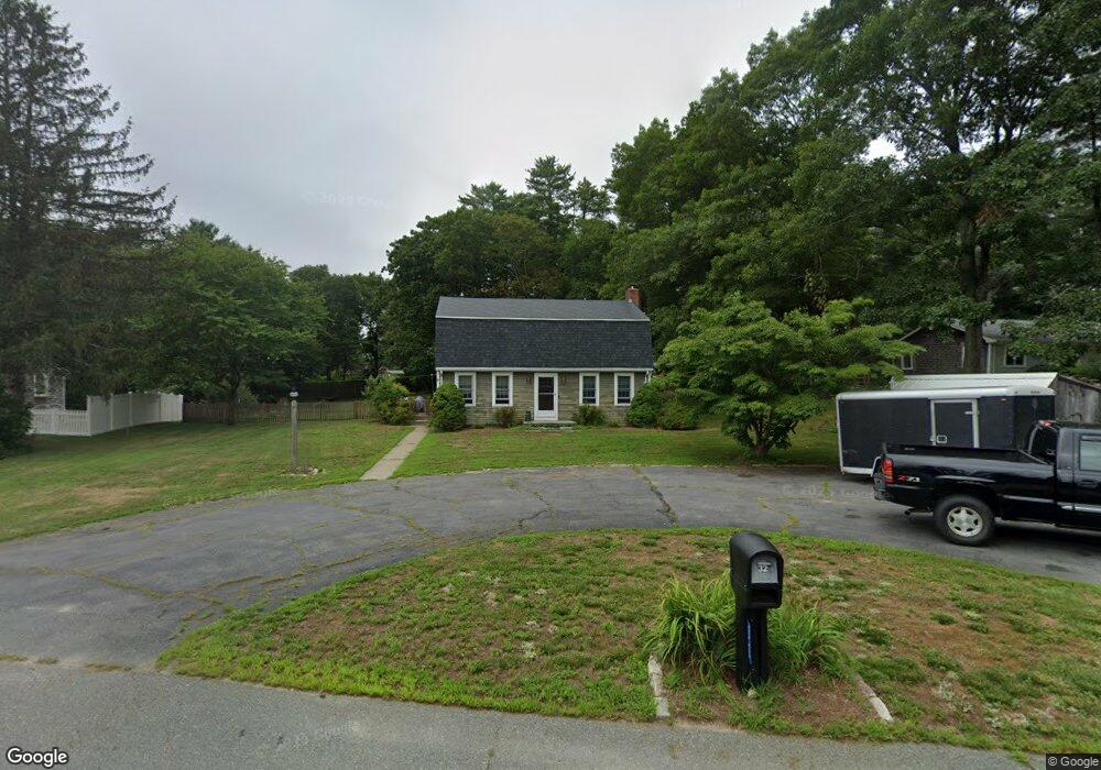
32 Winfield St East Freetown, MA 02717
Estimated Value: $539,272 - $608,000
3
Beds
2
Baths
1,618
Sq Ft
$356/Sq Ft
Est. Value
About This Home
This home is located at 32 Winfield St, East Freetown, MA 02717 and is currently estimated at $575,568, approximately $355 per square foot. 32 Winfield St is a home located in Bristol County with nearby schools including Freetown Elementary School, George R Austin Intermediate School, and Freetown-Lakeville Middle School.
Ownership History
Date
Name
Owned For
Owner Type
Purchase Details
Closed on
Sep 1, 2005
Sold by
Matteson Kathleen M
Bought by
Johnson Gilbert I and Johnson Kimberly J
Current Estimated Value
Home Financials for this Owner
Home Financials are based on the most recent Mortgage that was taken out on this home.
Original Mortgage
$283,000
Outstanding Balance
$151,025
Interest Rate
5.81%
Mortgage Type
Purchase Money Mortgage
Estimated Equity
$424,543
Purchase Details
Closed on
Dec 15, 2004
Sold by
Matteson Kathleen M
Bought by
Kathleen M Matteson Re and Matteson Kathleen M Es
Purchase Details
Closed on
May 4, 2004
Sold by
Matteson Kathleen M
Bought by
Matteson Kathleen M Life and Matteson Kristen A Rem
Create a Home Valuation Report for This Property
The Home Valuation Report is an in-depth analysis detailing your home's value as well as a comparison with similar homes in the area
Home Values in the Area
Average Home Value in this Area
Purchase History
| Date | Buyer | Sale Price | Title Company |
|---|---|---|---|
| Johnson Gilbert I | $363,000 | -- | |
| Kathleen M Matteson Re | -- | -- | |
| Matteson Kathleen M Life | -- | -- |
Source: Public Records
Mortgage History
| Date | Status | Borrower | Loan Amount |
|---|---|---|---|
| Open | Johnson Gilbert I | $283,000 | |
| Previous Owner | Matteson Kathleen M Life | $149,300 | |
| Previous Owner | Matteson Kathleen M Life | $52,000 | |
| Previous Owner | Matteson Kathleen M Life | $40,000 |
Source: Public Records
Tax History Compared to Growth
Tax History
| Year | Tax Paid | Tax Assessment Tax Assessment Total Assessment is a certain percentage of the fair market value that is determined by local assessors to be the total taxable value of land and additions on the property. | Land | Improvement |
|---|---|---|---|---|
| 2025 | $4,414 | $445,400 | $179,200 | $266,200 |
| 2024 | $4,384 | $420,300 | $169,000 | $251,300 |
| 2023 | $4,281 | $399,700 | $152,200 | $247,500 |
| 2022 | $4,081 | $338,400 | $129,000 | $209,400 |
| 2021 | $3,876 | $308,200 | $117,300 | $190,900 |
| 2020 | $3,271 | $298,700 | $112,800 | $185,900 |
| 2019 | $3,678 | $279,700 | $107,400 | $172,300 |
| 2018 | $3,040 | $261,700 | $107,400 | $154,300 |
| 2017 | $3,419 | $256,700 | $107,400 | $149,300 |
| 2016 | $3,263 | $249,300 | $104,300 | $145,000 |
| 2015 | $3,181 | $246,600 | $104,300 | $142,300 |
| 2014 | $3,072 | $243,600 | $102,200 | $141,400 |
Source: Public Records
Map
Nearby Homes
- 3 Abraham Ave
- 247 Braley Hill Rd
- 269 Middleboro Rd
- 28 Cedar Hill Dr
- 9 Paul Ave
- 714 Snipatuit Rd
- 120 Hackett Ave
- 60 Lakeside Ave
- 21 Bennett Rd
- 168 Keene Rd
- 199 Quaker Ln
- 4597 Acushnet Ave
- 0 Keene Rd Unit 73459818
- 562 North Ave
- 15 Morrison Way
- 0 Costa Dr
- 319 Northwest St
- 353 Upland St
- 7 2nd Ave
- 14 2nd Ave