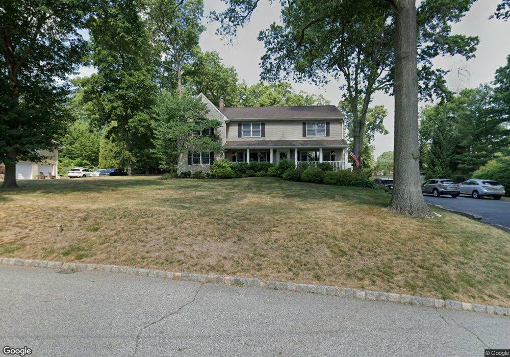
32 Woodcrest Rd Whippany, NJ 07981
Estimated Value: $975,776 - $1,117,000
--
Bed
--
Bath
3,724
Sq Ft
$277/Sq Ft
Est. Value
About This Home
This home is located at 32 Woodcrest Rd, Whippany, NJ 07981 and is currently estimated at $1,031,694, approximately $277 per square foot. 32 Woodcrest Rd is a home located in Morris County with nearby schools including Whippany Park High School, Arrow Academy, and The Morristown-Beard School.
Ownership History
Date
Name
Owned For
Owner Type
Purchase Details
Closed on
Jul 27, 2012
Sold by
Cantrell Sandra J
Bought by
Cantrell Sandra J and Cantrell Robert W
Current Estimated Value
Home Financials for this Owner
Home Financials are based on the most recent Mortgage that was taken out on this home.
Original Mortgage
$220,000
Interest Rate
3.7%
Mortgage Type
New Conventional
Create a Home Valuation Report for This Property
The Home Valuation Report is an in-depth analysis detailing your home's value as well as a comparison with similar homes in the area
Home Values in the Area
Average Home Value in this Area
Purchase History
| Date | Buyer | Sale Price | Title Company |
|---|---|---|---|
| Cantrell Sandra J | -- | Phoenix Assoc Title Agency I |
Source: Public Records
Mortgage History
| Date | Status | Borrower | Loan Amount |
|---|---|---|---|
| Closed | Cantrell Sandra J | $220,000 |
Source: Public Records
Tax History Compared to Growth
Tax History
| Year | Tax Paid | Tax Assessment Tax Assessment Total Assessment is a certain percentage of the fair market value that is determined by local assessors to be the total taxable value of land and additions on the property. | Land | Improvement |
|---|---|---|---|---|
| 2025 | $12,939 | $613,800 | $233,400 | $380,400 |
| 2024 | $12,884 | $613,800 | $233,400 | $380,400 |
| 2023 | $12,884 | $613,800 | $233,400 | $380,400 |
| 2022 | $11,785 | $613,800 | $233,400 | $380,400 |
| 2021 | $11,613 | $613,800 | $233,400 | $380,400 |
| 2020 | $11,576 | $613,800 | $233,400 | $380,400 |
| 2019 | $11,613 | $613,800 | $233,400 | $380,400 |
| 2018 | $11,411 | $613,800 | $233,400 | $380,400 |
| 2017 | $11,073 | $613,800 | $233,400 | $380,400 |
| 2016 | $10,913 | $613,800 | $233,400 | $380,400 |
| 2015 | $10,478 | $613,800 | $233,400 | $380,400 |
| 2014 | $10,250 | $613,800 | $233,400 | $380,400 |
Source: Public Records
Map
Nearby Homes
- 26 David Dr
- 11 Nemic Ln
- 45 Polhemus Terrace
- 74 Preston Rd
- 00 Algonquin Pkwy
- 39 Lefke Ln
- 96 Parsippany Rd
- 72 Schindler Ct
- 89 Schindler Ct
- 53 Westminster Dr
- 92 Sunrise Dr
- 2003 Vermont Terrace Unit 2003
- 26 Gladstone Ct
- 42 Gladstone Ct
- 34 Gladstone Ct
- 14 Gladstone Ct
- Monterey Plan at The Grove - The Monterey Collection
- Pershing Plan at The Grove - The Pershing Collection
- 709 Brook Hollow Dr Unit 709
- 91 Rhyan Dr
- 34 Woodcrest Rd
- 30 Woodcrest Rd
- 27 Woodcrest Rd
- 8 Glenn Place
- 38 Woodcrest Rd
- 35 Woodcrest Rd
- 28 Woodcrest Rd
- 10 Glenn Place
- 21 Woodcrest Rd
- 39 Woodcrest Rd
- 9 Glenn Place
- 40 Woodcrest Rd
- 8 Beaumont Place
- 6 Glenn Place
- 22 Woodcrest Rd
- 240 Bee Meadow Pkwy
- 238 Bee Meadow Pkwy
- 242 Bee Meadow Pkwy
- 19 Woodcrest Rd
- 9 Beaumont Place