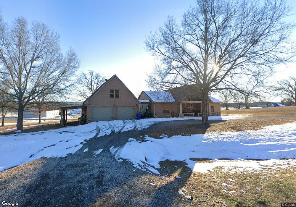
320 Highway 287 Greenbrier, AR 72058
Estimated Value: $445,000 - $499,000
--
Bed
4
Baths
2,481
Sq Ft
$190/Sq Ft
Est. Value
About This Home
This home is located at 320 Highway 287, Greenbrier, AR 72058 and is currently estimated at $471,270, approximately $189 per square foot. 320 Highway 287 is a home located in Faulkner County with nearby schools including Greenbrier Eastside Elementary School, Greenbrier Junior High School, and Greenbrier High School.
Ownership History
Date
Name
Owned For
Owner Type
Purchase Details
Closed on
Apr 20, 2022
Sold by
West Todd and West Paige
Bought by
Ward Christopher T and Ward Stephanie L
Current Estimated Value
Home Financials for this Owner
Home Financials are based on the most recent Mortgage that was taken out on this home.
Original Mortgage
$294,500
Outstanding Balance
$258,780
Interest Rate
3.85%
Mortgage Type
New Conventional
Estimated Equity
$212,490
Purchase Details
Closed on
Apr 9, 2018
Sold by
Housley Randall L and Housley Nicole M
Bought by
West Todd and West Paige
Home Financials for this Owner
Home Financials are based on the most recent Mortgage that was taken out on this home.
Original Mortgage
$318,250
Interest Rate
4.43%
Mortgage Type
New Conventional
Purchase Details
Closed on
Jul 17, 2013
Sold by
Arkavalley Air Park Llc
Bought by
Housley Randall L and Housley Nicole M
Create a Home Valuation Report for This Property
The Home Valuation Report is an in-depth analysis detailing your home's value as well as a comparison with similar homes in the area
Home Values in the Area
Average Home Value in this Area
Purchase History
| Date | Buyer | Sale Price | Title Company |
|---|---|---|---|
| Ward Christopher T | $419,500 | None Listed On Document | |
| West Todd | $335,000 | Faulkner County Title | |
| Housley Randall L | -- | None Available |
Source: Public Records
Mortgage History
| Date | Status | Borrower | Loan Amount |
|---|---|---|---|
| Open | Ward Christopher T | $294,500 | |
| Previous Owner | West Todd | $318,250 |
Source: Public Records
Tax History Compared to Growth
Tax History
| Year | Tax Paid | Tax Assessment Tax Assessment Total Assessment is a certain percentage of the fair market value that is determined by local assessors to be the total taxable value of land and additions on the property. | Land | Improvement |
|---|---|---|---|---|
| 2025 | $3,539 | $84,450 | $5,710 | $78,740 |
| 2024 | $3,406 | $84,450 | $5,710 | $78,740 |
| 2023 | $3,244 | $65,930 | $5,710 | $60,220 |
| 2022 | $2,486 | $65,930 | $5,710 | $60,220 |
| 2021 | $2,356 | $65,930 | $5,710 | $60,220 |
| 2020 | $2,226 | $52,870 | $4,940 | $47,930 |
| 2019 | $2,226 | $52,870 | $4,940 | $47,930 |
| 2018 | $2,251 | $52,870 | $4,940 | $47,930 |
| 2017 | $2,251 | $52,870 | $4,940 | $47,930 |
| 2016 | $2,244 | $52,720 | $4,940 | $47,780 |
| 2015 | $229 | $4,940 | $4,940 | $0 |
| 2014 | $229 | $2,470 | $2,470 | $0 |
Source: Public Records
Map
Nearby Homes
- 306 Highway 287
- Lot 4 Highway 287
- Lot 2 Highway 287
- Lot 1 Highway 287
- Lot 5 Highway 287
- 329 A Highway 287
- Lot 6 Highway 287
- 61 Wilderness Rd
- 141 Wilderness Rd
- 9 Country Cove
- Tract 1 Waterside Dr
- 11 Bell Cir
- 7 Bell Cir
- 10 Fox Hill Rd
- 16 Fox Hill Rd
- 11 Taryn Trail
- 23 Taryn Trail
- 12 Highland Dr
- 20 Autumn Hills Rd
- 30 Cold Spring Trail
- 320 Hwy 287
- 320 State Highway 287
- 3 Downwind Ave
- 321 Highway 287
- 321 State Highway 287
- 315-01 State Highway 287
- 319 State Highway 287
- 319 Highway 287
- 317 Highway 287
- 21 Piper Cove
- 0 Piper Cove Unit 16022104
- 4 Piper Cove
- 323 Highway 287
- 311 Highway 287
- 7 Piper Cove
- 4 Cessna Ave
- 325 Highway 287
- 0 Cessna Unit 20033058
- 9 Downwind Ave
- 2 Downwind Ave