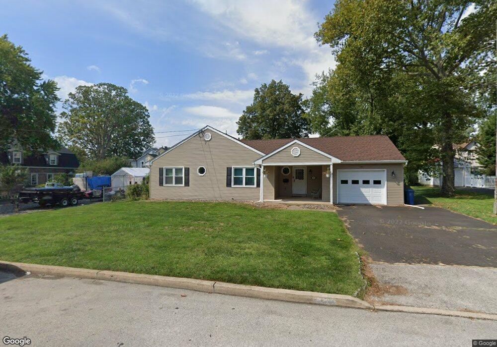
320 Maple Ave Glenside, PA 19038
Estimated Value: $452,000 - $498,000
3
Beds
2
Baths
1,802
Sq Ft
$263/Sq Ft
Est. Value
About This Home
This home is located at 320 Maple Ave, Glenside, PA 19038 and is currently estimated at $473,560, approximately $262 per square foot. 320 Maple Ave is a home located in Montgomery County with nearby schools including Copper Beech Elementary School, Abington Middle School, and Abington Senior High School.
Ownership History
Date
Name
Owned For
Owner Type
Purchase Details
Closed on
Nov 6, 2015
Sold by
Newman Patricia and Newman Patricia E
Bought by
Heckman Stephanie L
Current Estimated Value
Home Financials for this Owner
Home Financials are based on the most recent Mortgage that was taken out on this home.
Original Mortgage
$112,500
Outstanding Balance
$88,487
Interest Rate
3.79%
Mortgage Type
New Conventional
Estimated Equity
$385,073
Create a Home Valuation Report for This Property
The Home Valuation Report is an in-depth analysis detailing your home's value as well as a comparison with similar homes in the area
Home Values in the Area
Average Home Value in this Area
Purchase History
| Date | Buyer | Sale Price | Title Company |
|---|---|---|---|
| Heckman Stephanie L | $225,000 | Attorney |
Source: Public Records
Mortgage History
| Date | Status | Borrower | Loan Amount |
|---|---|---|---|
| Open | Heckman Stephanie L | $112,500 |
Source: Public Records
Tax History
| Year | Tax Paid | Tax Assessment Tax Assessment Total Assessment is a certain percentage of the fair market value that is determined by local assessors to be the total taxable value of land and additions on the property. | Land | Improvement |
|---|---|---|---|---|
| 2025 | $7,172 | $154,880 | $53,260 | $101,620 |
| 2024 | $7,172 | $154,880 | $53,260 | $101,620 |
| 2023 | $6,873 | $154,880 | $53,260 | $101,620 |
| 2022 | $6,653 | $154,880 | $53,260 | $101,620 |
| 2021 | $6,295 | $154,880 | $53,260 | $101,620 |
| 2020 | $6,205 | $154,880 | $53,260 | $101,620 |
| 2019 | $6,205 | $154,880 | $53,260 | $101,620 |
Source: Public Records
Map
Nearby Homes
- 2718 Hawthorne Rd
- 461 Hamel Ave
- 3009 Limekiln Pike
- 2621 Hawthorne Rd
- 152 Egerton Ave
- 624 Hamel Ave
- 630 Monroe Ave
- 616 Tennis Ave
- 245 Linden Ave
- 630 Jackson Ave
- 57 Chelfield Rd
- 776 Brooke Rd
- 329 N Tyson Ave
- 250 Logan Ave
- 445 Tyson Ave
- 257 Girard Ave
- 717 Garfield Ave
- 65 Limekiln Pike
- 3113 Jenkintown Rd
- 523 W Glenside Ave
Your Personal Tour Guide
Ask me questions while you tour the home.