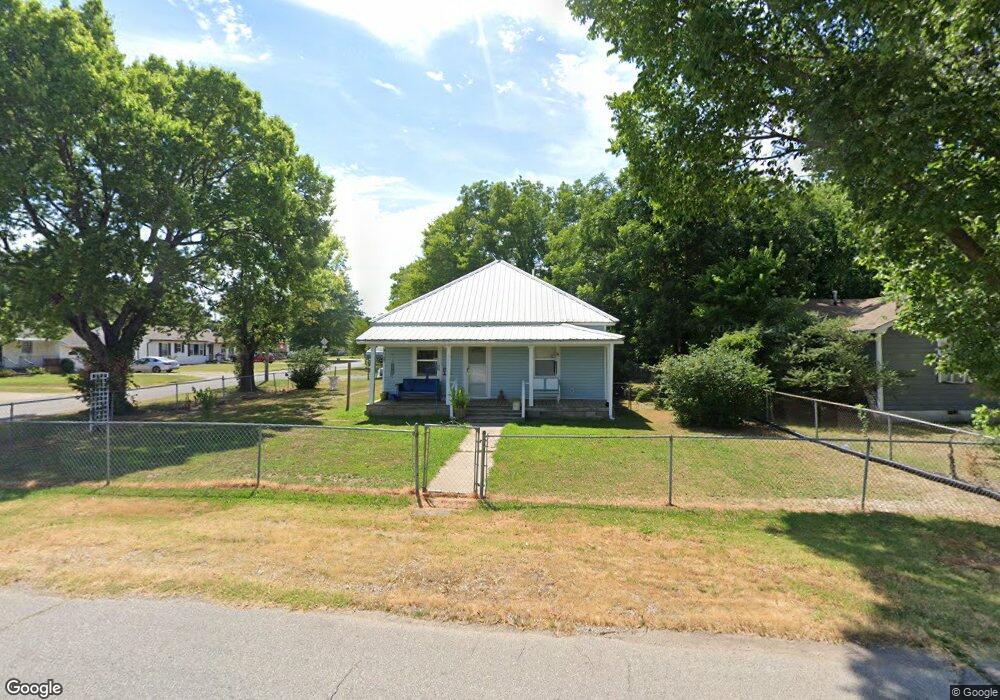
320 S Locust St Skiatook, OK 74070
Estimated Value: $136,016 - $169,000
3
Beds
1
Bath
1,100
Sq Ft
$136/Sq Ft
Est. Value
About This Home
This home is located at 320 S Locust St, Skiatook, OK 74070 and is currently estimated at $149,504, approximately $135 per square foot. 320 S Locust St is a home located in Osage County with nearby schools including Marrs Elementary School, Newman Middle School, and Skiatook High School.
Ownership History
Date
Name
Owned For
Owner Type
Purchase Details
Closed on
Aug 3, 2018
Sold by
Downing Craig D and Downing Lenda
Bought by
Brumlbey Vicki
Current Estimated Value
Purchase Details
Closed on
Jun 15, 2004
Sold by
Pippin John W and Pippin Dorothy J
Bought by
Pippin John W & Rev Living Trust
Purchase Details
Closed on
Dec 1, 1995
Sold by
Hull Jacqueline Joyce Steven
Bought by
Pippin John W and Pippin Dorothy J
Purchase Details
Closed on
Jun 24, 1994
Sold by
Moyer Nadine
Bought by
Moyer Rolland
Create a Home Valuation Report for This Property
The Home Valuation Report is an in-depth analysis detailing your home's value as well as a comparison with similar homes in the area
Home Values in the Area
Average Home Value in this Area
Purchase History
| Date | Buyer | Sale Price | Title Company |
|---|---|---|---|
| Brumlbey Vicki | $87,000 | -- | |
| Pippin John W & Rev Living Trust | -- | -- | |
| Pippin John W | $31,400 | -- | |
| Moyer Rolland | -- | -- |
Source: Public Records
Tax History Compared to Growth
Tax History
| Year | Tax Paid | Tax Assessment Tax Assessment Total Assessment is a certain percentage of the fair market value that is determined by local assessors to be the total taxable value of land and additions on the property. | Land | Improvement |
|---|---|---|---|---|
| 2025 | $700 | $8,034 | $1,661 | $6,373 |
| 2024 | $679 | $7,800 | $1,613 | $6,187 |
| 2023 | $679 | $7,800 | $1,613 | $6,187 |
| 2022 | $674 | $7,800 | $1,613 | $6,187 |
| 2021 | $676 | $7,800 | $1,613 | $6,187 |
| 2020 | $920 | $10,205 | $1,613 | $8,592 |
| 2019 | $1,033 | $10,205 | $1,613 | $8,592 |
| 2018 | $363 | $3,600 | $1,613 | $1,987 |
| 2017 | $0 | $5,104 | $1,613 | $3,491 |
| 2016 | -- | $4,956 | $1,613 | $3,343 |
| 2015 | -- | $4,811 | $1,613 | $3,198 |
| 2014 | -- | $4,671 | $1,613 | $3,058 |
| 2013 | $439 | $4,535 | $1,613 | $2,922 |
Source: Public Records
Map
Nearby Homes
- 209 W 3rd St
- 001 4th St
- 002 4th St
- 715 W 4th St
- 1001 County Road 2265
- 534 S Osage St
- 615 S Haynie St
- 106 S A St Unit 11
- 106 S A St Unit 3
- 724 S Haynie St
- 101 E 1st St
- 0 E Maple St
- 305 E Elm St
- 0 Bulldog St
- 0 W 4th St Unit 2510752
- 312 E Elm St
- 14 W Chestnut St
- 1122 S Russell St
- 133 W Chestnut Place
- 1127 S Russell St