Estimated Value: $202,000 - $322,000
--
Bed
--
Bath
--
Sq Ft
0.34
Acres
About This Home
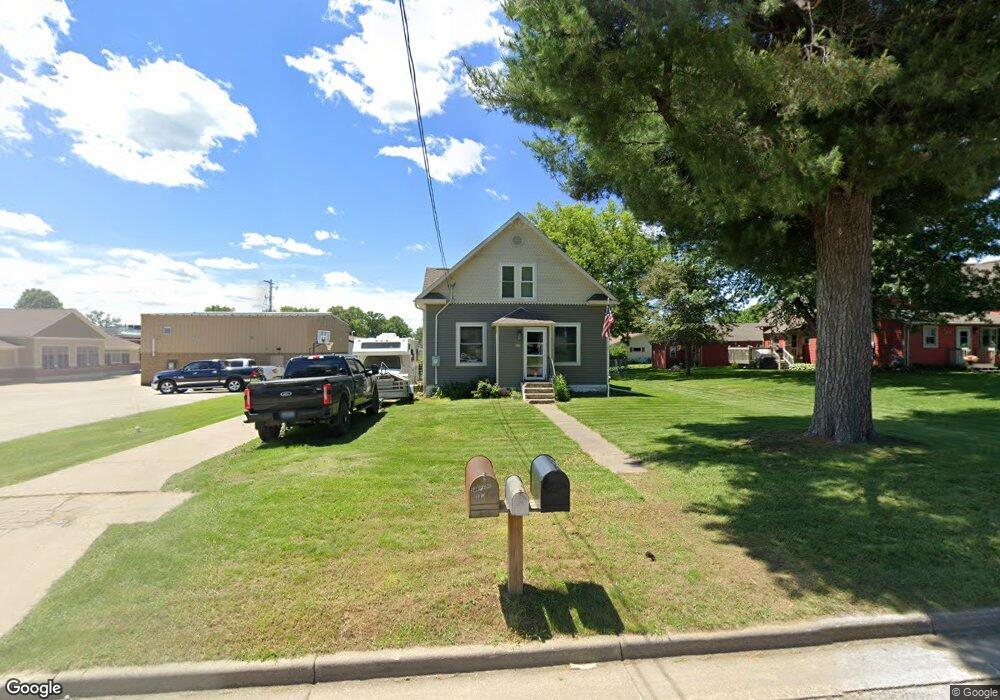
This home is located at 320 S Peterson Ave, Blair, WI 54616 and is currently estimated at $242,837. 320 S Peterson Ave is a home located in Trempealeau County with nearby schools including Blair-Taylor Elementary School, Blair-Taylor Middle/High School, and Pinehill Amish School.
Ownership History
Date
Name
Owned For
Owner Type
Purchase Details
Closed on
Sep 14, 2011
Sold by
Howe Lannie L and Stumlin-Howe Danelle D
Bought by
Howe Lannie L and Stumlin-Howe Danelle D
Current Estimated Value
Home Financials for this Owner
Home Financials are based on the most recent Mortgage that was taken out on this home.
Original Mortgage
$102,000
Interest Rate
4.14%
Mortgage Type
Purchase Money Mortgage
Create a Home Valuation Report for This Property
The Home Valuation Report is an in-depth analysis detailing your home's value as well as a comparison with similar homes in the area
Home Values in the Area
Average Home Value in this Area
Purchase History
| Date | Buyer | Sale Price | Title Company |
|---|---|---|---|
| Howe Lannie L | -- | -- |
Source: Public Records
Mortgage History
| Date | Status | Borrower | Loan Amount |
|---|---|---|---|
| Closed | Howe Lannie L | $102,000 |
Source: Public Records
Tax History Compared to Growth
Tax History
| Year | Tax Paid | Tax Assessment Tax Assessment Total Assessment is a certain percentage of the fair market value that is determined by local assessors to be the total taxable value of land and additions on the property. | Land | Improvement |
|---|---|---|---|---|
| 2024 | $3,342 | $208,600 | $10,300 | $198,300 |
| 2023 | $3,288 | $124,000 | $13,500 | $110,500 |
| 2022 | $3,129 | $124,000 | $13,500 | $110,500 |
| 2021 | $2,676 | $124,000 | $13,500 | $110,500 |
| 2020 | $2,626 | $24,550 | $13,500 | $11,050 |
| 2019 | $2,754 | $124,000 | $13,500 | $110,500 |
| 2018 | $2,397 | $124,000 | $13,500 | $110,500 |
| 2017 | $2,506 | $124,000 | $13,500 | $110,500 |
| 2016 | $2,303 | $124,000 | $13,500 | $110,500 |
| 2015 | $2,749 | $124,000 | $13,500 | $110,500 |
| 2014 | $2,549 | $124,000 | $13,500 | $110,500 |
| 2011 | $1,509 | $69,800 | $8,000 | $61,800 |
Source: Public Records
Map
Nearby Homes
- 102 S Peterson Ave
- 328 S Urberg Ave
- 517 W Broadway St
- 127 E Broadway St
- 313 S Park Rd
- 612 E Broadway St
- N34701 County Rd S
- N28881 County Rd S
- N34701 County Rd N
- N34855 County Rd S
- N32838 Briten Rd
- XX Vold Rd
- N27146 County Rd S
- N27046 County Rd S
- W19292 Wisconsin 95
- 00 Joe Coulee Rd
- N30732 Square Bluff Rd
- 0 Helstad Coulee Rd
- N26144 Joe Coulee Rd
- 18124 Fredrickson St
- 312 S Peterson Ave
- 335 S Peterson Ave
- 404 S Peterson Ave
- 521 Sylfest St
- 319 S Peterson Ave
- 403 S Peterson Ave
- 327 S Peterson Ave
- 408 S Peterson Ave
- 224 S Peterson Ave
- 320 S Spring St
- 219 S Peterson Ave
- 401 S Spring St
- 412 W 2nd St
- 425 S Peterson Ave
- 606 Sylfest St
- 220 S Spring St
- 0 W 4th St Unit LOT 1
- 415 S Spring St
- 417 W 1st St
- 320 W 2nd St