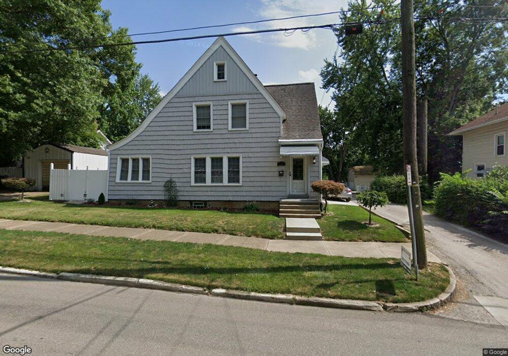
320 W Bowman St Wooster, OH 44691
Estimated Value: $179,000 - $201,585
3
Beds
1
Bath
2,032
Sq Ft
$93/Sq Ft
Est. Value
About This Home
This home is located at 320 W Bowman St, Wooster, OH 44691 and is currently estimated at $188,896, approximately $92 per square foot. 320 W Bowman St is a home located in Wayne County with nearby schools including Cornerstone Elementary School, Edgewood Middle School, and Wooster High School.
Ownership History
Date
Name
Owned For
Owner Type
Purchase Details
Closed on
May 29, 1992
Sold by
Newsome Duane O and Newsome Carol A
Bought by
Bishop Melody Lee
Current Estimated Value
Purchase Details
Closed on
May 17, 1988
Sold by
Denning Robert M and Denning Carol
Bought by
Newsome Duane O and Newsome Carol A
Purchase Details
Closed on
Oct 16, 1987
Sold by
Denning Robert M and Denning Carol
Bought by
Denning Robert M and Denning Carol
Create a Home Valuation Report for This Property
The Home Valuation Report is an in-depth analysis detailing your home's value as well as a comparison with similar homes in the area
Home Values in the Area
Average Home Value in this Area
Purchase History
| Date | Buyer | Sale Price | Title Company |
|---|---|---|---|
| Bishop Melody Lee | $53,500 | -- | |
| Newsome Duane O | $49,600 | -- | |
| Denning Robert M | $34,000 | -- |
Source: Public Records
Tax History Compared to Growth
Tax History
| Year | Tax Paid | Tax Assessment Tax Assessment Total Assessment is a certain percentage of the fair market value that is determined by local assessors to be the total taxable value of land and additions on the property. | Land | Improvement |
|---|---|---|---|---|
| 2024 | $2,324 | $56,020 | $6,610 | $49,410 |
| 2023 | $2,324 | $56,020 | $6,610 | $49,410 |
| 2022 | $2,213 | $42,440 | $5,010 | $37,430 |
| 2021 | $2,282 | $42,440 | $5,010 | $37,430 |
| 2020 | $2,164 | $42,440 | $5,010 | $37,430 |
| 2019 | $1,676 | $31,540 | $5,070 | $26,470 |
| 2018 | $1,680 | $31,540 | $5,070 | $26,470 |
| 2017 | $1,671 | $31,540 | $5,070 | $26,470 |
| 2016 | $1,746 | $30,340 | $4,880 | $25,460 |
| 2015 | $1,714 | $30,340 | $4,880 | $25,460 |
| 2014 | $1,715 | $30,340 | $4,880 | $25,460 |
| 2013 | $1,818 | $31,790 | $4,900 | $26,890 |
Source: Public Records
Map
Nearby Homes
- 537 N Grant St
- 450 N Grant St
- 406 N Walnut St
- 143 Park Ave
- 412 Emerick St
- 534 N Buckeye St
- 423 N Market St
- 323 N Grant St
- 429 Woodland Ave
- 227 N Walnut St
- 229 N Walnut St
- 349 W North St
- 657 N Bever St
- 329 E Bowman St
- 900 Quinby Ave
- 336 Spring St
- 1117 Quinby Ave
- 1123 Quinby Ave
- 554 Nold Ave
- 548 Spring St
- 328 W Bowman St
- 578 N Grant St
- 584 N Grant St
- 589 Emerick St
- 581 Emerick St
- 604 N Grant St
- 321 W Bowman St
- 572 N Grant St
- 573 Emerick St
- 606 N Grant St
- 543545 N Grant St
- 323 W Bowman St
- 564 N Grant St
- 564 N Grant St
- 577 Emerick St
- 335 W Bowman St
- 614 N Grant St
- 218 W Bowman St
- 343 W Bowman St
- 343 W Bowman St