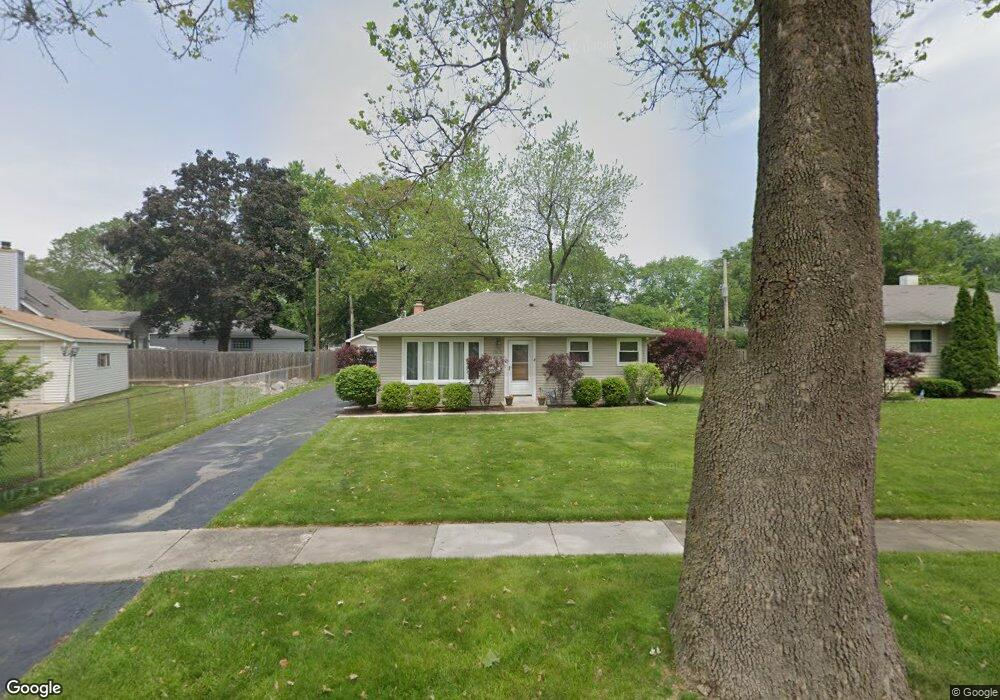
3202 Thrush Ln Rolling Meadows, IL 60008
Estimated Value: $317,000 - $359,000
3
Beds
1
Bath
1,290
Sq Ft
$268/Sq Ft
Est. Value
About This Home
This home is located at 3202 Thrush Ln, Rolling Meadows, IL 60008 and is currently estimated at $345,183, approximately $267 per square foot. 3202 Thrush Ln is a home located in Cook County with nearby schools including Kimball Hill Elementary School, Carl Sandburg Junior High School, and Rolling Meadows High School.
Ownership History
Date
Name
Owned For
Owner Type
Purchase Details
Closed on
Mar 15, 2000
Sold by
Darr Kenneth E and Darr Sue E
Bought by
Zimmerman Paxton
Current Estimated Value
Home Financials for this Owner
Home Financials are based on the most recent Mortgage that was taken out on this home.
Original Mortgage
$142,500
Outstanding Balance
$46,090
Interest Rate
8.3%
Estimated Equity
$299,093
Create a Home Valuation Report for This Property
The Home Valuation Report is an in-depth analysis detailing your home's value as well as a comparison with similar homes in the area
Home Values in the Area
Average Home Value in this Area
Purchase History
| Date | Buyer | Sale Price | Title Company |
|---|---|---|---|
| Zimmerman Paxton | $150,000 | -- |
Source: Public Records
Mortgage History
| Date | Status | Borrower | Loan Amount |
|---|---|---|---|
| Open | Zimmerman Paxton | $142,500 |
Source: Public Records
Tax History Compared to Growth
Tax History
| Year | Tax Paid | Tax Assessment Tax Assessment Total Assessment is a certain percentage of the fair market value that is determined by local assessors to be the total taxable value of land and additions on the property. | Land | Improvement |
|---|---|---|---|---|
| 2025 | $6,339 | $30,000 | $5,407 | $24,593 |
| 2024 | $6,339 | $24,000 | $4,575 | $19,425 |
| 2023 | $6,040 | $24,000 | $4,575 | $19,425 |
| 2022 | $6,040 | $24,000 | $4,575 | $19,425 |
| 2021 | $4,500 | $16,920 | $2,703 | $14,217 |
| 2020 | $4,468 | $16,920 | $2,703 | $14,217 |
| 2019 | $4,502 | $18,905 | $2,703 | $16,202 |
| 2018 | $4,571 | $17,549 | $2,495 | $15,054 |
| 2017 | $5,769 | $21,556 | $2,495 | $19,061 |
| 2016 | $5,634 | $21,556 | $2,495 | $19,061 |
| 2015 | $4,699 | $17,547 | $2,287 | $15,260 |
| 2014 | $4,850 | $18,349 | $2,287 | $16,062 |
| 2013 | $4,715 | $18,349 | $2,287 | $16,062 |
Source: Public Records
Map
Nearby Homes
- 3200 Thrush Ln
- 3407 Pheasant Dr
- 3100 Town Square Dr Unit 308
- 2709 Lily Ln
- 4101 Owl Dr
- 2705 Park St
- 2503 Fulle St Unit 17
- 2107 Kirchoff Rd
- 2212 Fulle St
- 2404 Sigwalt St
- 2930 Northampton Dr Unit A2
- 2600 Brookwood Way Dr Unit 316
- 2600 Brookwood Way Dr Unit 305
- 2600 Brookwood Unit 314
- 2401 Rohlwing Rd
- 2650 Brookwood Way Dr Unit 108
- 2508 Algonquin Rd Unit 16
- 3000 California Ave
- 1117 S Old Wilke Rd Unit 206
- 2408 Algonquin Rd Unit 3
- 3204 Thrush Ln
- 3406 Pheasant Dr
- 3108 Thrush Ln
- 3109 Swallow Ln
- 3201 Swallow Ln
- 3107 Swallow Ln
- 3404 Pheasant Dr
- 3203 Swallow Ln
- 3106 Thrush Ln
- 3205 Thrush Ct
- 3105 Swallow Ln
- 3203 Thrush Ln
- 3205 Swallow Ln
- 3104 Thrush Ln
- 3201 Thrush Ct
- 3103 Swallow Ln
- 3506 Pheasant Dr
- 3411 Pheasant Dr
- 3101 Swallow Ln
- 3409 Pheasant Dr