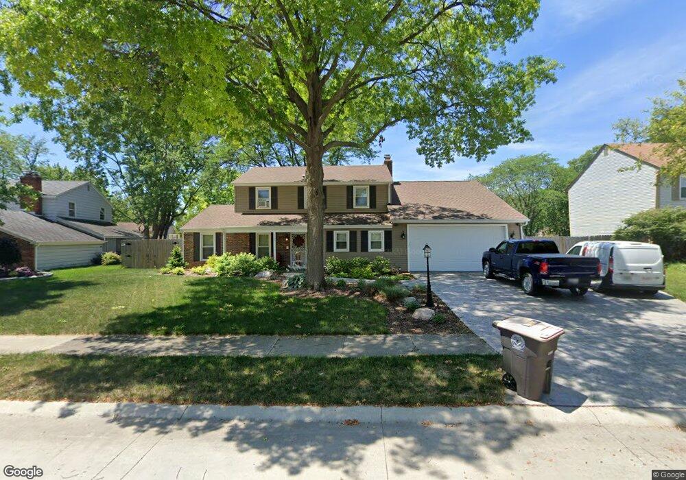
3203 SiMcOe Ct Fort Wayne, IN 46815
Blackhawk NeighborhoodEstimated Value: $263,492 - $297,000
4
Beds
3
Baths
1,992
Sq Ft
$138/Sq Ft
Est. Value
About This Home
This home is located at 3203 SiMcOe Ct, Fort Wayne, IN 46815 and is currently estimated at $275,873, approximately $138 per square foot. 3203 SiMcOe Ct is a home located in Allen County with nearby schools including Glenwood Park Elementary School, Blackhawk Middle School, and R Nelson Snider High School.
Ownership History
Date
Name
Owned For
Owner Type
Purchase Details
Closed on
Mar 25, 2010
Sold by
Emmons Janice L
Bought by
Emmons Harold L and Emmons Janice L
Current Estimated Value
Home Financials for this Owner
Home Financials are based on the most recent Mortgage that was taken out on this home.
Original Mortgage
$53,100
Interest Rate
5.1%
Mortgage Type
New Conventional
Purchase Details
Closed on
Jan 24, 2001
Sold by
Olson Edwin C and Olson Kay M
Bought by
Emmons Janice L
Home Financials for this Owner
Home Financials are based on the most recent Mortgage that was taken out on this home.
Original Mortgage
$108,202
Outstanding Balance
$37,482
Interest Rate
7.22%
Mortgage Type
FHA
Estimated Equity
$238,391
Create a Home Valuation Report for This Property
The Home Valuation Report is an in-depth analysis detailing your home's value as well as a comparison with similar homes in the area
Home Values in the Area
Average Home Value in this Area
Purchase History
| Date | Buyer | Sale Price | Title Company |
|---|---|---|---|
| Emmons Harold L | -- | Landquest Title | |
| Emmons Janice L | -- | Three Rivers Title Company I |
Source: Public Records
Mortgage History
| Date | Status | Borrower | Loan Amount |
|---|---|---|---|
| Closed | Emmons Harold L | $53,100 | |
| Open | Emmons Janice L | $108,202 |
Source: Public Records
Tax History
| Year | Tax Paid | Tax Assessment Tax Assessment Total Assessment is a certain percentage of the fair market value that is determined by local assessors to be the total taxable value of land and additions on the property. | Land | Improvement |
|---|---|---|---|---|
| 2025 | $2,677 | $250,000 | $29,500 | $220,500 |
| 2024 | $2,677 | $234,400 | $29,500 | $204,900 |
| 2023 | $2,623 | $222,600 | $29,500 | $193,100 |
| 2022 | $2,266 | $198,700 | $29,500 | $169,200 |
| 2021 | $1,911 | $168,200 | $22,700 | $145,500 |
| 2020 | $1,784 | $159,300 | $22,700 | $136,600 |
| 2019 | $1,776 | $158,800 | $22,700 | $136,100 |
| 2018 | $1,745 | $146,200 | $22,700 | $123,500 |
| 2017 | $1,649 | $136,900 | $22,700 | $114,200 |
| 2016 | $1,633 | $144,200 | $22,700 | $121,500 |
| 2014 | $1,559 | $130,800 | $22,700 | $108,100 |
| 2013 | $1,573 | $132,000 | $22,700 | $109,300 |
Source: Public Records
Map
Nearby Homes
- 3210 Arrowwood Dr
- 7107 Piegan Place
- 3604 Burrwood Terrace
- 6124 Millhollow Ln
- 6113 Millhollow Ln
- 3502 Weston Ridge Place
- 6601 Bennington Dr
- 5717 Bayside Dr
- 5720 Bayside Dr
- 5826 Thoreau Ave
- 5723 Port Royal
- 5722 Port Royal
- 2611 Neptunes Crossing
- 3303 Walden Run
- 7530 Glenoak Pkwy
- 6038 Monarch Dr
- 6508 Birchdale Dr
- 7728 Wishingwell Ct
- 1605 Benham Dr
- 3414 Country Park Ln
- 3121 SiMcOe Ct
- 3209 SiMcOe Ct
- 3210 Kenaston Dr
- 3204 Kenaston Dr
- 3218 Kenaston Dr
- 3111 SiMcOe Ct
- 3204 SiMcOe Ct
- 3126 Kenaston Dr
- 3208 SiMcOe Ct
- 3230 Kenaston Dr
- 3120 SiMcOe Ct
- 3216 SiMcOe Ct
- 3116 Kenaston Dr
- 3225 SiMcOe Ct
- 3101 SiMcOe Ct
- 3220 SiMcOe Ct
- 6517 Pawawna Dr
- 6601 Pawawna Dr
- 3221 Kenaston Dr
- 6421 Wayoata Ct
Your Personal Tour Guide
Ask me questions while you tour the home.