J
Seller's Agent in 2025
Joseph Costello
Costello Realty & Mgmt
(702) 882-3814
1 in this area
4 Total Sales

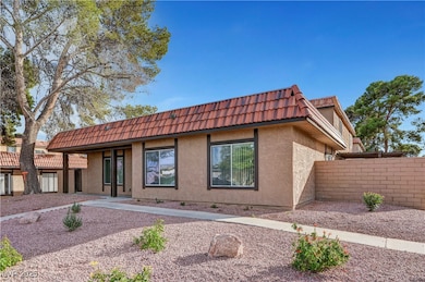
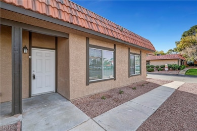
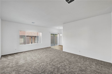
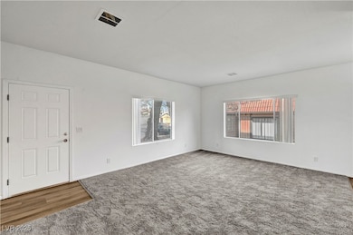
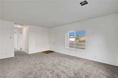
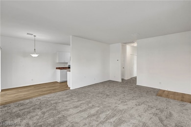
Completely rebuilt from the ground up, this beautiful condo sits proudly on its original slab after a previous fire. Everything above the foundation is brand new—framing, electrical, plumbing, roof, HVAC, kitchen, bathrooms, and finishes—offering the peace of mind of new construction in an established community. Features a bright, open layout, modern kitchen with new appliances and countertops, and stylishly updated bathrooms. Includes a rare two-car detached garage for added convenience and storage. Enjoy resort-style amenities including a pool, clubhouse, and tennis courts. A rare FIRE SALE opportunity—this one will not last!
Last Agent to Sell the Property
Costello Realty & Mgmt Brokerage Phone: 702-724-0040 License #S.0172331 Listed on: 11/10/2025
| Date | Type | Sale Price | Title Company |
|---|---|---|---|
| Bargain Sale Deed | $237,300 | Equity Title | |
| Bargain Sale Deed | $170,000 | Lawyers Title Of Nevada | |
| Interfamily Deed Transfer | -- | North American Title Company | |
| Interfamily Deed Transfer | -- | -- | |
| Bargain Sale Deed | $100,000 | National Title Company | |
| Quit Claim Deed | -- | Old Republic Title |
| Date | Status | Loan Amount | Loan Type |
|---|---|---|---|
| Open | $230,181 | New Conventional | |
| Previous Owner | $75,000 | Unknown |
| Date | Event | Price | List to Sale | Price per Sq Ft |
|---|---|---|---|---|
| 12/31/2025 12/31/25 | Sold | $237,300 | -4.5% | $202 / Sq Ft |
| 12/18/2025 12/18/25 | Pending | -- | -- | -- |
| 11/20/2025 11/20/25 | Price Changed | $248,500 | -3.3% | $211 / Sq Ft |
| 11/10/2025 11/10/25 | For Sale | $257,000 | -- | $219 / Sq Ft |
| Year | Tax Paid | Tax Assessment Tax Assessment Total Assessment is a certain percentage of the fair market value that is determined by local assessors to be the total taxable value of land and additions on the property. | Land | Improvement |
|---|---|---|---|---|
| 2026 | $865 | $34,078 | $17,500 | $16,578 |
| 2025 | $801 | $36,038 | $18,900 | $17,138 |
| 2024 | $743 | $36,038 | $18,900 | $17,138 |
| 2023 | $743 | $37,898 | $21,350 | $16,548 |
| 2022 | $688 | $32,146 | $16,450 | $15,696 |
| 2021 | $637 | $30,595 | $15,050 | $15,545 |
| 2020 | $589 | $29,383 | $13,650 | $15,733 |
| 2019 | $552 | $25,683 | $9,800 | $15,883 |
| 2018 | $526 | $22,219 | $6,650 | $15,569 |
| 2017 | $724 | $22,072 | $5,950 | $16,122 |
| 2016 | $494 | $20,401 | $4,200 | $16,201 |
| 2015 | $492 | $19,031 | $3,850 | $15,181 |
| 2014 | $477 | $15,574 | $2,100 | $13,474 |
J
Seller's Agent in 2025
Joseph Costello
Costello Realty & Mgmt
(702) 882-3814
1 in this area
4 Total Sales

Buyer's Agent in 2025
Denille Ingalls
Signature Real Estate Group
(702) 218-2095
1 in this area
5 Total Sales
Source: Las Vegas REALTORS®
MLS Number: 2734267
APN: 138-26-410-197
Disclaimer: Certain information contained herein is derived from information provided by parties other than Homes.com. All information provided is deemed reliable, but is not guaranteed to be accurate and should be independently verified.
![]() The data relating to real estate for sale on this web site comes in part from the INTERNET DATA EXCHANGE Program of the Greater Las Vegas Association of REALTORS® MLS. Real estate listings held by brokerage firms other than this site owner are marked with the IDX logo. Information is deemed reliable but not guaranteed. Copyright 2026 of the Greater Las Vegas Association of REALTORS® MLS. All rights reserved.
The data relating to real estate for sale on this web site comes in part from the INTERNET DATA EXCHANGE Program of the Greater Las Vegas Association of REALTORS® MLS. Real estate listings held by brokerage firms other than this site owner are marked with the IDX logo. Information is deemed reliable but not guaranteed. Copyright 2026 of the Greater Las Vegas Association of REALTORS® MLS. All rights reserved.
Ask me questions while you tour the home.