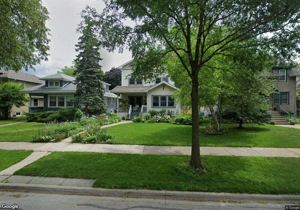
321 Franklin Ave River Forest, IL 60305
Estimated Value: $763,000 - $828,000
4
Beds
3
Baths
2,252
Sq Ft
$353/Sq Ft
Est. Value
About This Home
This home is located at 321 Franklin Ave, River Forest, IL 60305 and is currently estimated at $794,204, approximately $352 per square foot. 321 Franklin Ave is a home located in Cook County with nearby schools including Lincoln Elementary School, Roosevelt Middle School, and Oak Park and River Forest High School.
Ownership History
Date
Name
Owned For
Owner Type
Purchase Details
Closed on
Nov 21, 1997
Sold by
Dudek Stephan J and Morey Carole A
Bought by
Faland Bruce and Faland Maribeth
Current Estimated Value
Home Financials for this Owner
Home Financials are based on the most recent Mortgage that was taken out on this home.
Original Mortgage
$212,000
Outstanding Balance
$36,244
Interest Rate
7.75%
Estimated Equity
$757,960
Create a Home Valuation Report for This Property
The Home Valuation Report is an in-depth analysis detailing your home's value as well as a comparison with similar homes in the area
Home Values in the Area
Average Home Value in this Area
Purchase History
| Date | Buyer | Sale Price | Title Company |
|---|---|---|---|
| Faland Bruce | $265,000 | -- |
Source: Public Records
Mortgage History
| Date | Status | Borrower | Loan Amount |
|---|---|---|---|
| Open | Faland Bruce | $212,000 |
Source: Public Records
Tax History Compared to Growth
Tax History
| Year | Tax Paid | Tax Assessment Tax Assessment Total Assessment is a certain percentage of the fair market value that is determined by local assessors to be the total taxable value of land and additions on the property. | Land | Improvement |
|---|---|---|---|---|
| 2024 | $15,883 | $63,988 | $8,611 | $55,377 |
| 2023 | $14,287 | $68,440 | $8,611 | $59,829 |
| 2022 | $14,287 | $50,400 | $7,409 | $42,991 |
| 2021 | $14,638 | $50,400 | $7,409 | $42,991 |
| 2020 | $15,362 | $53,658 | $7,409 | $46,249 |
| 2019 | $12,955 | $45,160 | $6,808 | $38,352 |
| 2018 | $12,262 | $45,160 | $6,808 | $38,352 |
| 2017 | $14,442 | $52,692 | $6,808 | $45,884 |
| 2016 | $12,741 | $42,102 | $5,607 | $36,495 |
| 2015 | $12,476 | $42,102 | $5,607 | $36,495 |
| 2014 | $11,444 | $42,102 | $5,607 | $36,495 |
| 2013 | $13,930 | $51,998 | $5,607 | $46,391 |
Source: Public Records
Map
Nearby Homes
- 213 Ashland Ave
- 410 Ashland Ave Unit 1A
- 407 Ashland Ave Unit 3G
- 414 Franklin Ave Unit 3A
- 133 Ashland Ave
- 424 Park Ave Unit 206
- 534 Lathrop Ave
- 310 Lathrop Ave Unit P52
- 7415 Dixon St
- 314 Lathrop Ave Unit 502
- 314 Lathrop Ave Unit 604
- 314 Lathrop Ave Unit 507
- 7449 Washington St Unit 207
- 547 Jackson Ave
- 37 Forest Ave
- 7421 Washington St
- 435 William St Unit 205
- 435 William St Unit 607
- 414 Clinton Place Unit 302
- 7240 Franklin St Unit 2A
- 317 Franklin Ave
- 325 Franklin Ave
- 329 Franklin Ave
- 315 Franklin Ave
- 333 Franklin Ave
- 335 Franklin Ave
- 307 Franklin Ave
- 320 Ashland Ave
- 322 Ashland Ave
- 316 Ashland Ave
- 326 Ashland Ave
- 314 Ashland Ave
- 328 Ashland Ave
- 339 Franklin Ave
- 303 Franklin Ave
- 310 Ashland Ave
- 320 Franklin Ave
- 334 Ashland Ave
- 308 Ashland Ave
- 314 Franklin Ave