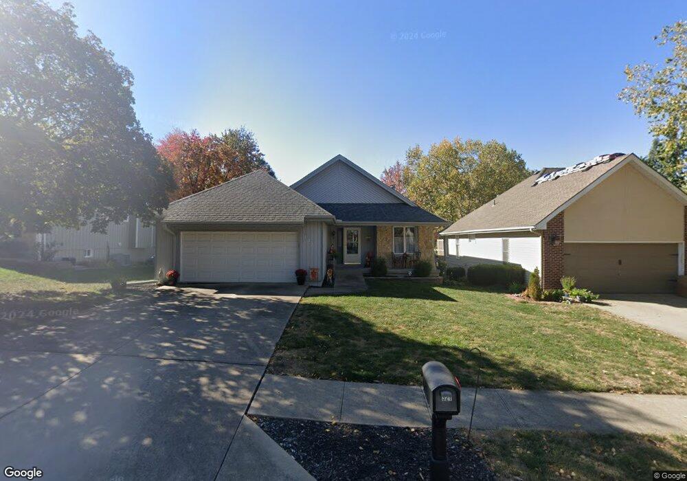
321 Lancelot Dr Liberty, MO 64068
Estimated Value: $282,000 - $340,000
2
Beds
2
Baths
1,405
Sq Ft
$215/Sq Ft
Est. Value
About This Home
This home is located at 321 Lancelot Dr, Liberty, MO 64068 and is currently estimated at $302,702, approximately $215 per square foot. 321 Lancelot Dr is a home located in Clay County with nearby schools including Lewis And Clark Elementary School, Heritage Middle School, and Liberty North High School.
Ownership History
Date
Name
Owned For
Owner Type
Purchase Details
Closed on
Nov 15, 2019
Sold by
Hampton Georgia M
Bought by
Kurtenbach Anne C
Current Estimated Value
Home Financials for this Owner
Home Financials are based on the most recent Mortgage that was taken out on this home.
Original Mortgage
$147,200
Outstanding Balance
$129,627
Interest Rate
3.65%
Mortgage Type
New Conventional
Estimated Equity
$173,075
Purchase Details
Closed on
Sep 8, 2000
Sold by
Hampton Georgia Mae
Bought by
Lovejoy Deborah Ann and Hampton Randall Stephen
Purchase Details
Closed on
Jun 16, 2000
Sold by
Edison Carolyn
Bought by
Hampton Georgia M
Home Financials for this Owner
Home Financials are based on the most recent Mortgage that was taken out on this home.
Original Mortgage
$61,000
Interest Rate
8.3%
Create a Home Valuation Report for This Property
The Home Valuation Report is an in-depth analysis detailing your home's value as well as a comparison with similar homes in the area
Home Values in the Area
Average Home Value in this Area
Purchase History
| Date | Buyer | Sale Price | Title Company |
|---|---|---|---|
| Kurtenbach Anne C | -- | Stewart Title Co | |
| Lovejoy Deborah Ann | -- | -- | |
| Hampton Georgia M | -- | Thomson Title Corp |
Source: Public Records
Mortgage History
| Date | Status | Borrower | Loan Amount |
|---|---|---|---|
| Open | Kurtenbach Anne C | $147,200 | |
| Previous Owner | Hampton Georgia M | $61,000 |
Source: Public Records
Tax History Compared to Growth
Tax History
| Year | Tax Paid | Tax Assessment Tax Assessment Total Assessment is a certain percentage of the fair market value that is determined by local assessors to be the total taxable value of land and additions on the property. | Land | Improvement |
|---|---|---|---|---|
| 2025 | $3,278 | $45,510 | -- | -- |
| 2024 | $3,278 | $42,620 | -- | -- |
| 2023 | $3,333 | $42,620 | $0 | $0 |
| 2022 | $2,851 | $35,990 | $0 | $0 |
| 2021 | $2,829 | $35,986 | $5,700 | $30,286 |
| 2020 | $2,715 | $32,430 | $0 | $0 |
| 2019 | $2,714 | $32,433 | $5,700 | $26,733 |
| 2018 | $2,508 | $29,430 | $0 | $0 |
| 2017 | $2,485 | $29,430 | $6,460 | $22,970 |
| 2016 | $2,485 | $29,430 | $6,460 | $22,970 |
| 2015 | $2,485 | $29,430 | $6,460 | $22,970 |
| 2014 | $2,505 | $29,430 | $6,460 | $22,970 |
Source: Public Records
Map
Nearby Homes
- 523 Lancelot Dr
- 527 Lancelot Dr
- 417 Locust St
- 194 Camelot Dr
- 815 Kings Ridge
- 1484 Hemlock Dr
- 1487 Spruce Dr
- 900 Wildbriar Dr
- 412 N Fairview Ave
- 248 Range Line Rd
- 1107 Wildbriar Dr
- 15 Valley Rd
- 506 W Mississippi St
- 1025 Orchard Ave
- 606 N Morse Ave
- 324 Harrison St
- 116 Dorsey St
- 1304 Nashua Rd
- 1408 Telford Dr
- 1207 Linden Rd
- 317 Lancelot Dr
- 325 Lancelot Dr
- 313 Lancelot Dr
- 1150 Guinevere Dr
- 329 Lancelot Dr
- 1146 Guinevere Dr
- 324 Lancelot Dr
- 309 Lancelot Dr
- 320 Lancelot Dr
- 328 Lancelot Dr
- 316 Lancelot Dr
- 431 N Clayview Dr
- 305 Lancelot Dr
- 1142 Guinevere Dr
- 404 N Clayview Dr
- 312 Lancelot Dr
- 402 N Clayview Dr
- 418 N Clayview Dr
- 418 N Clayview Dr
- 400 N Clayview Dr