Estimated Value: $82,000 - $169,000
3
Beds
1
Bath
2,030
Sq Ft
$60/Sq Ft
Est. Value
About This Home
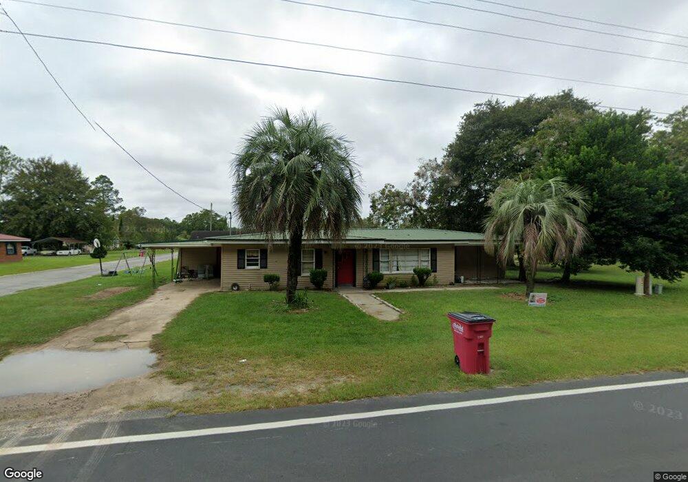
This home is located at 321 Radio Station Rd, Alma, GA 31510 and is currently estimated at $122,024, approximately $60 per square foot. 321 Radio Station Rd is a home located in Bacon County with nearby schools including Bacon County Primary School, Bacon County Elementary School, and Bacon County Middle School.
Ownership History
Date
Name
Owned For
Owner Type
Purchase Details
Closed on
May 15, 2023
Sold by
Matthews Marcy
Bought by
Campbell Patrick
Current Estimated Value
Purchase Details
Closed on
Jan 15, 2020
Sold by
Newrez Llc
Bought by
Mcdonald Marcey
Purchase Details
Closed on
Oct 1, 2019
Sold by
Taylor Carlos Leon
Bought by
Newrez Llc
Purchase Details
Closed on
Jul 28, 2015
Sold by
Cantrell Connie
Bought by
Taylor Carlos Leon
Home Financials for this Owner
Home Financials are based on the most recent Mortgage that was taken out on this home.
Original Mortgage
$53,571
Interest Rate
4.11%
Mortgage Type
New Conventional
Purchase Details
Closed on
Jan 23, 2014
Sold by
Cantrell Harold
Bought by
Cantrell Connie T
Purchase Details
Closed on
Mar 3, 2003
Sold by
Patterson Alyce and Genelle Sweet
Bought by
Cantrell Harold J
Purchase Details
Closed on
Oct 5, 1990
Bought by
Sweet Genelle W
Create a Home Valuation Report for This Property
The Home Valuation Report is an in-depth analysis detailing your home's value as well as a comparison with similar homes in the area
Home Values in the Area
Average Home Value in this Area
Purchase History
| Date | Buyer | Sale Price | Title Company |
|---|---|---|---|
| Campbell Patrick | -- | -- | |
| Mcdonald Marcey | $36,900 | -- | |
| Newrez Llc | $24,960 | -- | |
| Taylor Carlos Leon | $52,500 | -- | |
| Cantrell Connie T | -- | -- | |
| Cantrell Harold J | $43,000 | -- | |
| Sweet Genelle W | $32,000 | -- |
Source: Public Records
Mortgage History
| Date | Status | Borrower | Loan Amount |
|---|---|---|---|
| Previous Owner | Taylor Carlos Leon | $53,571 |
Source: Public Records
Tax History Compared to Growth
Tax History
| Year | Tax Paid | Tax Assessment Tax Assessment Total Assessment is a certain percentage of the fair market value that is determined by local assessors to be the total taxable value of land and additions on the property. | Land | Improvement |
|---|---|---|---|---|
| 2024 | $1,152 | $31,704 | $1,760 | $29,944 |
| 2023 | $1,100 | $28,544 | $1,760 | $26,784 |
| 2022 | $767 | $19,904 | $1,600 | $18,304 |
| 2021 | $569 | $19,824 | $1,600 | $18,224 |
| 2020 | $744 | $18,468 | $1,600 | $16,868 |
| 2019 | $540 | $18,468 | $1,600 | $16,868 |
| 2018 | $532 | $18,317 | $1,600 | $16,717 |
| 2017 | $738 | $18,317 | $1,600 | $16,717 |
| 2016 | $533 | $18,317 | $1,600 | $16,717 |
| 2015 | $752 | $18,658 | $1,821 | $16,838 |
| 2014 | $650 | $18,658 | $1,821 | $16,838 |
| 2013 | $650 | $17,888 | $1,820 | $16,067 |
Source: Public Records
Map
Nearby Homes
- 611 S Bead St
- 403 S Ware St
- 117 Grace Loop Unit 1
- 118 Grace Loop Unit 1
- 122 Grace Loop Unit 1
- 314 W 16th St
- 9TH E 417
- 113 Brite Blue Dr
- 198 Meadow Rd
- 166 Grace Loop Unit 1
- 907 N Pierce St
- 401 Lee St
- 0 Oriole Rd Unit 1654653
- 0 Oriole Rd Unit 10543585
- 0 Oriole Rd Unit 25773381
- 0 Oriole Rd Unit 160930
- 224 Meadow Rd
- 1348 U S 1
- 118 Morris Dr
- 1109 W 4th Street Extension
- 401 Radio Station Rd
- 317 Radio Station Rd
- 128 Crosby Rd
- 124 Crosby Rd
- 401 Williams St
- 403 Radio Station Rd
- 315 Radio Station Rd
- 122 Crosby Rd
- 313 Radio Station Rd
- 201 Crosby Rd
- 125 Crosby Rd
- 127 Crosby Rd
- 203 Crosby Rd
- 405 Radio Station Rd
- 120 Crosby Rd
- 107 Mccrea Ave
- 311 Radio Station Rd
- 109 Mccrea Ave
- 118 Crosby Rd
- 310 Radio Station Rd