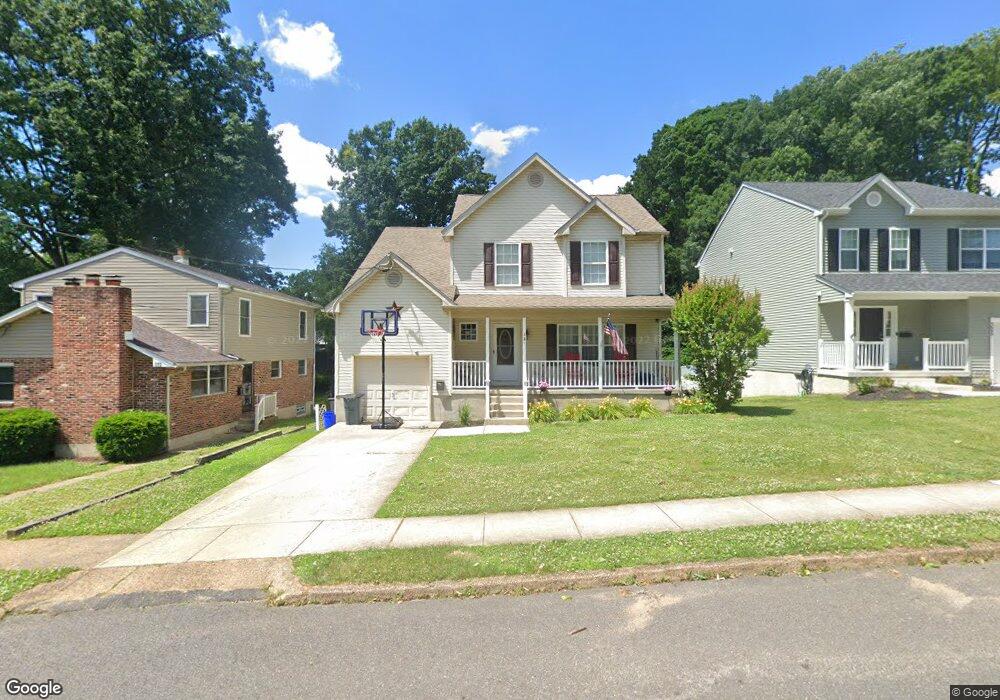
321 Union Ave Runnemede, NJ 08078
Estimated Value: $352,000 - $426,000
4
Beds
3
Baths
1,850
Sq Ft
$213/Sq Ft
Est. Value
About This Home
This home is located at 321 Union Ave, Runnemede, NJ 08078 and is currently estimated at $393,569, approximately $212 per square foot. 321 Union Ave is a home located in Camden County with nearby schools including Mary E. Volz Elementary School, Downing Elementary School, and Triton High School.
Ownership History
Date
Name
Owned For
Owner Type
Purchase Details
Closed on
Oct 31, 2008
Sold by
Family 5 Homes And Custom Buuilders In
Bought by
Worrell Timothy J and Worrell Jennifer R
Current Estimated Value
Home Financials for this Owner
Home Financials are based on the most recent Mortgage that was taken out on this home.
Original Mortgage
$225,000
Outstanding Balance
$148,060
Interest Rate
6.13%
Mortgage Type
New Conventional
Estimated Equity
$245,509
Purchase Details
Closed on
Oct 7, 2008
Sold by
Chain Anna M and Vartebedian John R
Bought by
Family 5 Homes And Custom Buildes Inc
Home Financials for this Owner
Home Financials are based on the most recent Mortgage that was taken out on this home.
Original Mortgage
$225,000
Outstanding Balance
$148,060
Interest Rate
6.13%
Mortgage Type
New Conventional
Estimated Equity
$245,509
Purchase Details
Closed on
Oct 18, 2006
Sold by
Dorothy Nolan Est Of
Bought by
Chain Anna M and Vartebedian John R
Create a Home Valuation Report for This Property
The Home Valuation Report is an in-depth analysis detailing your home's value as well as a comparison with similar homes in the area
Home Values in the Area
Average Home Value in this Area
Purchase History
| Date | Buyer | Sale Price | Title Company |
|---|---|---|---|
| Worrell Timothy J | $255,000 | -- | |
| Family 5 Homes And Custom Buildes Inc | -- | -- | |
| Chain Anna M | $50,000 | -- |
Source: Public Records
Mortgage History
| Date | Status | Borrower | Loan Amount |
|---|---|---|---|
| Open | Worrell Timothy J | $225,000 | |
| Closed | Family 5 Homes And Custom Buildes Inc | $225,000 |
Source: Public Records
Tax History
| Year | Tax Paid | Tax Assessment Tax Assessment Total Assessment is a certain percentage of the fair market value that is determined by local assessors to be the total taxable value of land and additions on the property. | Land | Improvement |
|---|---|---|---|---|
| 2025 | $8,480 | $188,200 | $45,000 | $143,200 |
| 2024 | $8,222 | $188,200 | $45,000 | $143,200 |
| 2023 | $8,222 | $188,200 | $45,000 | $143,200 |
| 2022 | $7,961 | $188,200 | $45,000 | $143,200 |
| 2021 | $7,773 | $188,200 | $45,000 | $143,200 |
| 2020 | $7,696 | $188,200 | $45,000 | $143,200 |
| 2019 | $7,554 | $188,200 | $45,000 | $143,200 |
| 2018 | $7,409 | $188,200 | $45,000 | $143,200 |
| 2017 | $7,219 | $188,200 | $45,000 | $143,200 |
| 2016 | $7,129 | $188,200 | $45,000 | $143,200 |
| 2015 | $7,150 | $188,200 | $45,000 | $143,200 |
| 2014 | $7,058 | $188,200 | $45,000 | $143,200 |
Source: Public Records
Map
Nearby Homes
Your Personal Tour Guide
Ask me questions while you tour the home.