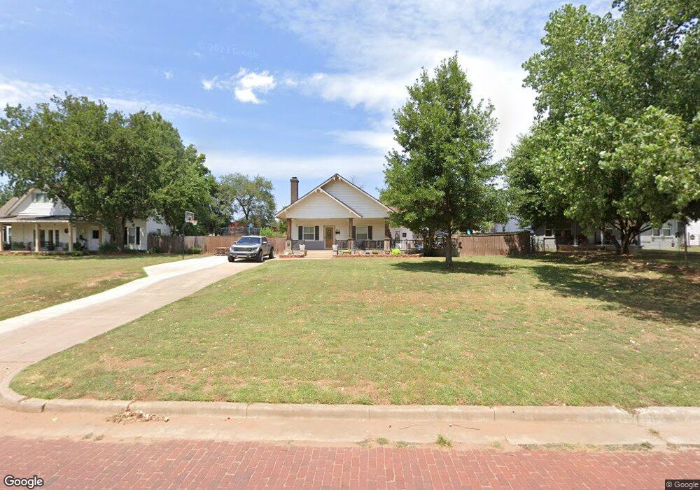
321 W Adams St Purcell, OK 73080
Estimated Value: $161,000 - $183,000
2
Beds
2
Baths
1,474
Sq Ft
$117/Sq Ft
Est. Value
About This Home
This home is located at 321 W Adams St, Purcell, OK 73080 and is currently estimated at $173,002, approximately $117 per square foot. 321 W Adams St is a home located in McClain County with nearby schools including Purcell Elementary School, Purcell Intermediate School, and Purcell Junior High School.
Ownership History
Date
Name
Owned For
Owner Type
Purchase Details
Closed on
May 2, 2007
Sold by
Cowell Richard C and Cowell Donna Lee
Bought by
Dobbins Argo Derrick and Dobbins Kendra Alise
Current Estimated Value
Home Financials for this Owner
Home Financials are based on the most recent Mortgage that was taken out on this home.
Original Mortgage
$86,640
Outstanding Balance
$52,585
Interest Rate
6.13%
Mortgage Type
FHA
Estimated Equity
$120,417
Purchase Details
Closed on
Mar 16, 1998
Sold by
Vernon Turner
Bought by
Richard and Onna Cowell
Create a Home Valuation Report for This Property
The Home Valuation Report is an in-depth analysis detailing your home's value as well as a comparison with similar homes in the area
Home Values in the Area
Average Home Value in this Area
Purchase History
| Date | Buyer | Sale Price | Title Company |
|---|---|---|---|
| Dobbins Argo Derrick | $88,000 | None Available | |
| Richard | $55,500 | -- |
Source: Public Records
Mortgage History
| Date | Status | Borrower | Loan Amount |
|---|---|---|---|
| Open | Dobbins Argo Derrick | $86,640 |
Source: Public Records
Tax History Compared to Growth
Tax History
| Year | Tax Paid | Tax Assessment Tax Assessment Total Assessment is a certain percentage of the fair market value that is determined by local assessors to be the total taxable value of land and additions on the property. | Land | Improvement |
|---|---|---|---|---|
| 2024 | $1,242 | $11,431 | $2,110 | $9,321 |
| 2023 | $1,242 | $10,886 | $1,676 | $9,210 |
| 2022 | $1,113 | $10,368 | $1,375 | $8,993 |
| 2021 | $1,074 | $9,882 | $1,375 | $8,507 |
| 2020 | $1,045 | $9,709 | $1,375 | $8,334 |
| 2019 | $1,131 | $10,315 | $1,322 | $8,993 |
| 2018 | $1,067 | $9,824 | $1,250 | $8,574 |
| 2017 | $993 | $9,356 | $1,358 | $7,998 |
| 2016 | $958 | $8,911 | $990 | $7,921 |
| 2015 | $957 | $8,763 | $990 | $7,773 |
| 2014 | $958 | $8,865 | $990 | $7,875 |
Source: Public Records
Map
Nearby Homes
- 0 State Highway 74
- 621 N 2nd Ave
- 300 W Monroe St
- 0000 Jackson St
- 24956 Norte Rd
- 628 W Main St
- 515 W Jackson St
- 124 W Brule St
- 515 S Lester Ln
- 819 W Adams St
- 302 W Harrison St
- 104 W Comanche St
- 517 Bob White Dr
- 200 E Van Buren St
- 1228 S Brook Dr
- 1229 Meadow Brook Dr
- 1225 Meadow Brook Dr
- 1213 Meadow Brook Dr
- 1217 Meadow Brook Dr
- 832 W Adams St
- 315 W Adams St
- 327 W Adams St
- 327 W Adams St
- 311 W Adams St
- 303 W Adams St
- 316 W Adams St
- 328 W Adams St
- 306 W Adams St
- 319 N 4th Ave
- 229 W Adams St
- 327 N 4th Ave
- 208 N 4th Ave
- 319 W Jefferson St
- 313 W Jefferson St
- 331 W Jefferson St
- 230 W Jefferson St
- 309 W Jefferson St
- 319 W Washington St
- 319 W Washington St
- 319 W Washington St