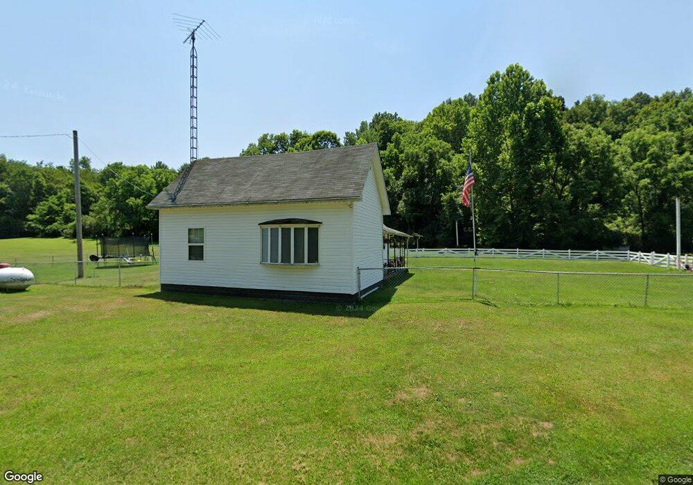
32106 State Route 325 Langsville, OH 45741
Estimated Value: $97,000 - $152,000
2
Beds
2
Baths
1,121
Sq Ft
$113/Sq Ft
Est. Value
About This Home
This home is located at 32106 State Route 325, Langsville, OH 45741 and is currently estimated at $126,660, approximately $112 per square foot. 32106 State Route 325 is a home located in Meigs County with nearby schools including Meigs Primary School, Meigs Intermediate School, and Meigs Middle School.
Ownership History
Date
Name
Owned For
Owner Type
Purchase Details
Closed on
Mar 28, 2011
Sold by
Gorby Ronnie W and Gorby Pauline L
Bought by
Fetty Jeremy L and Fetty Richard L
Current Estimated Value
Home Financials for this Owner
Home Financials are based on the most recent Mortgage that was taken out on this home.
Original Mortgage
$53,749
Outstanding Balance
$37,410
Interest Rate
4.99%
Mortgage Type
Purchase Money Mortgage
Estimated Equity
$89,250
Create a Home Valuation Report for This Property
The Home Valuation Report is an in-depth analysis detailing your home's value as well as a comparison with similar homes in the area
Home Values in the Area
Average Home Value in this Area
Purchase History
| Date | Buyer | Sale Price | Title Company |
|---|---|---|---|
| Fetty Jeremy L | $55,000 | None Available |
Source: Public Records
Mortgage History
| Date | Status | Borrower | Loan Amount |
|---|---|---|---|
| Open | Fetty Jeremy L | $53,749 |
Source: Public Records
Tax History Compared to Growth
Tax History
| Year | Tax Paid | Tax Assessment Tax Assessment Total Assessment is a certain percentage of the fair market value that is determined by local assessors to be the total taxable value of land and additions on the property. | Land | Improvement |
|---|---|---|---|---|
| 2024 | $875 | $27,280 | $7,930 | $19,350 |
| 2023 | $875 | $27,280 | $7,930 | $19,350 |
| 2022 | $919 | $27,280 | $7,930 | $19,350 |
| 2021 | $771 | $19,370 | $6,180 | $13,190 |
| 2020 | $716 | $19,370 | $6,180 | $13,190 |
| 2019 | $707 | $19,370 | $6,180 | $13,190 |
| 2018 | $553 | $15,320 | $3,760 | $11,560 |
| 2017 | $553 | $15,320 | $3,760 | $11,560 |
| 2016 | $548 | $15,320 | $3,760 | $11,560 |
| 2014 | $502 | $15,200 | $3,760 | $11,440 |
| 2013 | $502 | $15,200 | $3,760 | $11,440 |
Source: Public Records
Map
Nearby Homes
- 0 Briar Ridge Rd Unit 11566708
- 0 Briar Ridge Rd Unit 24580053
- 0 Briar Ridge Rd Unit 24580050
- 32254 Titus Rd
- 32254 Titus Rd Unit (Tract 2 at Titus)
- 32204 Titus Rd
- 32204 Titus Rd Unit (GV Cabin at Titus)
- 30286 Briar Ridge Rd
- 0 Briar Ridge Rd Unit 11562403
- 31428 Will Vance Rd
- 0 Will Vance Rd Unit 23777611
- 33062 Dexter Rd
- 0 Parkinson Rd Unit (Tract 8 at Titus)
- 0 Parkinson Rd Unit 21532380
- 31566 Parker Run Rd
- 32319 Red Hill Rd Unit (Overlook Cabin at B
- 31845 Red Hill Rd
- 0 Red Hill Rd Unit 22347212
- 32325 Red Hill Rd Unit (Phase I Tract 1A Bi
- 31152 Edmundson Rd
- 32106 State Route 325
- 0 N Side State Rd 325
- 30777 State Route 325
- 30951 State Route 325
- 30945 State Route 325
- 30969 State Route 325
- 30981 State Route 325
- 30997 State Route 325
- 31003 State Route 325
- 31908 Briar Ridge Rd
- 30745 State Route 325
- 31894 Briar Ridge Rd
- 31850 Briar Ridge Rd
- 31855 Briar Ridge Rd
- 124 Sr
- 31510 State Route 124
- 31423 State Route 124
- 31423 State Route 124
- 32053 State Route 124
- 31771 State Route 325