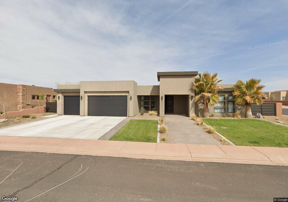
3211 S Red Sands Way Unit 124 Hurricane, UT 84737
Sand Hollow Resort NeighborhoodEstimated Value: $634,000 - $754,000
4
Beds
3
Baths
2,173
Sq Ft
$323/Sq Ft
Est. Value
About This Home
This home is located at 3211 S Red Sands Way Unit 124, Hurricane, UT 84737 and is currently estimated at $700,966, approximately $322 per square foot. 3211 S Red Sands Way Unit 124 is a home located in Washington County with nearby schools including Hurricane Middle School, Hurricane High School, and Three Falls School.
Ownership History
Date
Name
Owned For
Owner Type
Purchase Details
Closed on
Jan 24, 2022
Sold by
Garr and Taelyn
Bought by
Desert Summit Properties Llc
Current Estimated Value
Purchase Details
Closed on
Jan 14, 2022
Sold by
Garr and Taelyn
Bought by
Desert Summit Properties Llc
Purchase Details
Closed on
Jul 21, 2020
Sold by
Red Rock Real Estate Holding Llc
Bought by
Garr Brody and Gleason Taelyn
Purchase Details
Closed on
May 17, 2017
Sold by
Dunes Real Estate Inc
Bought by
Red Rock Real Estate Holding Llc
Purchase Details
Closed on
Dec 31, 2008
Sold by
Sand Hollow Development Group Llc
Bought by
Dunes Real Estate Inc
Create a Home Valuation Report for This Property
The Home Valuation Report is an in-depth analysis detailing your home's value as well as a comparison with similar homes in the area
Home Values in the Area
Average Home Value in this Area
Purchase History
| Date | Buyer | Sale Price | Title Company |
|---|---|---|---|
| Desert Summit Properties Llc | -- | None Listed On Document | |
| Desert Summit Properties Llc | -- | None Listed On Document | |
| Garr Brody | -- | Southern Utah Title Co | |
| Red Rock Real Estate Holding Llc | -- | None Available | |
| Dunes Real Estate Inc | -- | Juab Title & Abstract Co |
Source: Public Records
Tax History Compared to Growth
Tax History
| Year | Tax Paid | Tax Assessment Tax Assessment Total Assessment is a certain percentage of the fair market value that is determined by local assessors to be the total taxable value of land and additions on the property. | Land | Improvement |
|---|---|---|---|---|
| 2025 | $2,691 | $360,195 | $110,000 | $250,195 |
| 2023 | $2,968 | $398,145 | $110,000 | $288,145 |
| 2022 | $2,943 | $673,000 | $170,000 | $503,000 |
| 2021 | $685 | $70,000 | $70,000 | $0 |
| 2020 | $324 | $70,000 | $70,000 | $0 |
| 2019 | $755 | $70,000 | $70,000 | $0 |
| 2018 | $808 | $70,000 | $0 | $0 |
| 2017 | $840 | $70,000 | $0 | $0 |
| 2016 | $805 | $65,000 | $0 | $0 |
| 2015 | $836 | $65,000 | $0 | $0 |
| 2014 | $741 | $60,000 | $0 | $0 |
Source: Public Records
Map
Nearby Homes
- 3214 S Red Sands Way
- 3208 S Sandstone Dr
- 3243 S Sand Stone Dr
- 3243 S Sandstone Dr
- 3257 S Drifting Dunes Ln
- Lot #12 S Endless Trail
- 0 S Endless Trail Unit LOT 15 2091998
- 0 S Endless Trail Unit 25-262220
- 0 S Endless Trail Unit 25-264815
- LOT 23 S Endless Trail
- 3236 S Cottontail Cir
- LOT 22 S Endless Trail
- 5627 W Desert Dream
- 3325 S Red Rock Way
- Legacy Casita #2914 Plan at Sand Hollow - The Estates
- Regal #2912 Plan at Sand Hollow - The Estates
- Legacy #2914 Plan at Sand Hollow - The Estates
- Aspen #2911 Plan at Sand Hollow - The Estates
- 5310 W 3180 S
- 5496 W Sand Ridge Dr
- 3211 S Red Sands Way
- 3203 S Red Sands Way
- Lot #159 the Dunes Subdivision
- 5468 W Copper Cliffs Way
- 5476 W Copper Cliffs Way
- Lot 122 Dunes at Sand Hollow
- 3225 S Red Sands Way
- 0 Way
- 0 S Red Sands Way Unit 15-168256
- 0 S Red Sands Way Unit 15-168260
- 0 S Red Sands Way Unit 15-168310
- 0 S Red Sands Way Unit 18-199205
- 0 S Red Sands Way Unit 16-181161
- 0 S Red Sands Way Unit 12-135461
- 0 S Red Sands Way Unit 19-202332
- 0 S Red Sands Way Unit 22-228898
- 0 S Red Sands Way Unit 20-216786
- 0 S Red Sands Way Unit 19-202929
- 0 S Red Sands Way Unit 19-202331
- 0 S Red Sands Way Unit 18-199758