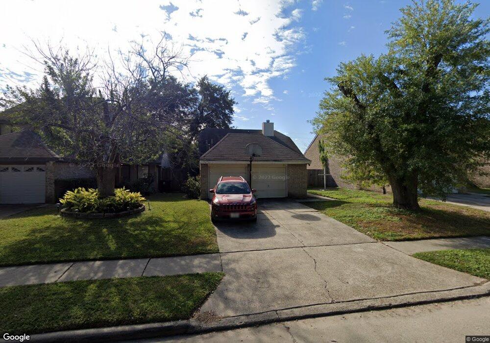
3211 Vega St Houston, TX 77088
Greater Inwood NeighborhoodEstimated Value: $215,000 - $233,000
3
Beds
2
Baths
1,800
Sq Ft
$124/Sq Ft
Est. Value
About This Home
This home is located at 3211 Vega St, Houston, TX 77088 and is currently estimated at $222,375, approximately $123 per square foot. 3211 Vega St is a home located in Harris County with nearby schools including Stovall School, Caraway Intermediate School, and Caraway Elementary School.
Ownership History
Date
Name
Owned For
Owner Type
Purchase Details
Closed on
Feb 13, 2007
Sold by
Spoonts Mark and Spoonts Sara Cassandra
Bought by
Mcgowen Curtis L
Current Estimated Value
Home Financials for this Owner
Home Financials are based on the most recent Mortgage that was taken out on this home.
Original Mortgage
$105,470
Outstanding Balance
$63,067
Interest Rate
6.13%
Mortgage Type
Purchase Money Mortgage
Estimated Equity
$159,308
Purchase Details
Closed on
May 2, 2006
Sold by
Thompson George Anthony
Bought by
Spoonts Mark
Create a Home Valuation Report for This Property
The Home Valuation Report is an in-depth analysis detailing your home's value as well as a comparison with similar homes in the area
Home Values in the Area
Average Home Value in this Area
Purchase History
| Date | Buyer | Sale Price | Title Company |
|---|---|---|---|
| Mcgowen Curtis L | -- | Commonwealth Title | |
| Spoonts Mark | $61,600 | None Available |
Source: Public Records
Mortgage History
| Date | Status | Borrower | Loan Amount |
|---|---|---|---|
| Open | Mcgowen Curtis L | $105,470 |
Source: Public Records
Tax History Compared to Growth
Tax History
| Year | Tax Paid | Tax Assessment Tax Assessment Total Assessment is a certain percentage of the fair market value that is determined by local assessors to be the total taxable value of land and additions on the property. | Land | Improvement |
|---|---|---|---|---|
| 2025 | $13 | $199,658 | $40,028 | $159,630 |
| 2024 | $13 | $199,658 | $40,028 | $159,630 |
| 2023 | $13 | $207,575 | $45,900 | $161,675 |
| 2022 | $3,244 | $176,535 | $30,600 | $145,935 |
| 2021 | $3,089 | $138,738 | $21,165 | $117,573 |
| 2020 | $2,951 | $140,838 | $21,165 | $119,673 |
| 2019 | $2,812 | $128,738 | $13,260 | $115,478 |
| 2018 | $680 | $118,706 | $13,260 | $105,446 |
| 2017 | $2,228 | $118,706 | $13,260 | $105,446 |
| 2016 | $2,025 | $111,688 | $13,260 | $98,428 |
| 2015 | $619 | $100,037 | $13,260 | $86,777 |
| 2014 | $619 | $66,083 | $13,260 | $52,823 |
Source: Public Records
Map
Nearby Homes
- 0 Dollywright St Unit 49022715
- 0 Glenn Unit 90901807
- 2923 Ellington St
- 0 No St Unit 72514436
- 0 Irby St Unit 85919049
- 1907 Willow
- 0 Irby St Unit 79686567
- 0 Parkes St Unit 20740904
- 0 Observatory St Unit 64457412
- 2672 Victory Dr
- 8814 Woodcamp Dr
- 8510 Woodcamp Dr
- 3201 Stallings Dr
- 8518 Wild Basin Dr
- 7800 Sand St
- 2722 Stallings Dr
- 2819 Rigel Rd
- 10009 Lonallen St
- 2722 Vega St
- 0 Genemaury St