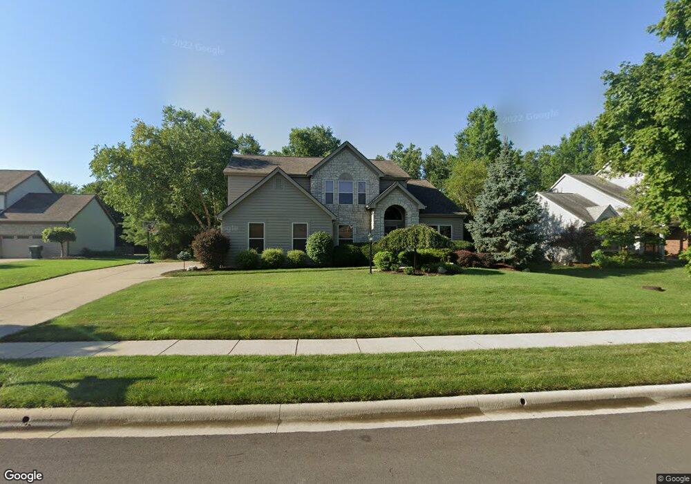
3215 Brentwood Ct Powell, OH 43065
Liberty Township NeighborhoodEstimated Value: $548,000 - $590,000
3
Beds
3
Baths
2,592
Sq Ft
$221/Sq Ft
Est. Value
About This Home
This home is located at 3215 Brentwood Ct, Powell, OH 43065 and is currently estimated at $572,536, approximately $220 per square foot. 3215 Brentwood Ct is a home located in Delaware County with nearby schools including Tyler Run Elementary School, Olentangy Liberty Middle School, and Olentangy Liberty High School.
Ownership History
Date
Name
Owned For
Owner Type
Purchase Details
Closed on
Nov 4, 1997
Sold by
Joshua Investment Co
Bought by
Newton Kathleen S and Newton John W
Current Estimated Value
Home Financials for this Owner
Home Financials are based on the most recent Mortgage that was taken out on this home.
Original Mortgage
$210,000
Interest Rate
7.51%
Mortgage Type
New Conventional
Create a Home Valuation Report for This Property
The Home Valuation Report is an in-depth analysis detailing your home's value as well as a comparison with similar homes in the area
Home Values in the Area
Average Home Value in this Area
Purchase History
| Date | Buyer | Sale Price | Title Company |
|---|---|---|---|
| Newton Kathleen S | $271,190 | -- |
Source: Public Records
Mortgage History
| Date | Status | Borrower | Loan Amount |
|---|---|---|---|
| Closed | Newton Kathleen S | $210,000 |
Source: Public Records
Tax History Compared to Growth
Tax History
| Year | Tax Paid | Tax Assessment Tax Assessment Total Assessment is a certain percentage of the fair market value that is determined by local assessors to be the total taxable value of land and additions on the property. | Land | Improvement |
|---|---|---|---|---|
| 2024 | $8,803 | $168,000 | $34,370 | $133,630 |
| 2023 | $8,745 | $166,250 | $34,370 | $131,880 |
| 2022 | $8,244 | $124,260 | $23,910 | $100,350 |
| 2021 | $8,294 | $124,260 | $23,910 | $100,350 |
| 2020 | $8,334 | $124,260 | $23,910 | $100,350 |
| 2019 | $7,350 | $114,250 | $23,910 | $90,340 |
| 2018 | $7,385 | $114,250 | $23,910 | $90,340 |
| 2017 | $7,307 | $104,970 | $21,390 | $83,580 |
| 2016 | $7,222 | $104,970 | $21,390 | $83,580 |
| 2015 | $6,531 | $104,970 | $21,390 | $83,580 |
| 2014 | $6,621 | $104,970 | $21,390 | $83,580 |
| 2013 | $6,616 | $102,520 | $21,390 | $81,130 |
Source: Public Records
Map
Nearby Homes
- 2961 Lexington Dr
- 91 Tiller Dr
- 8803 Yates Point Ct
- 8796 Yates Point Ct
- 55 Timber Oak Ct
- 2168 Summit Row Blvd
- 1890 Gallo Dr
- 274 Stamford Dr
- 2013 Summit Row Blvd
- 261 Andover Dr
- 8741 Jamey Ct
- 2228 Gnarled Pine Dr
- 1949 Hamrock Dr
- 2672 Sawmill Reserve Dr Unit 2672
- 524 Commons Dr Unit 524
- 8632 Copperview Dr
- 10586 Churchill Dr
- 8345 Smoky Row Rd Unit 8345
- 1937 Liberty St
- 2020 Liberty St
- 3237 Brentwood Ct
- 3195 Brentwood Ct
- 3255 Brentwood Ct
- 3212 Brentwood Ct
- 3196 Brentwood Ct
- 3179 Brentwood Ct
- 3273 Brentwood Ct
- 3172 Brentwood Ct
- 3178 Brentwood Ct
- 3254 Brentwood Ct
- 3291 Brentwood Ct
- 3272 Brentwood Ct
- 3294 Brentwood Ct
- 3309 Brentwood Ct
- 10511 Torrington Dr
- 3155 Ardmore Ct
- 10516 Torrington Dr
- 3245 Camden Ct
- 3329 Brentwood Ct
- 3308 Brentwood Ct