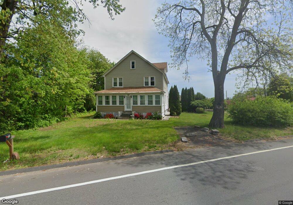
322 Amostown Rd West Springfield, MA 01089
Estimated Value: $369,023 - $429,000
4
Beds
2
Baths
1,972
Sq Ft
$203/Sq Ft
Est. Value
About This Home
This home is located at 322 Amostown Rd, West Springfield, MA 01089 and is currently estimated at $401,256, approximately $203 per square foot. 322 Amostown Rd is a home located in Hampden County with nearby schools including Hampden Charter School of Science West and St Thomas The Apostle School.
Ownership History
Date
Name
Owned For
Owner Type
Purchase Details
Closed on
May 7, 2010
Sold by
Flouton Timothy V
Bought by
Patel Aswin C and Patel Chirag A
Current Estimated Value
Home Financials for this Owner
Home Financials are based on the most recent Mortgage that was taken out on this home.
Original Mortgage
$125,000
Outstanding Balance
$83,700
Interest Rate
5.03%
Mortgage Type
Purchase Money Mortgage
Estimated Equity
$317,556
Purchase Details
Closed on
Dec 30, 2009
Sold by
Bonavita Peter
Bought by
Flouton Timothy
Purchase Details
Closed on
Jul 20, 2006
Sold by
Flouton Timothy V
Bought by
Bonavita Peter
Home Financials for this Owner
Home Financials are based on the most recent Mortgage that was taken out on this home.
Original Mortgage
$248,500
Interest Rate
6.67%
Mortgage Type
Purchase Money Mortgage
Purchase Details
Closed on
Nov 1, 2005
Sold by
Burowicz Clara and Hershowitz David
Bought by
Flouton Timothy
Create a Home Valuation Report for This Property
The Home Valuation Report is an in-depth analysis detailing your home's value as well as a comparison with similar homes in the area
Home Values in the Area
Average Home Value in this Area
Purchase History
| Date | Buyer | Sale Price | Title Company |
|---|---|---|---|
| Patel Aswin C | $192,500 | -- | |
| Flouton Timothy | $248,500 | -- | |
| Bonavita Peter | $248,500 | -- | |
| Flouton Timothy | $117,100 | -- |
Source: Public Records
Mortgage History
| Date | Status | Borrower | Loan Amount |
|---|---|---|---|
| Open | Patel Aswin C | $125,000 | |
| Previous Owner | Bonavita Peter | $248,500 |
Source: Public Records
Tax History Compared to Growth
Tax History
| Year | Tax Paid | Tax Assessment Tax Assessment Total Assessment is a certain percentage of the fair market value that is determined by local assessors to be the total taxable value of land and additions on the property. | Land | Improvement |
|---|---|---|---|---|
| 2025 | $4,888 | $328,700 | $114,200 | $214,500 |
| 2024 | $4,591 | $310,000 | $114,200 | $195,800 |
| 2023 | $4,343 | $279,500 | $114,200 | $165,300 |
| 2022 | $3,918 | $248,600 | $103,700 | $144,900 |
| 2021 | $3,579 | $211,800 | $82,700 | $129,100 |
| 2020 | $3,605 | $212,200 | $82,700 | $129,500 |
| 2019 | $3,599 | $212,200 | $82,700 | $129,500 |
| 2018 | $3,618 | $212,200 | $82,700 | $129,500 |
| 2017 | $3,618 | $212,200 | $82,700 | $129,500 |
| 2016 | $3,495 | $205,700 | $77,700 | $128,000 |
| 2015 | $3,429 | $201,800 | $76,200 | $125,600 |
| 2014 | $815 | $201,800 | $76,200 | $125,600 |
Source: Public Records
Map
Nearby Homes
- 122 Chester St
- 139 Lincoln St
- 129 Lincoln St
- 123 Chester St
- 315 Amostown Rd
- 340 Amostown Rd
- 121 Lincoln St
- 305 Amostown Rd
- 333 Amostown Rd
- 111 Chester St
- 108 Chester St
- 38 Lower Mass Ave
- 111 Lincoln St
- 138 Lincoln St
- 132 Lincoln St
- 144 Lincoln St
- 124 Lincoln St
- 152 Lincoln St
- 270 Amostown Rd
- 103 Chester St