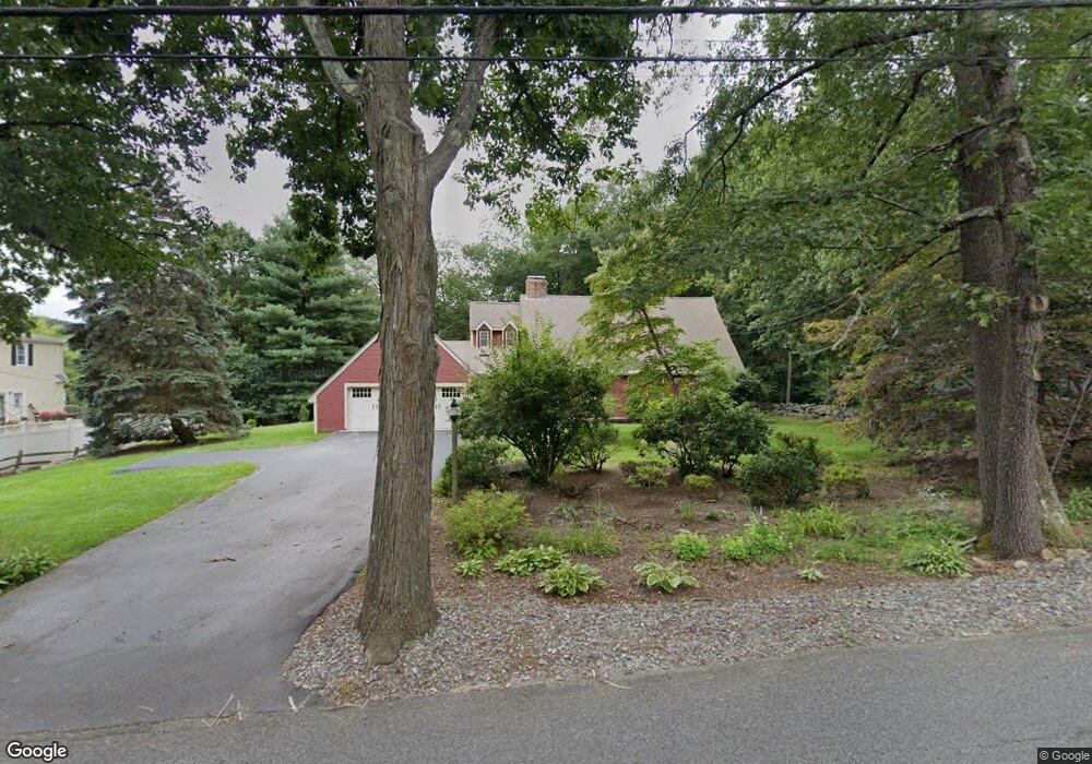
322 Spring St Shrewsbury, MA 01545
Estimated Value: $855,000 - $937,000
3
Beds
2
Baths
2,474
Sq Ft
$355/Sq Ft
Est. Value
About This Home
This home is located at 322 Spring St, Shrewsbury, MA 01545 and is currently estimated at $877,162, approximately $354 per square foot. 322 Spring St is a home located in Worcester County with nearby schools including Spring Street Elementary School, Sherwood Middle School, and Oak Middle School.
Ownership History
Date
Name
Owned For
Owner Type
Purchase Details
Closed on
Nov 10, 2014
Sold by
Baptist Marilyn M
Bought by
322 Spring Street Irt and Karlstad
Current Estimated Value
Purchase Details
Closed on
Dec 17, 1991
Sold by
Dagostine Julian J
Bought by
Baybank
Purchase Details
Closed on
Nov 18, 1983
Bought by
322 Spring St Irt and Karlstad, Robert C
Create a Home Valuation Report for This Property
The Home Valuation Report is an in-depth analysis detailing your home's value as well as a comparison with similar homes in the area
Home Values in the Area
Average Home Value in this Area
Purchase History
| Date | Buyer | Sale Price | Title Company |
|---|---|---|---|
| 322 Spring Street Irt | -- | -- | |
| 322 Spring Street Irt | -- | -- | |
| 322 Spring Street Irt | -- | -- | |
| Baybank | $19,500 | -- | |
| Baybank | $19,500 | -- | |
| Baybank | $19,500 | -- | |
| 322 Spring St Irt | $37,000 | -- |
Source: Public Records
Mortgage History
| Date | Status | Borrower | Loan Amount |
|---|---|---|---|
| Previous Owner | 322 Spring St Irt | $54,000 | |
| Previous Owner | 322 Spring St Irt | $120,000 |
Source: Public Records
Tax History Compared to Growth
Tax History
| Year | Tax Paid | Tax Assessment Tax Assessment Total Assessment is a certain percentage of the fair market value that is determined by local assessors to be the total taxable value of land and additions on the property. | Land | Improvement |
|---|---|---|---|---|
| 2025 | $90 | $751,400 | $293,600 | $457,800 |
| 2024 | $8,493 | $686,000 | $279,600 | $406,400 |
| 2023 | $8,048 | $613,400 | $279,600 | $333,800 |
| 2022 | $8,346 | $591,500 | $248,500 | $343,000 |
| 2021 | $7,231 | $548,200 | $248,500 | $299,700 |
| 2020 | $6,836 | $548,200 | $248,500 | $299,700 |
| 2019 | $6,725 | $535,000 | $239,400 | $295,600 |
| 2018 | $6,246 | $493,400 | $221,000 | $272,400 |
| 2017 | $6,081 | $474,000 | $201,600 | $272,400 |
| 2016 | $6,105 | $469,600 | $190,500 | $279,100 |
| 2015 | $5,734 | $434,400 | $170,200 | $264,200 |
Source: Public Records
Map
Nearby Homes
- 2 Meadowbrook Cir
- 318 Spring St
- 4 Meadowbrook Cir
- 321 Spring St
- 308 Spring St
- 6 Meadowbrook Cir
- 325 Spring St
- 315 Spring St
- 342 Spring St
- 5 Meadowbrook Cir
- 3 Meadowbrook Cir
- 331 Spring St
- 331 Spring St Unit 331
- 303 Spring St
- 8 Meadowbrook Cir
- 327 Spring St
- 298 Spring St
- 352 Spring St
- 351 Spring St
- 365 Spring St