Estimated Value: $99,965 - $295,000
--
Bed
2
Baths
768
Sq Ft
$242/Sq Ft
Est. Value
About This Home
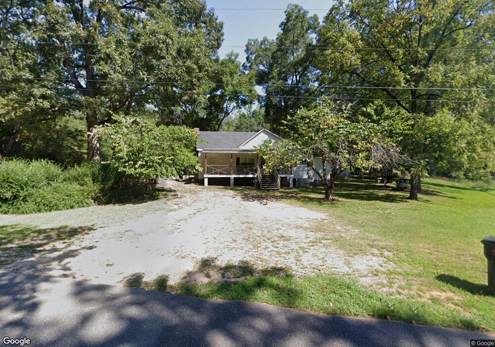
This home is located at 323 Paul Smith Rd, Hull, GA 30646 and is currently estimated at $185,741, approximately $241 per square foot. 323 Paul Smith Rd is a home located in Madison County with nearby schools including Madison County High School.
Ownership History
Date
Name
Owned For
Owner Type
Purchase Details
Closed on
Aug 7, 2012
Sold by
Moore Paulette Smith
Bought by
Moore Derek W
Current Estimated Value
Home Financials for this Owner
Home Financials are based on the most recent Mortgage that was taken out on this home.
Original Mortgage
$44,184
Outstanding Balance
$30,435
Interest Rate
3.55%
Mortgage Type
FHA
Estimated Equity
$155,306
Purchase Details
Closed on
Mar 21, 2001
Sold by
Smith Margaret Irene
Bought by
Moore Paulette and Moore Eta
Create a Home Valuation Report for This Property
The Home Valuation Report is an in-depth analysis detailing your home's value as well as a comparison with similar homes in the area
Home Values in the Area
Average Home Value in this Area
Purchase History
| Date | Buyer | Sale Price | Title Company |
|---|---|---|---|
| Moore Derek W | $45,000 | -- | |
| Moore Paulette | -- | -- |
Source: Public Records
Mortgage History
| Date | Status | Borrower | Loan Amount |
|---|---|---|---|
| Open | Moore Derek W | $44,184 |
Source: Public Records
Tax History Compared to Growth
Tax History
| Year | Tax Paid | Tax Assessment Tax Assessment Total Assessment is a certain percentage of the fair market value that is determined by local assessors to be the total taxable value of land and additions on the property. | Land | Improvement |
|---|---|---|---|---|
| 2024 | $571 | $21,944 | $14,112 | $7,832 |
| 2023 | $582 | $19,080 | $11,760 | $7,320 |
| 2022 | $430 | $14,559 | $8,087 | $6,472 |
| 2021 | $486 | $15,930 | $8,087 | $7,843 |
| 2020 | $454 | $14,754 | $6,911 | $7,843 |
| 2019 | $454 | $14,595 | $6,911 | $7,684 |
| 2018 | $426 | $13,664 | $6,323 | $7,341 |
| 2017 | $377 | $13,084 | $5,880 | $7,204 |
| 2016 | $275 | $11,569 | $5,349 | $6,220 |
| 2015 | $275 | $11,569 | $5,349 | $6,220 |
| 2014 | $278 | $11,625 | $5,349 | $6,276 |
| 2013 | -- | $11,625 | $5,349 | $6,276 |
Source: Public Records
Map
Nearby Homes
- 0 Spratlin Mill Rd Unit 1025918
- 0 Spratlin Mill Rd Unit 10526335
- 1750 Charlie Bolton Rd
- 200 Lem Edwards Rd
- 489 Childers Rd
- 0 Virginia Ln Unit Lot 15 CL336098
- 0 Virginia Ln Unit LOT 15 10579204
- 0 Spratlin Mill Dr Unit 7665837
- 0 Spratlin Mill Dr Unit LOT 14-C
- 660 McCannon Morris Rd
- 385 McCannon Morris Rd
- 119 Jack Sharp Rd
- 201 Pittard Rd
- 151 Rolling Woods Ln
- 1309 Hull Rd
- 703 Jack Sharp Rd
- 838 Virginia Ln
- 1329 Spratlin Mill Dr
- 1 Lem Edwards Rd
- 2 Lem Edwards Rd
- 155 Paul Smith Rd
- 230 Paul Smith Rd
- 260 Paul Smith Rd Unit 4
- 230 Paul Smith Rd Unit 3
- 624 James Holcomb Rd
- 206 Paul Smith Rd
- 0 Paul Smith Rd Unit 3177846
- 0 Paul Smith Rd Unit 7503533
- 0 Paul Smith Rd Unit 7518932
- 0 Paul Smith Rd Unit 7613436
- 0 Paul Smith Rd Unit 8112956
- 0 Paul Smith Rd Unit Tract 7
- 0 Paul Smith Rd Unit CM945870
- 0 Paul Smith Rd Unit 925752
- 0 Paul Smith Rd Unit Tract 7 8152224
- 0 Paul Smith Rd Unit 8037770
- 564 James Holcomb Rd
- 150 Paul Smith Rd Unit 1
- 170 Paul Smith Rd Unit 2
- 159 Paul Smith Rd