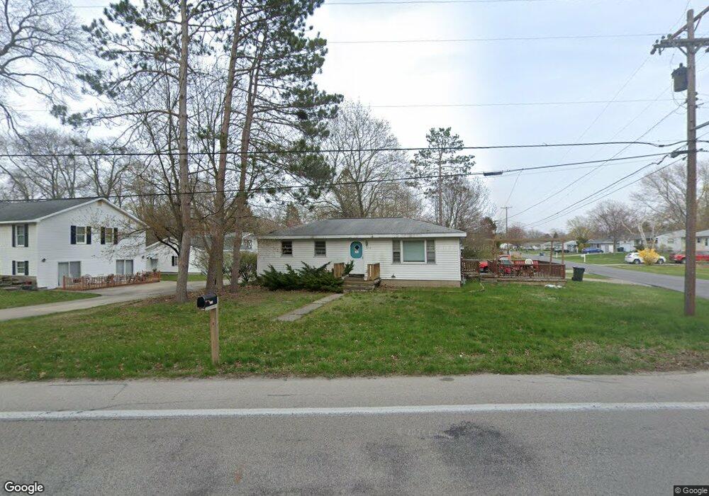
3234 Lincoln St Norton Shores, MI 49441
Estimated Value: $212,000 - $250,000
3
Beds
2
Baths
1,408
Sq Ft
$159/Sq Ft
Est. Value
About This Home
This home is located at 3234 Lincoln St, Norton Shores, MI 49441 and is currently estimated at $224,423, approximately $159 per square foot. 3234 Lincoln St is a home located in Muskegon County with nearby schools including Mona Shores High School, Muskegon Montessori Academy for Environmental Change, and St. Francis De Sales Elementary School.
Ownership History
Date
Name
Owned For
Owner Type
Purchase Details
Closed on
Feb 4, 2008
Sold by
Boucher Maxine
Bought by
Ingleright Rodney M
Current Estimated Value
Purchase Details
Closed on
Oct 31, 2007
Sold by
Boucher Maxine and Boucher Arnold
Bought by
Ingleright Rodney M
Home Financials for this Owner
Home Financials are based on the most recent Mortgage that was taken out on this home.
Original Mortgage
$61,000
Interest Rate
6.47%
Mortgage Type
Purchase Money Mortgage
Create a Home Valuation Report for This Property
The Home Valuation Report is an in-depth analysis detailing your home's value as well as a comparison with similar homes in the area
Home Values in the Area
Average Home Value in this Area
Purchase History
| Date | Buyer | Sale Price | Title Company |
|---|---|---|---|
| Ingleright Rodney M | -- | Woodland Title | |
| Ingleright Rodney M | $61,000 | Woodland Title |
Source: Public Records
Mortgage History
| Date | Status | Borrower | Loan Amount |
|---|---|---|---|
| Previous Owner | Ingleright Rodney M | $61,000 |
Source: Public Records
Tax History Compared to Growth
Tax History
| Year | Tax Paid | Tax Assessment Tax Assessment Total Assessment is a certain percentage of the fair market value that is determined by local assessors to be the total taxable value of land and additions on the property. | Land | Improvement |
|---|---|---|---|---|
| 2025 | $1,745 | $84,400 | $0 | $0 |
| 2024 | $1,368 | $77,900 | $0 | $0 |
| 2023 | $1,307 | $68,700 | $0 | $0 |
| 2022 | $1,593 | $57,900 | $0 | $0 |
| 2021 | $1,548 | $52,700 | $0 | $0 |
| 2020 | $1,530 | $49,200 | $0 | $0 |
| 2019 | $1,502 | $44,300 | $0 | $0 |
| 2018 | $1,467 | $43,200 | $0 | $0 |
| 2017 | $1,433 | $41,900 | $0 | $0 |
| 2016 | $1,110 | $39,200 | $0 | $0 |
| 2015 | -- | $36,600 | $0 | $0 |
| 2014 | $1,332 | $36,500 | $0 | $0 |
| 2013 | -- | $34,500 | $0 | $0 |
Source: Public Records
Map
Nearby Homes
- 2263 Lawnel Ave
- 2280 Arbor Ave
- 2278 Reneer Ave
- 3507 Winnetaska Rd
- 3283 Mccracken St
- 1936 Lawnel Ave
- 2361 Norman Ave
- 2270 Norman Ave
- 2115 Garland Dr
- 2059 Garland Dr
- 2715 Liberty Rd
- 2686 Forest Hills Rd
- 2044 Belmont Dr
- 1744 W Norton Ave
- 1733 Woodside Rd
- 1752 Bonneville Dr
- 1947 Spencer Dr
- 2290 Blissfield Ct
- 2648 Bellevue Rd
- 2165 Letart Ave
- 3222 Lincoln St
- 2304 Lawnel Ave
- 3262 Lincoln St
- 2299 Lawnel Ave
- 3204 Lincoln St
- 2286 Lawnel Ave
- 3272 Lincoln St
- 2287 Lawnel Ave
- 2289 Arbor Ave
- 2293 Arbor Ave
- 2276 Lawnel Ave
- 3192 Lincoln St
- 3286 Lincoln St
- 2275 Lawnel Ave
- 2279 Arbor Ave
- 2264 Lawnel Ave
- 2304 Columbus Ave
- 2321 Arbor Ave
- 2295 Arbor Ave
- 2294 Columbus Ave