Estimated Value: $209,459 - $392,000
--
Bed
--
Bath
1,448
Sq Ft
$202/Sq Ft
Est. Value
About This Home
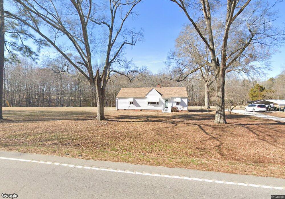
This home is located at 324 Cameron Rd, York, SC 29745 and is currently estimated at $292,365, approximately $201 per square foot. 324 Cameron Rd is a home located in York County with nearby schools including Jefferson Elementary School, York Intermediate School, and York Middle School.
Ownership History
Date
Name
Owned For
Owner Type
Purchase Details
Closed on
Mar 25, 2021
Sold by
Allocca Enterprises Inc
Bought by
Mullis Stanley L and Mullis Anna L
Current Estimated Value
Purchase Details
Closed on
Dec 29, 2020
Sold by
Thickens Wanda M and Mullis Leon Eddy
Bought by
Allocca Enterprises Inc
Purchase Details
Closed on
Dec 14, 2020
Sold by
Thickens Wanda M and Estate Of Betty Falls Mullis
Bought by
Thickens Wanda M and Millis Leon Eddy
Purchase Details
Closed on
Feb 8, 2017
Sold by
Mullis Betty Fails and Estate Of Leon B Mullis
Bought by
Mullis Betty Falls
Create a Home Valuation Report for This Property
The Home Valuation Report is an in-depth analysis detailing your home's value as well as a comparison with similar homes in the area
Home Values in the Area
Average Home Value in this Area
Purchase History
| Date | Buyer | Sale Price | Title Company |
|---|---|---|---|
| Mullis Stanley L | -- | None Available | |
| Allocca Enterprises Inc | $138,000 | None Available | |
| Allocca Enterprises Inc | $138,000 | None Listed On Document | |
| Thickens Wanda M | -- | None Available | |
| Mullis Stanley L | -- | None Available | |
| Mullis Betty Falls | -- | None Available |
Source: Public Records
Tax History Compared to Growth
Tax History
| Year | Tax Paid | Tax Assessment Tax Assessment Total Assessment is a certain percentage of the fair market value that is determined by local assessors to be the total taxable value of land and additions on the property. | Land | Improvement |
|---|---|---|---|---|
| 2024 | $508 | $4,998 | $1,120 | $3,878 |
| 2023 | $519 | $4,998 | $1,120 | $3,878 |
| 2022 | $520 | $5,001 | $1,120 | $3,881 |
| 2021 | -- | $5,001 | $1,120 | $3,881 |
| 2020 | $219 | $3,215 | $0 | $0 |
| 2019 | $154 | $2,801 | $0 | $0 |
| 2018 | $148 | $2,801 | $0 | $0 |
| 2017 | $141 | $2,801 | $0 | $0 |
| 2016 | $139 | $2,801 | $0 | $0 |
| 2014 | $144 | $2,801 | $341 | $2,460 |
| 2013 | $144 | $2,901 | $321 | $2,580 |
Source: Public Records
Map
Nearby Homes
- 249 Brown Neal Rd
- 2209 Cedar Rd
- 2099 Cedar Rd
- 2078 Garvin Rd
- 431 Stacy Ln
- 1975 Bowlin Ln
- 1066 Cameron Rd
- 108 Daves Rd
- Millbrook Plan at McFarland Estates
- Bellwood Plan at McFarland Estates
- Morganton Plan at McFarland Estates
- 459 Brick House Rd
- Hamilton Plan at McFarland Estates
- 473 Brick House Rd
- 462 Brick House Rd Unit 123
- Belair II Plan at McFarland Estates
- Liberty Plan at McFarland Estates
- 8229 Park Place Rd
- 2018 Whiskery Ct
- 1482 Kate Cecil Way
- 350 Cameron Rd
- 374 Cameron Rd
- 288 Cameron Rd
- 356 Cameron Rd
- 281 Cameron Rd
- 262 Cameron Rd
- 228 Cameron Rd
- 310 Bolivar Rd
- 174 Cameron Rd
- 485 Carson Rd
- 175 Cameron Rd
- 175 Cameron Rd
- 160 Cameron Rd
- 500 Carson Rd
- 140 Cameron Rd
- 184 Brown Neal Rd
- 196 Brown Neal Rd
- 210 Brown Neal Rd
- 172 Brown Neal Rd
- 224 Brown Neal Rd