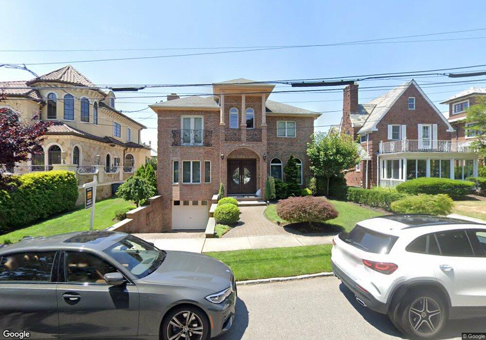
324 Parsons Blvd Whitestone, NY 11357
Whitestone NeighborhoodEstimated Value: $1,840,000 - $1,992,000
3
Beds
4
Baths
2,854
Sq Ft
$676/Sq Ft
Est. Value
About This Home
This home is located at 324 Parsons Blvd, Whitestone, NY 11357 and is currently estimated at $1,928,694, approximately $675 per square foot. 324 Parsons Blvd is a home located in Queens County with nearby schools including P.S. 79 - Francis Lewis, J.H.S. 194 William Carr, and Flushing High School.
Ownership History
Date
Name
Owned For
Owner Type
Purchase Details
Closed on
Jun 28, 2024
Sold by
Laurita Elvira and Mercadante Saverino
Bought by
Bercarich John
Current Estimated Value
Purchase Details
Closed on
Jan 17, 2006
Sold by
Hoskins Carol N and Hoskins Riverwalk
Bought by
Laurita Elvira and Mercadante Saverino
Home Financials for this Owner
Home Financials are based on the most recent Mortgage that was taken out on this home.
Original Mortgage
$350,000
Interest Rate
6.31%
Mortgage Type
Purchase Money Mortgage
Create a Home Valuation Report for This Property
The Home Valuation Report is an in-depth analysis detailing your home's value as well as a comparison with similar homes in the area
Home Values in the Area
Average Home Value in this Area
Purchase History
We collect this data history from publicly available records. To have your information removed, we recommend requesting removal directly through your county’s website.
| Date | Buyer | Sale Price | Title Company |
|---|---|---|---|
| Bercarich John | $1,950,000 | -- | |
| Bercarich John | $1,950,000 | -- | |
| Laurita Elvira | $900,000 | -- | |
| Laurita Elvira | $900,000 | -- |
Source: Public Records
Mortgage History
We collect this data history from publicly available records. To have your information removed, we recommend requesting removal directly through your county’s website.
| Date | Status | Borrower | Loan Amount |
|---|---|---|---|
| Previous Owner | Laurita Elvira | $350,000 |
Source: Public Records
Tax History
| Year | Tax Paid | Tax Assessment Tax Assessment Total Assessment is a certain percentage of the fair market value that is determined by local assessors to be the total taxable value of land and additions on the property. | Land | Improvement |
|---|---|---|---|---|
| 2026 | $17,821 | $94,051 | $11,264 | $82,787 |
| 2025 | $16,813 | $88,728 | $11,158 | $77,570 |
| 2024 | $16,813 | $83,707 | $9,927 | $73,780 |
| 2023 | $15,861 | $78,970 | $10,334 | $68,636 |
| 2022 | $15,765 | $87,480 | $13,740 | $73,740 |
| 2021 | $16,494 | $93,540 | $13,740 | $79,800 |
| 2020 | $15,651 | $80,460 | $13,740 | $66,720 |
| 2019 | $14,592 | $86,100 | $13,740 | $72,360 |
| 2018 | $13,117 | $65,808 | $8,981 | $56,827 |
| 2017 | $13,115 | $65,808 | $7,969 | $57,839 |
| 2016 | $12,747 | $65,808 | $7,969 | $57,839 |
| 2015 | $7,619 | $61,617 | $12,977 | $48,640 |
| 2014 | $7,619 | $58,130 | $14,691 | $43,439 |
Source: Public Records
Map
Nearby Homes
- 330 Parsons Blvd
- 320 Parsons Blvd
- 3-20 Parsons Blvd
- 3-34 Parsons Blvd
- 334 Parsons Blvd
- 316 Parsons Blvd
- 340 Parsons Blvd
- 3-15 Malba Dr
- 340 Parsons Blvd
- 333 Parsons Blvd
- 98 Malba Dr
- 106 Parsons Blvd
- 304 Parsons Blvd
- 413 Parsons Blvd
- 315 Parsons Blvd
- 417 Parsons Blvd
- 1 Summit Place
- 1 Summit Place Unit Building
- 417 Parsons Blvd
- 3 Summit Place
Your Personal Tour Guide
Ask me questions while you tour the home.