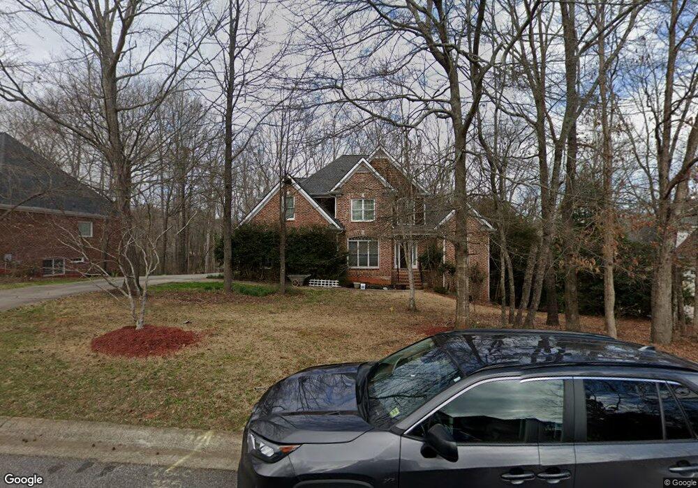
325 Ashbrook Ln Athens, GA 30605
Estimated Value: $654,000 - $773,000
4
Beds
4
Baths
4,393
Sq Ft
$157/Sq Ft
Est. Value
About This Home
This home is located at 325 Ashbrook Ln, Athens, GA 30605 and is currently estimated at $688,345, approximately $156 per square foot. 325 Ashbrook Ln is a home located in Clarke County with nearby schools including Barnett Shoals Elementary School, Hilsman Middle School, and Cedar Shoals High School.
Ownership History
Date
Name
Owned For
Owner Type
Purchase Details
Closed on
Jun 3, 2004
Sold by
Home South Construction Compan
Bought by
Mceachern Michael J and Estrella Mcea
Current Estimated Value
Purchase Details
Closed on
Nov 4, 2003
Sold by
Ashton Place Partnership
Bought by
Home South Construction Company Inc
Create a Home Valuation Report for This Property
The Home Valuation Report is an in-depth analysis detailing your home's value as well as a comparison with similar homes in the area
Home Values in the Area
Average Home Value in this Area
Purchase History
| Date | Buyer | Sale Price | Title Company |
|---|---|---|---|
| Mceachern Michael J | $368,500 | -- | |
| Home South Construction Company Inc | $45,000 | -- |
Source: Public Records
Tax History Compared to Growth
Tax History
| Year | Tax Paid | Tax Assessment Tax Assessment Total Assessment is a certain percentage of the fair market value that is determined by local assessors to be the total taxable value of land and additions on the property. | Land | Improvement |
|---|---|---|---|---|
| 2025 | $6,570 | $259,184 | $23,000 | $236,184 |
| 2024 | $6,570 | $243,296 | $20,700 | $222,596 |
| 2023 | $6,614 | $217,237 | $20,700 | $196,537 |
| 2022 | $5,746 | $190,112 | $20,700 | $169,412 |
| 2021 | $5,368 | $169,295 | $20,700 | $148,595 |
| 2020 | $5,013 | $158,750 | $20,700 | $138,050 |
| 2019 | $4,745 | $149,765 | $20,700 | $129,065 |
| 2018 | $4,655 | $147,101 | $20,700 | $126,401 |
| 2017 | $5,042 | $158,527 | $20,700 | $137,827 |
| 2016 | $5,094 | $160,058 | $20,700 | $139,358 |
| 2015 | $5,154 | $161,589 | $20,700 | $140,889 |
| 2014 | $4,858 | $152,649 | $20,700 | $131,949 |
Source: Public Records
Map
Nearby Homes
- 430 Forest Rd
- 211 Stonecrest Ct
- 352 Greencrest Dr
- 354 Greencrest Dr
- 170 Brookwood Dr
- 0 Barnett Shoals Rd Unit Lot 2
- 0 Barnett Shoals Rd Unit Lot 1
- 400 Greencrest Dr
- 157 Wakefield Trace
- 135 Wakefield Dr
- 148 Warren Way
- 150 Greenwood Ln
- 200 Scandia Cir Unit 5
- 1283 Cedar Shoals Dr
- 140 Whitehall Rd
- 171 Birch Valley Dr
- 321 Ashbrook Ln
- 329 Ashbrook Ln
- 0 Ashbrook Ln Unit CM402727
- 317 Ashbrook Ln
- 333 Ashbrook Ln
- 324 Ashbrook Ln
- Lot 20 Ashbrook Ln
- Lot 10D Ashbrook Ln
- Lot 27 Ashbrook Ln
- Lot 26 Ashbrook Ln
- Lot 31 Ashbrook Ln
- Lot 10 Ashbrook Ln
- Lot 9 Ashbrook Ln
- Lot 11 Ashbrook Ln
- Lot 23 Ashbrook Ln
- Lot 30 Ashbrook Ln
- Lot 21 Ashbrook Ln
- Lot 12 Ashbrook Ln
- Lot 33 Ashbrook Ln
- Lot 19 Ashbrook Ln