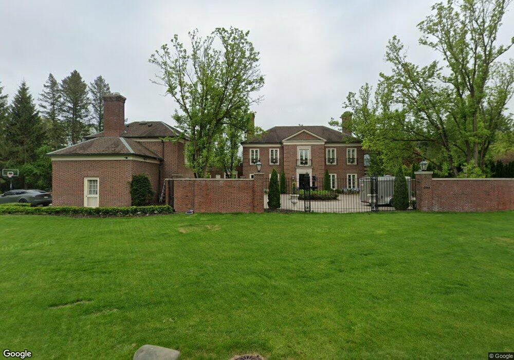
325 Dunston Rd Unit Bldg-Unit Bloomfield Hills, MI 48304
Estimated Value: $3,069,376 - $3,899,000
3
Beds
6
Baths
6,661
Sq Ft
$549/Sq Ft
Est. Value
About This Home
This home is located at 325 Dunston Rd Unit Bldg-Unit, Bloomfield Hills, MI 48304 and is currently estimated at $3,659,844, approximately $549 per square foot. 325 Dunston Rd Unit Bldg-Unit is a home located in Oakland County with nearby schools including Quarton Elementary, Derby Middle School, and Ernest W. Seaholm High School.
Ownership History
Date
Name
Owned For
Owner Type
Purchase Details
Closed on
Jan 29, 2021
Sold by
Bassett Anna and Bassett Joseph S
Bought by
Wahab Baseem and Alcodray Amal
Current Estimated Value
Create a Home Valuation Report for This Property
The Home Valuation Report is an in-depth analysis detailing your home's value as well as a comparison with similar homes in the area
Home Values in the Area
Average Home Value in this Area
Purchase History
| Date | Buyer | Sale Price | Title Company |
|---|---|---|---|
| Wahab Baseem | $2,300,000 | Interstate Title Inc |
Source: Public Records
Tax History Compared to Growth
Tax History
| Year | Tax Paid | Tax Assessment Tax Assessment Total Assessment is a certain percentage of the fair market value that is determined by local assessors to be the total taxable value of land and additions on the property. | Land | Improvement |
|---|---|---|---|---|
| 2024 | $39,887 | $1,293,520 | $0 | $0 |
| 2023 | $38,179 | $1,196,300 | $0 | $0 |
| 2022 | $42,836 | $1,183,760 | $0 | $0 |
| 2021 | $32,135 | $1,500,920 | $0 | $0 |
| 2020 | $28,624 | $1,452,510 | $0 | $0 |
| 2019 | $31,823 | $1,442,550 | $0 | $0 |
| 2018 | $31,504 | $1,350,210 | $0 | $0 |
| 2017 | $31,404 | $1,252,260 | $0 | $0 |
| 2016 | $31,429 | $1,153,790 | $0 | $0 |
| 2015 | -- | $1,068,060 | $0 | $0 |
| 2014 | -- | $936,760 | $0 | $0 |
| 2011 | -- | $820,270 | $0 | $0 |
Source: Public Records
Map
Nearby Homes
- 1260 Lyonhurst St
- 591 Rudgate Rd
- 1120 Lyonhurst St
- 596 Rudgate Rd
- 956 Westwood Dr
- 1537 Ashford Ln
- 170 Kirkwood Ct
- 1183 Puritan Ave
- 692 Bennington Dr
- 1551 Lakeside Dr
- 1295 Lakeside Dr
- 4890 Charing Cross Rd
- 1287 Charrington Rd
- 586 Fairfax St
- 362 Keswick Rd
- 931 Vaughan Rd
- 3673 York Ct
- 1115 N Old Woodward Ave Unit 52
- 1115 N Old Woodward Ave Unit 61
- 1115 N Old Woodward #76 Ave
- 325 Dunston Rd
- 300 Woodridge Rd
- 345 Dunston Rd
- 300 Cranbrook Rd Unit Bldg-Unit
- 300 Cranbrook Rd
- 300 Cranbrook Rd
- 330 Woodridge Rd
- 320 Dunston Rd
- 250 Cranbrook Rd
- 365 Dunston Rd
- 355 Cranbrook Rd
- 355 Cranbrook Rd
- 360 Woodridge Rd
- 345 Woodridge Rd
- 411 Goodhue Rd
- 220 Cranbrook Rd
- 381 Cranbrook Rd
- 394 Cranbrook Rd
- 310 Cranbrook Rd
- 310 Cranbrook Rd