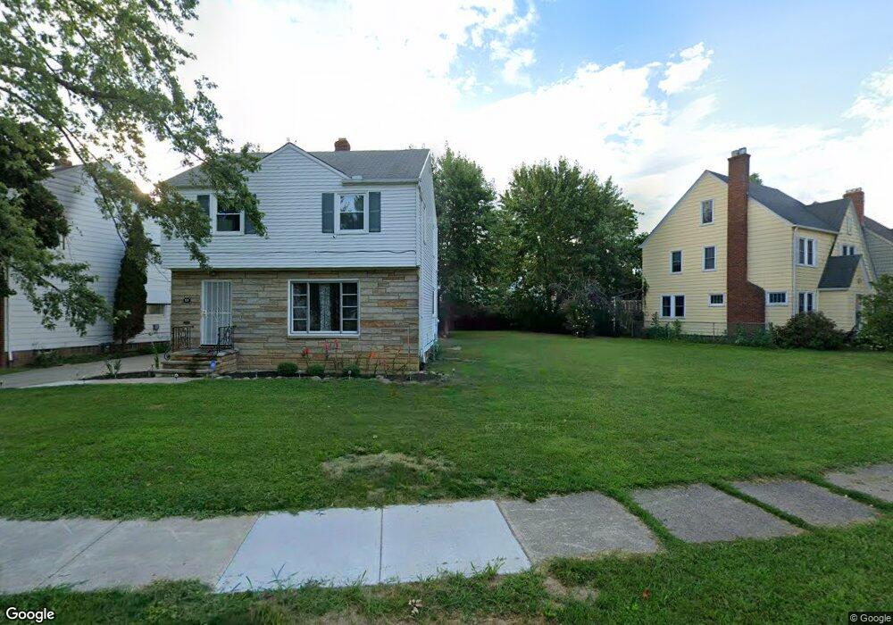
325 E 215th St Euclid, OH 44123
3
Beds
1
Bath
1,196
Sq Ft
5,663
Sq Ft Lot
About This Home
This home is located at 325 E 215th St, Euclid, OH 44123. 325 E 215th St is a home located in Cuyahoga County with nearby schools including Arbor Elementary School, Euclid Middle School, and Euclid High School.
Ownership History
Date
Name
Owned For
Owner Type
Purchase Details
Closed on
Mar 11, 2024
Sold by
Euclid Land Reutilization Prog
Bought by
Walker Tanesha
Purchase Details
Closed on
Aug 11, 2017
Sold by
Our Family
Bought by
Program Euclid Land Reutilization
Purchase Details
Closed on
Dec 12, 2012
Sold by
Capitalsource Bank
Bought by
Aeon Financial Llc
Purchase Details
Closed on
May 14, 2012
Sold by
Gonakis Spiros
Bought by
Capitalsource Bank and Aeon Financial Llc
Purchase Details
Closed on
Sep 15, 2005
Sold by
Estate Of Donald E Raybuck Sr
Bought by
Raybuck Jacquelyn H
Purchase Details
Closed on
Sep 24, 2003
Sold by
Estate Of Grace M Raybuck
Bought by
Raybuck Donald
Purchase Details
Closed on
Jan 1, 1975
Bought by
Raybuck Donald E and Raybuck Grace M
Create a Home Valuation Report for This Property
The Home Valuation Report is an in-depth analysis detailing your home's value as well as a comparison with similar homes in the area
Home Values in the Area
Average Home Value in this Area
Purchase History
| Date | Buyer | Sale Price | Title Company |
|---|---|---|---|
| Walker Tanesha | $1,000 | None Listed On Document | |
| Program Euclid Land Reutilization | -- | None Available | |
| Aeon Financial Llc | -- | Attorney | |
| Capitalsource Bank | $21,214 | None Available | |
| Raybuck Jacquelyn H | -- | -- | |
| Raybuck Donald | -- | -- | |
| Raybuck Donald E | -- | -- |
Source: Public Records
Tax History
| Year | Tax Paid | Tax Assessment Tax Assessment Total Assessment is a certain percentage of the fair market value that is determined by local assessors to be the total taxable value of land and additions on the property. | Land | Improvement |
|---|---|---|---|---|
| 2025 | $44 | $700 | $700 | -- |
| 2024 | -- | $700 | $700 | -- |
| 2022 | $0 | $5,530 | $5,530 | $0 |
| 2021 | $0 | $5,530 | $5,530 | $0 |
Source: Public Records
Map
Nearby Homes
- 324 E 215th St
- 285 E 216th St
- 21051 S Lake Shore Blvd
- 21971 Crystal Ave
- 21670 Crystal Ave
- 273 E 208th St
- 422 Clearview Dr Unit J10
- 421 Kenwood Dr Unit G
- 336 E 222nd St
- 226 E 216th St
- 21000 Crystal Ave
- 442 Clearview Dr Unit U9
- 450 Kenwood Dr Unit D-12
- 20931 Priday Ave
- 461 Kenwood Dr Unit T3
- 22751 Fox Ave
- 21481 Ball Ave
- 20900 Priday Ave
- 144 E 208th St
- 521 Kenwood Dr Unit B-5
- 323 E 215th St
- 329 E 215th St
- 321 E 215th St
- 335 E 215th St
- 21531 Roberts Ave
- 21590 Kennison Ave
- 21561 Roberts Ave
- 21600 Kennison Ave
- 322 E 215th St
- 316 E 215th St
- 330 E 215th St
- 21630 Kennison Ave
- 312 E 215th St
- 345 E 215th St
- 338 E 215th St
- 21611 Roberts Ave
- 21660 Kennison Ave
- 344 E 215th St
- 316 E 216th St
- 351 E 215th St
Your Personal Tour Guide
Ask me questions while you tour the home.