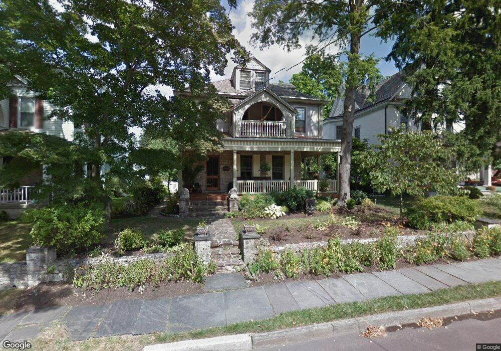
325 Euclid Ave Ambler, PA 19002
Estimated Value: $626,935 - $724,000
6
Beds
3
Baths
2,467
Sq Ft
$274/Sq Ft
Est. Value
About This Home
This home is located at 325 Euclid Ave, Ambler, PA 19002 and is currently estimated at $676,734, approximately $274 per square foot. 325 Euclid Ave is a home located in Montgomery County with nearby schools including Lower Gwynedd El School, Wissahickon Middle School, and Wissahickon Senior High School.
Ownership History
Date
Name
Owned For
Owner Type
Purchase Details
Closed on
Jul 12, 2006
Sold by
Gazdick Lisa
Bought by
Regan Kenneth P and Regan Linda L
Current Estimated Value
Home Financials for this Owner
Home Financials are based on the most recent Mortgage that was taken out on this home.
Original Mortgage
$60,000
Outstanding Balance
$35,660
Interest Rate
6.67%
Estimated Equity
$641,074
Purchase Details
Closed on
Jan 18, 1994
Sold by
Brooks Verna D
Bought by
Gazdick Lisa P
Create a Home Valuation Report for This Property
The Home Valuation Report is an in-depth analysis detailing your home's value as well as a comparison with similar homes in the area
Home Values in the Area
Average Home Value in this Area
Purchase History
| Date | Buyer | Sale Price | Title Company |
|---|---|---|---|
| Regan Kenneth P | $400,000 | None Available | |
| Gazdick Lisa P | $170,000 | -- |
Source: Public Records
Mortgage History
| Date | Status | Borrower | Loan Amount |
|---|---|---|---|
| Open | Regan Kenneth P | $60,000 | |
| Open | Regan Kenneth P | $320,000 |
Source: Public Records
Tax History Compared to Growth
Tax History
| Year | Tax Paid | Tax Assessment Tax Assessment Total Assessment is a certain percentage of the fair market value that is determined by local assessors to be the total taxable value of land and additions on the property. | Land | Improvement |
|---|---|---|---|---|
| 2025 | $6,156 | $165,530 | -- | -- |
| 2024 | $6,156 | $165,530 | -- | -- |
| 2023 | $5,783 | $165,530 | $0 | $0 |
| 2022 | $5,610 | $165,530 | $0 | $0 |
| 2021 | $5,463 | $165,530 | $0 | $0 |
| 2020 | $5,264 | $165,530 | $0 | $0 |
| 2019 | $5,169 | $165,530 | $0 | $0 |
| 2018 | $1,856 | $165,530 | $0 | $0 |
| 2017 | $4,966 | $165,530 | $0 | $0 |
| 2016 | $4,901 | $165,530 | $0 | $0 |
| 2015 | $4,612 | $165,530 | $0 | $0 |
| 2014 | $4,612 | $161,530 | $29,720 | $131,810 |
Source: Public Records
Map
Nearby Homes
- 609 Ardross Ave
- 25 N Ridge Ave Unit A
- 25 N Ridge Ave Unit B
- 401 Highland Ave
- 330 Highland Ave
- 221 Belmont Ave
- 900 Bellaire Ave
- 19 Orange Ave
- 232 Southern Ave
- 0 Renfrew Ave
- 620 Meadowbrook Ave
- 49 Cavendish Dr
- 157 Edgewood Dr
- 108 Brookwood Dr
- 88 Hampstead Dr
- 90 Hampstead Dr Unit 90
- 119 Hampstead Dr Unit 119
- 100 Ambler Rd
- 210 S Chestnut St
- 459 Edgewood Dr
- 321 Euclid Ave
- 329 Euclid Ave Unit 8
- 317 Euclid Ave
- 333 Euclid Ave
- 111 North St
- 313 Euclid Ave
- 332 Lindenwold Ave
- 338 Lindenwold Ave
- 326 Lindenwold Ave
- 330 Euclid Ave
- 320 Lindenwold Ave
- 309 Euclid Ave
- 337 Euclid Ave
- 337 Euclid Ave Unit 3
- 337 Euclid Ave Unit 1-2
- 320 Euclid Ave
- 342 Lindenwold Ave
- 314 Lindenwold Ave
- 332 Euclid Ave
- 314 Euclid Ave