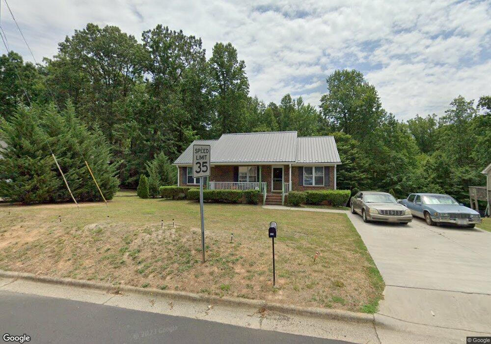
325 Hubbard St Reidsville, NC 27320
Estimated Value: $168,000 - $202,000
3
Beds
2
Baths
1,164
Sq Ft
$163/Sq Ft
Est. Value
About This Home
This home is located at 325 Hubbard St, Reidsville, NC 27320 and is currently estimated at $189,231, approximately $162 per square foot. 325 Hubbard St is a home located in Rockingham County with nearby schools including Reidsville High School, Moss Street Elementary, and Reidsville Middle School.
Ownership History
Date
Name
Owned For
Owner Type
Purchase Details
Closed on
Oct 3, 2024
Sold by
Brooks Samantha Neal and Neal Samantha
Bought by
Neal Kip Tyrone and Brooks Samantha Neal
Current Estimated Value
Purchase Details
Closed on
Dec 10, 2007
Sold by
Wells Fargo Bank Na
Bought by
Neal Melvin Elwood
Purchase Details
Closed on
Dec 28, 2006
Sold by
Stewart Robert C
Bought by
Wells Fargo Bank Na
Create a Home Valuation Report for This Property
The Home Valuation Report is an in-depth analysis detailing your home's value as well as a comparison with similar homes in the area
Home Values in the Area
Average Home Value in this Area
Purchase History
| Date | Buyer | Sale Price | Title Company |
|---|---|---|---|
| Neal Kip Tyrone | -- | None Listed On Document | |
| Neal Melvin Elwood | $80,000 | None Available | |
| Wells Fargo Bank Na | $17,000 | None Available |
Source: Public Records
Tax History Compared to Growth
Tax History
| Year | Tax Paid | Tax Assessment Tax Assessment Total Assessment is a certain percentage of the fair market value that is determined by local assessors to be the total taxable value of land and additions on the property. | Land | Improvement |
|---|---|---|---|---|
| 2025 | $2,225 | $179,395 | $5,350 | $174,045 |
| 2024 | $2,225 | $179,395 | $5,350 | $174,045 |
| 2023 | $2,225 | $107,347 | $4,864 | $102,483 |
| 2022 | $1,539 | $107,347 | $4,864 | $102,483 |
| 2021 | $1,539 | $107,347 | $4,864 | $102,483 |
| 2020 | $775 | $107,347 | $4,864 | $102,483 |
| 2019 | $775 | $107,347 | $4,864 | $102,483 |
| 2018 | $736 | $102,463 | $8,776 | $93,687 |
| 2017 | $736 | $102,463 | $8,776 | $93,687 |
| 2015 | $440 | $102,463 | $8,776 | $93,687 |
| 2014 | $736 | $102,463 | $8,776 | $93,687 |
Source: Public Records
Map
Nearby Homes
- 315 Hubbard St
- 00 Robinson Cir
- 802 Lawsonville Ave
- 403 Pennsylvania Ave
- 101 S Branch St
- 335 S Branch St
- 312 Church St
- 511 Barnes St
- 515 Barnes St
- 115 N Harris St
- 612 Thomas St
- 502 Thomas St
- 607 Lancaster Dr
- 137 Ridge St
- 816 Barnes St
- 00 E Morehead St
- 105 Edna St
- 802 Montgomery St
- 117 Ridge St
- 000 Hwy 158 Hwy
- 327 Hubbard St
- 323 Hubbard St
- 326 Hubbard St
- 329 Hubbard St
- 328 Hubbard St
- 324 Hubbard St
- 330 Hubbard St
- 319 Hubbard St
- 322 Hubbard St
- 332 Hubbard St
- 854 Robinson Cir
- 846 Robinson Cir
- 314 Hubbard St
- 313 Hubbard St
- 404 Hubbard St
- 312 Hubbard St
- 311 Hubbard St
- 851 Robinson Cir
- 310 Hubbard St
- 849 Robinson Cir