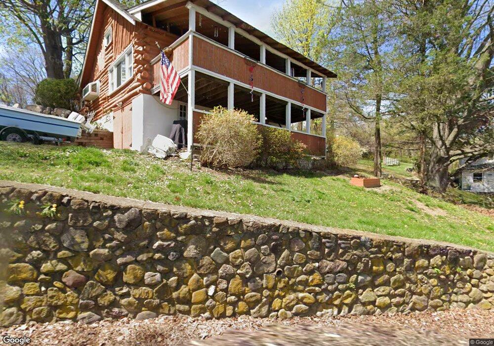
325 Maple Rd West Milford, NJ 07480
Estimated Value: $372,000 - $435,693
3
Beds
2
Baths
1,534
Sq Ft
$269/Sq Ft
Est. Value
About This Home
This home is located at 325 Maple Rd, West Milford, NJ 07480 and is currently estimated at $411,923, approximately $268 per square foot. 325 Maple Rd is a home located in Passaic County with nearby schools including Macopin Middle School and West Milford High School.
Ownership History
Date
Name
Owned For
Owner Type
Purchase Details
Closed on
Apr 15, 2008
Sold by
Nieves Anne and Nieves Ben
Bought by
Schmidt Matthew J and Schmidt Erika L
Current Estimated Value
Home Financials for this Owner
Home Financials are based on the most recent Mortgage that was taken out on this home.
Original Mortgage
$279,891
Outstanding Balance
$178,498
Interest Rate
6.1%
Mortgage Type
VA
Estimated Equity
$233,425
Purchase Details
Closed on
Oct 7, 2002
Sold by
Vrsalovic Michael
Bought by
Readie Anne
Home Financials for this Owner
Home Financials are based on the most recent Mortgage that was taken out on this home.
Original Mortgage
$186,000
Interest Rate
6.2%
Purchase Details
Closed on
Nov 4, 1999
Sold by
Liberty Lending Bank Fsb
Bought by
Liberty Svgs Bank Fsb
Home Financials for this Owner
Home Financials are based on the most recent Mortgage that was taken out on this home.
Original Mortgage
$98,306
Interest Rate
7.77%
Mortgage Type
FHA
Purchase Details
Closed on
Oct 26, 1999
Sold by
Liberty Svgs Bank Fsb
Bought by
Vrsalovic Michael M
Home Financials for this Owner
Home Financials are based on the most recent Mortgage that was taken out on this home.
Original Mortgage
$98,306
Interest Rate
7.77%
Mortgage Type
FHA
Purchase Details
Closed on
Apr 26, 1999
Sold by
Holm Martin David and Holm Janet Mary
Bought by
Liberty Lending Bank Fsb
Create a Home Valuation Report for This Property
The Home Valuation Report is an in-depth analysis detailing your home's value as well as a comparison with similar homes in the area
Home Values in the Area
Average Home Value in this Area
Purchase History
| Date | Buyer | Sale Price | Title Company |
|---|---|---|---|
| Schmidt Matthew J | $274,000 | -- | |
| Readie Anne | $236,000 | -- | |
| Liberty Svgs Bank Fsb | -- | -- | |
| Vrsalovic Michael M | $91,000 | Chicago Title Insurance Co | |
| Liberty Lending Bank Fsb | -- | -- |
Source: Public Records
Mortgage History
| Date | Status | Borrower | Loan Amount |
|---|---|---|---|
| Open | Schmidt Matthew J | $279,891 | |
| Previous Owner | Readie Anne | $186,000 | |
| Previous Owner | Vrsalovic Michael M | $98,306 |
Source: Public Records
Tax History Compared to Growth
Tax History
| Year | Tax Paid | Tax Assessment Tax Assessment Total Assessment is a certain percentage of the fair market value that is determined by local assessors to be the total taxable value of land and additions on the property. | Land | Improvement |
|---|---|---|---|---|
| 2025 | $7,544 | $186,100 | $67,800 | $118,300 |
| 2024 | $7,334 | $186,100 | $67,800 | $118,300 |
| 2022 | $7,198 | $186,100 | $67,800 | $118,300 |
| 2021 | $7,044 | $186,100 | $67,800 | $118,300 |
| 2020 | $6,969 | $186,100 | $67,800 | $118,300 |
| 2019 | $6,876 | $186,100 | $67,800 | $118,300 |
| 2018 | $6,860 | $186,100 | $67,800 | $118,300 |
| 2017 | $6,891 | $186,100 | $67,800 | $118,300 |
| 2016 | $6,652 | $186,100 | $67,800 | $118,300 |
| 2015 | $6,572 | $186,100 | $67,800 | $118,300 |
| 2014 | $6,407 | $186,100 | $67,800 | $118,300 |
Source: Public Records
Map
Nearby Homes
- 66 Lindys Dr
- 16 Pond View Dr
- 54 Broadway
- 3 Broadway
- 0 Post Brook Rd Unit 25008921
- 0 Post Brook Rd Unit 3952366
- 54 Nosenzo Pond Rd
- 449 Otterhole Rd
- 37 Hancock Dr
- 0 Laurel Hollow
- 5 Bisset Dr
- 43 Bisset Dr
- 347 Otterhole Rd
- 174 Kitchell Lake Dr
- 24 Eagles Nest Terrace
- 11 Eagles Nest Terrace
- 33 Eagles Nest Terrace
- 2 Heritage Dr
- 34 Gould Rd
- 60 Eagles Nest Terrace