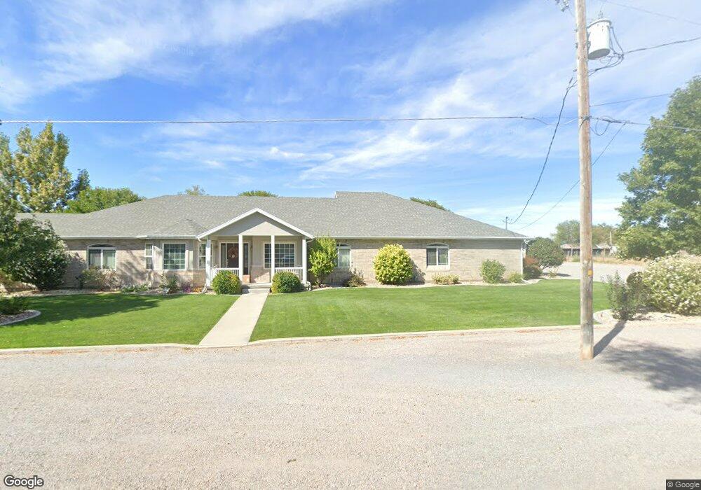
325 N 100 W Hinckley, UT 84635
Estimated Value: $158,000 - $600,643
--
Bed
--
Bath
--
Sq Ft
1.15
Acres
About This Home
This home is located at 325 N 100 W, Hinckley, UT 84635 and is currently estimated at $348,548. 325 N 100 W is a home.
Ownership History
Date
Name
Owned For
Owner Type
Purchase Details
Closed on
Jun 21, 2006
Sold by
Palmer Christpher M
Bought by
Palmer Christpher M and Palmer Christi M
Current Estimated Value
Home Financials for this Owner
Home Financials are based on the most recent Mortgage that was taken out on this home.
Original Mortgage
$285,000
Outstanding Balance
$173,207
Interest Rate
6.57%
Mortgage Type
New Conventional
Estimated Equity
$175,341
Create a Home Valuation Report for This Property
The Home Valuation Report is an in-depth analysis detailing your home's value as well as a comparison with similar homes in the area
Home Values in the Area
Average Home Value in this Area
Purchase History
| Date | Buyer | Sale Price | Title Company |
|---|---|---|---|
| Palmer Christpher M | -- | -- |
Source: Public Records
Mortgage History
| Date | Status | Borrower | Loan Amount |
|---|---|---|---|
| Open | Palmer Christpher M | $285,000 |
Source: Public Records
Tax History Compared to Growth
Tax History
| Year | Tax Paid | Tax Assessment Tax Assessment Total Assessment is a certain percentage of the fair market value that is determined by local assessors to be the total taxable value of land and additions on the property. | Land | Improvement |
|---|---|---|---|---|
| 2025 | $3,308 | $395,088 | $20,584 | $374,504 |
| 2024 | $3,308 | $429,247 | $8,143 | $421,104 |
| 2023 | $4,396 | $429,247 | $8,143 | $421,104 |
| 2022 | $2,870 | $243,200 | $7,434 | $235,766 |
| 2021 | $2,367 | $191,223 | $6,275 | $184,948 |
| 2020 | $1,802 | $145,792 | $6,000 | $139,792 |
| 2019 | $1,783 | $145,485 | $6,000 | $139,485 |
| 2018 | $1,742 | $145,792 | $6,000 | $139,792 |
| 2017 | $1,780 | $142,913 | $6,000 | $136,913 |
| 2016 | $1,704 | $142,913 | $6,000 | $136,913 |
| 2015 | $1,641 | $137,254 | $6,000 | $131,254 |
| 2014 | -- | $137,254 | $6,000 | $131,254 |
| 2013 | -- | $133,431 | $6,000 | $127,431 |
Source: Public Records
Map
Nearby Homes
- 168 N 100 Rd W
- 289 W Center St S
- 6500 W 2000 S
- 1040 W Center St
- 700 Acres
- 1500 S 10000 W
- 6000 N 10000 W
- 700 Acres Hwy 6 & Main St (Hwy 50)
- 2000 E 10500 N
- 6200 S 3000 W
- 3480 S 4000 W
- 3770 S 4000 Rd W
- 0 Tbd 3000 Rd S Unit LotWP001
- 6177 S 3000 Rd W
- 3885 W 4500 S
- 17000 W 2500 Rd S
- 16700 W 2500 South Rd
- 16800 W 2500 South Rd
- 470 S 2750 W Unit 6
- 460 S 2750 W Unit 7