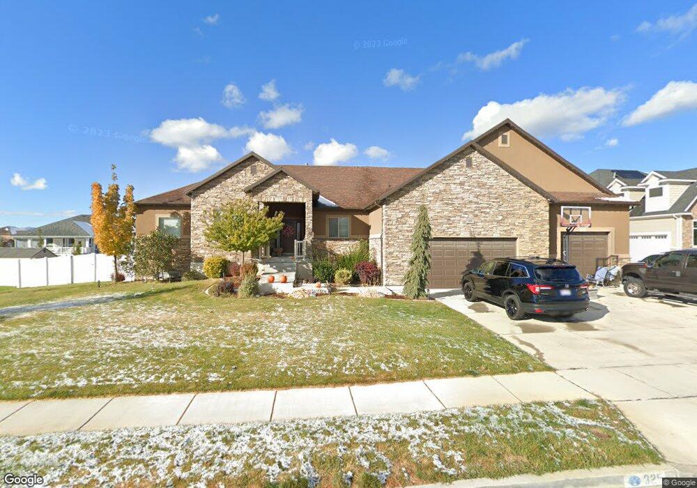
325 N 3425 W Clearfield, UT 84015
Estimated Value: $347,000 - $406,000
3
Beds
1
Bath
1,113
Sq Ft
$349/Sq Ft
Est. Value
About This Home
This home is located at 325 N 3425 W, Clearfield, UT 84015 and is currently estimated at $388,875, approximately $349 per square foot. 325 N 3425 W is a home located in Davis County with nearby schools including West Point School, West Point Junior High School, and Syracuse High School.
Ownership History
Date
Name
Owned For
Owner Type
Purchase Details
Closed on
Aug 25, 2025
Sold by
Eardley Jennica Marie and Eardley Cory
Bought by
325 N 3425 W A Series Of Simple Sold Holdings
Current Estimated Value
Home Financials for this Owner
Home Financials are based on the most recent Mortgage that was taken out on this home.
Original Mortgage
$226,000
Outstanding Balance
$226,000
Interest Rate
6.74%
Mortgage Type
New Conventional
Estimated Equity
$162,875
Purchase Details
Closed on
Aug 15, 2025
Sold by
Simple Sold Homes Llc
Bought by
Eardley Jennica Marie and Eardley Cory
Home Financials for this Owner
Home Financials are based on the most recent Mortgage that was taken out on this home.
Original Mortgage
$226,000
Outstanding Balance
$226,000
Interest Rate
6.74%
Mortgage Type
New Conventional
Estimated Equity
$162,875
Purchase Details
Closed on
Nov 24, 2024
Sold by
Peterson Pattie Lynn
Bought by
Simple Sold Homes Llc
Home Financials for this Owner
Home Financials are based on the most recent Mortgage that was taken out on this home.
Original Mortgage
$245,856
Interest Rate
6.44%
Mortgage Type
Seller Take Back
Purchase Details
Closed on
Feb 9, 2021
Sold by
Peterson Eric
Bought by
Peterson Eric and Peterson Pattie Lynn
Home Financials for this Owner
Home Financials are based on the most recent Mortgage that was taken out on this home.
Original Mortgage
$242,400
Interest Rate
2.6%
Mortgage Type
VA
Purchase Details
Closed on
Nov 26, 2014
Sold by
Peterson Erie Larin
Bought by
Peterson Erie Larin
Purchase Details
Closed on
Jun 4, 2013
Sold by
Young Sherrie A
Bought by
Young Sherrie A and Peterson Eric Larin
Purchase Details
Closed on
Jun 17, 1999
Sold by
Blackham Carri and Blackham Michael A
Bought by
Young Sherrie A
Home Financials for this Owner
Home Financials are based on the most recent Mortgage that was taken out on this home.
Original Mortgage
$92,897
Interest Rate
7.01%
Mortgage Type
FHA
Purchase Details
Closed on
Apr 5, 1999
Sold by
Everett David K and Everett Vickie
Bought by
Blackham Michael and Blackham Carri A
Purchase Details
Closed on
Dec 3, 1998
Sold by
Everett David K and Everett Vickie
Bought by
Hsd Llc
Create a Home Valuation Report for This Property
The Home Valuation Report is an in-depth analysis detailing your home's value as well as a comparison with similar homes in the area
Home Values in the Area
Average Home Value in this Area
Purchase History
| Date | Buyer | Sale Price | Title Company |
|---|---|---|---|
| 325 N 3425 W A Series Of Simple Sold Holdings | -- | Title Guarantee | |
| Eardley Jennica Marie | -- | Title Guarantee | |
| Eardley Jennica Marie | -- | Title Guarantee | |
| Simple Sold Homes Llc | -- | Real Advantage Title | |
| Peterson Eric | -- | Accommodation | |
| Peterson Eric | -- | First American Title | |
| Peterson Erie Larin | -- | Magellan Title | |
| Young Sherrie A | -- | Founders Title Co L | |
| Young Sherrie A | -- | First American Title Co | |
| Blackham Michael | $65,649 | -- | |
| Hsd Llc | $65,600 | -- |
Source: Public Records
Mortgage History
| Date | Status | Borrower | Loan Amount |
|---|---|---|---|
| Open | 325 N 3425 W A Series Of Simple Sold Holdings | $226,000 | |
| Previous Owner | Simple Sold Homes Llc | $245,856 | |
| Previous Owner | Peterson Eric | $242,400 | |
| Previous Owner | Young Sherrie A | $92,897 |
Source: Public Records
Tax History Compared to Growth
Tax History
| Year | Tax Paid | Tax Assessment Tax Assessment Total Assessment is a certain percentage of the fair market value that is determined by local assessors to be the total taxable value of land and additions on the property. | Land | Improvement |
|---|---|---|---|---|
| 2025 | $2,031 | $190,300 | $119,396 | $70,904 |
| 2024 | $1,911 | $179,850 | $107,457 | $72,393 |
| 2023 | $1,767 | $306,000 | $136,011 | $169,989 |
| 2022 | $1,880 | $178,200 | $71,331 | $106,869 |
| 2021 | $1,714 | $243,000 | $109,206 | $133,794 |
| 2020 | $1,494 | $209,000 | $92,149 | $116,851 |
| 2019 | $1,442 | $199,000 | $89,281 | $109,719 |
| 2018 | $1,316 | $179,000 | $88,394 | $90,606 |
| 2016 | $1,134 | $81,125 | $34,241 | $46,884 |
| 2015 | $1,051 | $71,225 | $34,241 | $36,984 |
| 2014 | $1,076 | $74,001 | $34,241 | $39,760 |
| 2013 | -- | $72,022 | $27,608 | $44,414 |
Source: Public Records
Map
Nearby Homes
- 399 N 3425 W
- 3187 W 525 N
- 3212 W 600 N
- 488 N 3100 W
- Charleston Plan at Bluff View
- 2633 N 2080 W Unit 180
- 2623 N 2080 W Unit 178
- 380 S 4300 W Unit 608
- 997 N 5100 W Unit 213
- 2619 N 2080 W Unit 177
- 2627 N 2080 W Unit 179
- 3232 W 375 N Unit 7
- 3258 W 375 N Unit 9
- 260 W Antelope Dr S
- 4200 W 800 N
- 114 3830 W
- 9 S 3830 W Unit 441
- 27 S 3830 W Unit 437
- 28 S 3830 W Unit 424
- 3847 W 50 S Unit 428