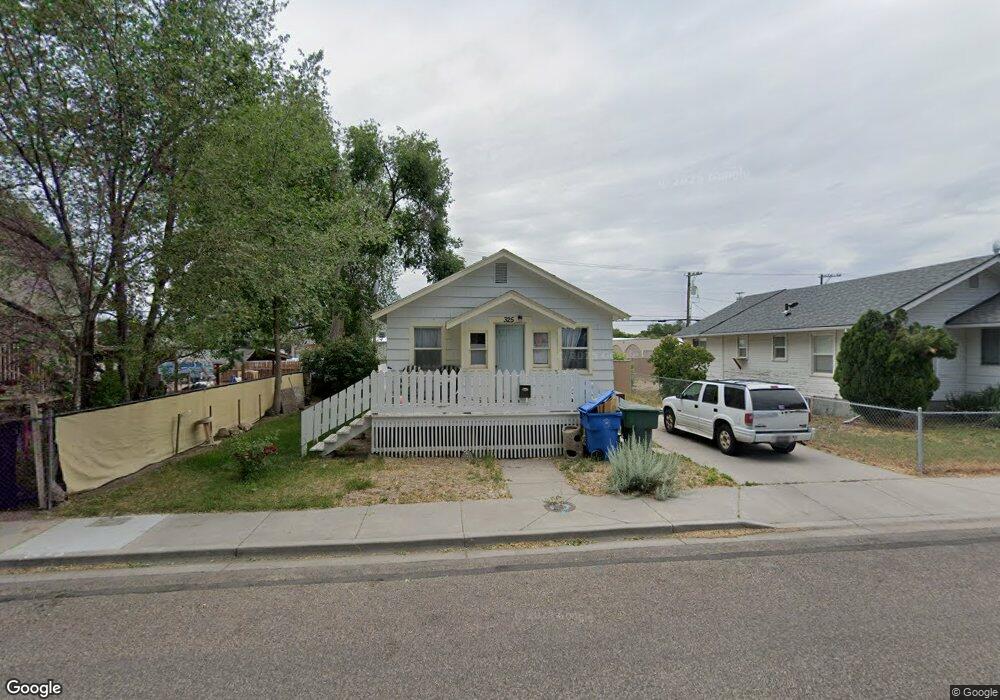
325 Pershing Ave Pocatello, ID 83201
Downtown Pocatello NeighborhoodEstimated Value: $197,000 - $236,945
2
Beds
1
Bath
1,210
Sq Ft
$178/Sq Ft
Est. Value
About This Home
This home is located at 325 Pershing Ave, Pocatello, ID 83201 and is currently estimated at $215,648, approximately $178 per square foot. 325 Pershing Ave is a home located in Bannock County with nearby schools including Lewis & Clark Elementary School, Kinport Academy, and Century High School.
Ownership History
Date
Name
Owned For
Owner Type
Purchase Details
Closed on
Oct 14, 2022
Sold by
Estrada Roberta
Bought by
Jones Lee Ann Graham
Current Estimated Value
Purchase Details
Closed on
Dec 10, 2018
Sold by
Jones John
Bought by
Graham Jones Lee Ann
Purchase Details
Closed on
Dec 4, 2018
Sold by
Jones Penelope
Bought by
Graham Jones Lee Ann
Purchase Details
Closed on
Nov 14, 2018
Sold by
Murrietta Ernie
Bought by
Jones Lee Ann Graham
Create a Home Valuation Report for This Property
The Home Valuation Report is an in-depth analysis detailing your home's value as well as a comparison with similar homes in the area
Home Values in the Area
Average Home Value in this Area
Purchase History
| Date | Buyer | Sale Price | Title Company |
|---|---|---|---|
| Jones Lee Ann Graham | -- | -- | |
| Graham Jones Lee Ann | -- | None Available | |
| Graham Jones Lee Ann | -- | None Available | |
| Jones Lee Ann Graham | -- | None Available | |
| Jones Lee Ann Graham | -- | None Available |
Source: Public Records
Tax History
| Year | Tax Paid | Tax Assessment Tax Assessment Total Assessment is a certain percentage of the fair market value that is determined by local assessors to be the total taxable value of land and additions on the property. | Land | Improvement |
|---|---|---|---|---|
| 2025 | $167 | $187,213 | $55,000 | $132,213 |
| 2024 | $283 | $164,610 | $55,000 | $109,610 |
| 2023 | $1,174 | $183,266 | $55,000 | $128,266 |
| 2022 | $929 | $139,853 | $42,000 | $97,853 |
| 2021 | $1,210 | $139,853 | $42,000 | $97,853 |
| 2020 | $757 | $92,481 | $18,150 | $74,331 |
| 2019 | $1,086 | $109,531 | $25,047 | $84,484 |
| 2018 | $1,978 | $88,554 | $18,150 | $70,404 |
| 2017 | $1,963 | $88,554 | $18,150 | $70,404 |
| 2016 | $1,947 | $88,554 | $18,150 | $70,404 |
| 2015 | $1,003 | $0 | $0 | $0 |
| 2012 | -- | $83,977 | $18,500 | $65,477 |
Source: Public Records
Map
Nearby Homes
- 270 Taft Ave
- 335 Willard Ave
- 172 Taft Ave
- 315 E Pine St
- 402 Mckinley Ave
- 507 Willard Ave
- 166 Washington Ave
- 129 Wayne Ave
- 1028 N 9th Ave
- 168 Park Ave
- 946 N 9th Ave
- 238 Randolph Ave
- 725 E Pine St
- 553 Mckinley Ave
- 855 E Walnut St
- TBD E Elm St
- Lot 19 Block 2 E Elm St
- 674 W Pine St
- 743 Washington Ave
- 682 Randolph Ave
- 331 Pershing Ave
- 168 E Maple St
- 180 E Maple St
- 164 E Maple St
- 349 Pershing Ave
- 344 Yellowstone Ave
- 350 Yellowstone Ave
- 360 Pershing Ave
- 360 Yellowstone Ave
- 296 Pershing Ave
- 345 Yellowstone Ave Unit D-1
- 345 Yellowstone Ave
- 345 Yellowstone Ave Unit STE D2
- 345 Yellowstone Ave Unit STE A
- 345 Yellowstone Ave Unit STE
- 386 Pershing Ave
- 345 Ste. D-1 Yellowstone
- 264 Pershing Ave
- 394 Pershing Ave
- 293 Warren Ave
Your Personal Tour Guide
Ask me questions while you tour the home.