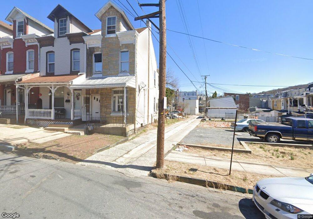
325 S 17th St Reading, PA 19602
District 8 NeighborhoodEstimated Value: $130,000 - $143,774
4
Beds
1
Bath
1,394
Sq Ft
$99/Sq Ft
Est. Value
About This Home
This home is located at 325 S 17th St, Reading, PA 19602 and is currently estimated at $137,925, approximately $98 per square foot. 325 S 17th St is a home located in Berks County with nearby schools including 16th & Haak Elementary School, Central Middle School, and Reading Senior High School.
Ownership History
Date
Name
Owned For
Owner Type
Purchase Details
Closed on
Apr 21, 2023
Sold by
Cyphers Darlene
Bought by
Mnpw Llc
Current Estimated Value
Purchase Details
Closed on
Jun 12, 2017
Sold by
Ellingsworth Doris E
Bought by
Ellingsworth Doris E and Cyphers Darlene L
Purchase Details
Closed on
Jul 17, 1997
Bought by
Ellingsworth Doris E
Create a Home Valuation Report for This Property
The Home Valuation Report is an in-depth analysis detailing your home's value as well as a comparison with similar homes in the area
Home Values in the Area
Average Home Value in this Area
Purchase History
| Date | Buyer | Sale Price | Title Company |
|---|---|---|---|
| Mnpw Llc | $55,000 | None Listed On Document | |
| Ellingsworth Doris E | -- | None Available | |
| Ellingsworth Doris E | $39,000 | -- |
Source: Public Records
Tax History Compared to Growth
Tax History
| Year | Tax Paid | Tax Assessment Tax Assessment Total Assessment is a certain percentage of the fair market value that is determined by local assessors to be the total taxable value of land and additions on the property. | Land | Improvement |
|---|---|---|---|---|
| 2025 | $1,148 | $42,300 | $17,500 | $24,800 |
| 2024 | $1,878 | $42,300 | $17,500 | $24,800 |
| 2023 | $1,849 | $42,300 | $17,500 | $24,800 |
| 2022 | $1,849 | $42,300 | $17,500 | $24,800 |
| 2021 | $1,849 | $42,300 | $17,500 | $24,800 |
| 2020 | $1,831 | $42,300 | $17,500 | $24,800 |
| 2019 | $1,831 | $42,300 | $17,500 | $24,800 |
| 2018 | $1,831 | $42,300 | $17,500 | $24,800 |
| 2017 | $1,819 | $42,300 | $17,500 | $24,800 |
| 2016 | $1,039 | $42,300 | $17,500 | $24,800 |
| 2015 | $1,039 | $42,300 | $17,500 | $24,800 |
| 2014 | $956 | $42,300 | $17,500 | $24,800 |
Source: Public Records
Map
Nearby Homes
- 1711 Perkiomen Ave
- 330 S 17 1/2 St
- 314 S 17th St
- 1725 Cotton St
- 1642 Muhlenberg St
- 1653 Cotton St
- 1634 Muhlenberg St
- 520 S 17 1/2 St
- 629 - 633 S 18th St
- 1849 Perkiomen Ave
- 1535 Haak St
- 1512 Haak St
- 1536 Mineral Spring Rd
- 634 S 16 1 2 St
- 1901 Fairview St
- 1361 Perkiomen Ave
- 1396 Perkiomen Ave
- 1410 Cotton St
- 1969 Fairview Ave
- 549 S 14th St
- 323 S 17th St
- 321 S 17th St
- 319 S 17th St
- 1705 Perkiomen Ave
- 1703 Perkiomen Ave
- 1707 Perkiomen Ave
- 1709 Perkiomen Ave
- 317 S 17th St
- 1711A Perkiomen Ave
- 315 S 17th St
- 1713 Perkiomen Ave
- 313 S 17th St
- 332 S 17 1/2 St
- 1715 Perkiomen Ave
- 328 S 17 1/2 St
- 334 S 17 1/2 St
- 326 S 17 1/2 St
- 311 S 17th St Unit House
- 311 S 17th St
- 1717 Perkiomen Ave