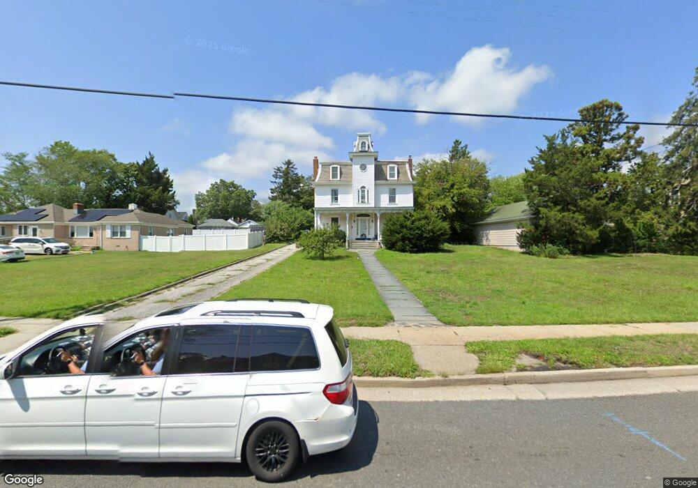
325 S Shore Rd Absecon, NJ 08201
Estimated Value: $417,798 - $445,000
4
Beds
2
Baths
3,817
Sq Ft
$114/Sq Ft
Est. Value
About This Home
This home is located at 325 S Shore Rd, Absecon, NJ 08201 and is currently estimated at $433,950, approximately $113 per square foot. 325 S Shore Rd is a home located in Atlantic County with nearby schools including H. Ashton Marsh Elementary School, Emma C. Attales Middle School, and Life Point Academy/ Life Point Church.
Ownership History
Date
Name
Owned For
Owner Type
Purchase Details
Closed on
Oct 20, 2017
Sold by
Bristyow Edgar C
Bought by
Yacarrino Jospeh and Calaviler Racheal
Current Estimated Value
Purchase Details
Closed on
Aug 10, 2017
Sold by
Bristow Edgar C
Bought by
Yacarrino Joseph Frank and Cavileer Rachel Ann
Home Financials for this Owner
Home Financials are based on the most recent Mortgage that was taken out on this home.
Original Mortgage
$152,192
Interest Rate
5.12%
Mortgage Type
FHA
Create a Home Valuation Report for This Property
The Home Valuation Report is an in-depth analysis detailing your home's value as well as a comparison with similar homes in the area
Home Values in the Area
Average Home Value in this Area
Purchase History
| Date | Buyer | Sale Price | Title Company |
|---|---|---|---|
| Yacarrino Jospeh | -- | None Available | |
| Yacarrino Joseph Frank | $155,000 | None Available |
Source: Public Records
Mortgage History
| Date | Status | Borrower | Loan Amount |
|---|---|---|---|
| Previous Owner | Yacarrino Joseph Frank | $152,192 |
Source: Public Records
Tax History
| Year | Tax Paid | Tax Assessment Tax Assessment Total Assessment is a certain percentage of the fair market value that is determined by local assessors to be the total taxable value of land and additions on the property. | Land | Improvement |
|---|---|---|---|---|
| 2025 | $5,789 | $173,000 | $110,000 | $63,000 |
| 2024 | $5,789 | $173,000 | $110,000 | $63,000 |
| 2023 | $5,719 | $173,000 | $110,000 | $63,000 |
| 2022 | $5,719 | $173,000 | $110,000 | $63,000 |
| 2021 | $5,702 | $173,000 | $110,000 | $63,000 |
| 2020 | $5,712 | $173,000 | $110,000 | $63,000 |
| 2019 | $5,671 | $173,000 | $110,000 | $63,000 |
| 2018 | $7,223 | $219,400 | $111,000 | $108,400 |
| 2017 | $7,170 | $219,400 | $111,000 | $108,400 |
| 2016 | $8,874 | $279,400 | $111,000 | $168,400 |
| 2015 | $8,759 | $279,400 | $111,000 | $168,400 |
| 2014 | $8,639 | $279,400 | $111,000 | $168,400 |
Source: Public Records
Map
Nearby Homes
- 15 W Bolton Ave
- 36 E Lee Ave
- 40 N Shore Rd
- 107 W Church St
- 194 N Shore Rd
- 1416 N Main St
- 1508 7th Ave
- 1513 Ocean Ave
- 1403 N Franklin Blvd
- 1427 Ocean Ave
- 4 Oyster Bay Rd Unit 4M
- 4 Oyster Bay Rd Unit 4K
- 4 Oyster Bay Rd Unit C
- 720 S New Rd Unit 2M
- 720 S New Rd Unit 5H
- 720 S New Rd Unit 5B
- 10 Oyster Bay Rd Unit H
- 202 Burning Tree Blvd
- 19 Oyster Bay Rd Unit G
- 399 Pitney Rd
Your Personal Tour Guide
Ask me questions while you tour the home.