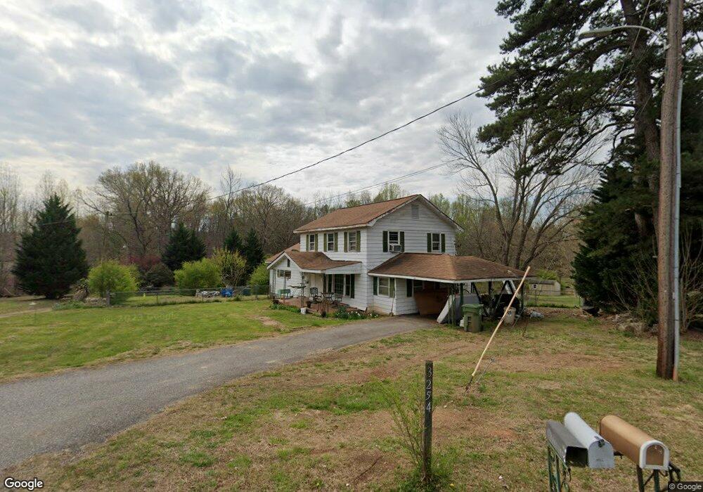
3254 Hipp Rd Iron Station, NC 28080
Estimated Value: $281,000 - $453,000
4
Beds
3
Baths
1,887
Sq Ft
$174/Sq Ft
Est. Value
About This Home
This home is located at 3254 Hipp Rd, Iron Station, NC 28080 and is currently estimated at $329,127, approximately $174 per square foot. 3254 Hipp Rd is a home located in Lincoln County with nearby schools including Iron Station Elementary School, East Lincoln Middle School, and East Lincoln High School.
Ownership History
Date
Name
Owned For
Owner Type
Purchase Details
Closed on
Dec 18, 2007
Sold by
Caudle Louis Wayne
Bought by
Sturgill Dean A
Current Estimated Value
Home Financials for this Owner
Home Financials are based on the most recent Mortgage that was taken out on this home.
Original Mortgage
$88,224
Outstanding Balance
$55,408
Interest Rate
6.15%
Mortgage Type
FHA
Estimated Equity
$273,720
Purchase Details
Closed on
Sep 2, 1998
Bought by
Caudle Louis Wayne and Reba Estel
Create a Home Valuation Report for This Property
The Home Valuation Report is an in-depth analysis detailing your home's value as well as a comparison with similar homes in the area
Home Values in the Area
Average Home Value in this Area
Purchase History
| Date | Buyer | Sale Price | Title Company |
|---|---|---|---|
| Sturgill Dean A | $89,500 | None Available | |
| Caudle Louis Wayne | $86,900 | -- |
Source: Public Records
Mortgage History
| Date | Status | Borrower | Loan Amount |
|---|---|---|---|
| Open | Sturgill Dean A | $88,224 |
Source: Public Records
Tax History Compared to Growth
Tax History
| Year | Tax Paid | Tax Assessment Tax Assessment Total Assessment is a certain percentage of the fair market value that is determined by local assessors to be the total taxable value of land and additions on the property. | Land | Improvement |
|---|---|---|---|---|
| 2025 | $1,168 | $166,122 | $35,892 | $130,230 |
| 2024 | $1,148 | $166,122 | $35,892 | $130,230 |
| 2023 | $1,121 | $166,122 | $35,892 | $130,230 |
| 2022 | $900 | $106,765 | $29,121 | $77,644 |
| 2021 | $900 | $106,765 | $29,121 | $77,644 |
| 2020 | $764 | $106,765 | $29,121 | $77,644 |
| 2019 | $764 | $106,765 | $29,121 | $77,644 |
| 2018 | $852 | $103,180 | $25,851 | $77,329 |
| 2017 | $751 | $103,180 | $25,851 | $77,329 |
| 2016 | $751 | $103,180 | $25,851 | $77,329 |
| 2015 | $822 | $103,180 | $25,851 | $77,329 |
| 2014 | $866 | $110,662 | $26,303 | $84,359 |
Source: Public Records
Map
Nearby Homes
- 222 Oakhill St
- 6 Hager Mountain Ln
- 4394 Mountain Creek Rd
- 4859 Paysour Pond Rd
- 4435 Cornett Dr
- 5486 E Highway 27
- 121 Alexis Forest Dr
- 3960 Orchard Rd
- 1279 Craig Dr
- 3388 Rhyne Forest Rd
- 713 Alexis Lucia Rd
- 0001 Mayberry Rd
- 3323 Sadler Rd
- 1049 Ramsey St
- 1371 Alexis High Shoals Rd
- 1987 & 1981 Magnolia Grove Rd
- 1481 Depot St
- 1789 Doe Ct
- 1554 Forum Ln
- 1785 Doe Ct
- 3262 Hipp Rd
- 3238 Hipp Rd
- 2808 Limestone Ln
- 6413 E Highway 27
- 2985 Long Cir
- 6447 E Highway 27
- 6381 E Highway 27
- 3204 Hipp Rd
- 2957 Long Cir
- 6359 E Highway 27 Hwy
- 3160 Hipp Rd
- 2956 Long Cir
- 2822 Crest Dr
- 6333 E Highway 27
- 2810 Crest Dr
- 2840 Crest Dr
- 2933 Long Cir
- 3224 Cinnabar Ln
- 3234 Cinnabar Ln
- 6491 E Highway 27