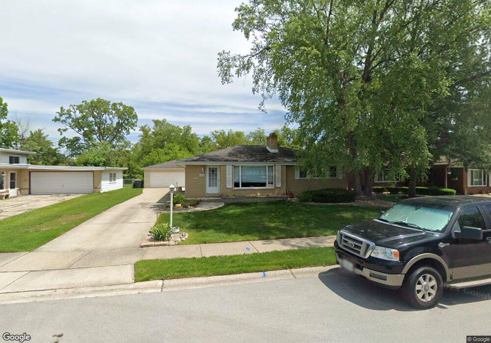
3264 Louise Dr Lansing, IL 60438
Estimated Value: $239,000 - $270,000
3
Beds
2
Baths
1,291
Sq Ft
$195/Sq Ft
Est. Value
About This Home
This home is located at 3264 Louise Dr, Lansing, IL 60438 and is currently estimated at $252,137, approximately $195 per square foot. 3264 Louise Dr is a home located in Cook County with nearby schools including Nathan Hale Elementary School, Heritage Middle School, and Thornton Fractnl So High School.
Ownership History
Date
Name
Owned For
Owner Type
Purchase Details
Closed on
Jun 30, 2005
Sold by
Hayes Nancy I
Bought by
Ruelas Domingo C
Current Estimated Value
Home Financials for this Owner
Home Financials are based on the most recent Mortgage that was taken out on this home.
Original Mortgage
$177,500
Outstanding Balance
$92,777
Interest Rate
5.68%
Mortgage Type
New Conventional
Estimated Equity
$159,360
Purchase Details
Closed on
Jan 13, 2004
Sold by
Mackenzie Hayes Nancy and Hayes Nancy I
Bought by
Hayes Nancy I and Nancy I Hayes Trust
Create a Home Valuation Report for This Property
The Home Valuation Report is an in-depth analysis detailing your home's value as well as a comparison with similar homes in the area
Home Values in the Area
Average Home Value in this Area
Purchase History
| Date | Buyer | Sale Price | Title Company |
|---|---|---|---|
| Ruelas Domingo C | $177,500 | Pntn | |
| Hayes Nancy I | -- | -- |
Source: Public Records
Mortgage History
| Date | Status | Borrower | Loan Amount |
|---|---|---|---|
| Open | Ruelas Domingo C | $177,500 |
Source: Public Records
Tax History Compared to Growth
Tax History
| Year | Tax Paid | Tax Assessment Tax Assessment Total Assessment is a certain percentage of the fair market value that is determined by local assessors to be the total taxable value of land and additions on the property. | Land | Improvement |
|---|---|---|---|---|
| 2024 | $7,182 | $20,151 | $4,016 | $16,135 |
| 2023 | $5,602 | $20,151 | $4,016 | $16,135 |
| 2022 | $5,602 | $12,963 | $3,544 | $9,419 |
| 2021 | $5,450 | $12,962 | $3,543 | $9,419 |
| 2020 | $5,222 | $12,962 | $3,543 | $9,419 |
| 2019 | $6,091 | $15,210 | $3,307 | $11,903 |
| 2018 | $5,921 | $15,210 | $3,307 | $11,903 |
| 2017 | $5,826 | $15,210 | $3,307 | $11,903 |
| 2016 | $4,644 | $12,185 | $3,071 | $9,114 |
| 2015 | $4,442 | $12,185 | $3,071 | $9,114 |
| 2014 | $5,997 | $13,217 | $3,071 | $10,146 |
| 2013 | $5,652 | $13,729 | $3,071 | $10,658 |
Source: Public Records
Map
Nearby Homes
- 18855 Burnham Ave Unit 234
- 18855 Burnham Ave Unit 132
- 18855 Burnham Ave Unit 231
- 3240 N Manor Dr Unit 130
- 3225 Otto St
- 18828 Greenbay Ave
- 18864 Greenbay Ave
- 3363 S Manor Dr
- 18747 Sherman St
- 3109 190th St Unit 2
- 3461 S Manor Dr
- 3320 191st St
- 18905 Park Ave
- 3034 190th St
- 2950 188th Place
- 3251 N Schultz Dr
- 19205 Ada St
- 18602 Chicago Ave
- 19202 Sherman St
- 3312 192nd Place
- 3258 Louise Dr
- 3304 Louise Dr
- 3252 Louise Dr
- 3310 Louise Dr
- 3255 Louise Dr
- 3259 Louise Dr
- 3316 Louise Dr
- 3246 Louise Dr
- 3247 Louise Dr
- 3323 188th St
- 3261 Louise Ct
- 18837 W Louise Dr
- 3322 Louise Dr
- 3319 Louise Ct
- 18766 Walter St
- 18845 W Louise Dr
- 18845 W Louise Dr
- 18845 W Louise Dr
- 3331 188th St
- 3259 Airport Dr