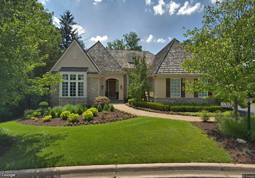
32657 Brookwood Ln Franklin, MI 48025
Estimated Value: $1,442,000 - $1,775,000
3
Beds
5
Baths
3,757
Sq Ft
$438/Sq Ft
Est. Value
About This Home
This home is located at 32657 Brookwood Ln, Franklin, MI 48025 and is currently estimated at $1,647,302, approximately $438 per square foot. 32657 Brookwood Ln is a home located in Oakland County with nearby schools including Wylie E. Groves High School, West Maple Elementary School, and Berkshire Middle School.
Ownership History
Date
Name
Owned For
Owner Type
Purchase Details
Closed on
Oct 21, 2019
Sold by
Gershenson Dennis and Gershenson Nancy
Bought by
Gershenson Dennis and Gershenson Nancy
Current Estimated Value
Purchase Details
Closed on
Feb 9, 2005
Sold by
Robertson Franklin Llc
Bought by
Gershenson Dennis E and Gershenson Nancy
Purchase Details
Closed on
May 15, 2002
Sold by
Kahn William L
Bought by
Robertson Franklin Llc
Create a Home Valuation Report for This Property
The Home Valuation Report is an in-depth analysis detailing your home's value as well as a comparison with similar homes in the area
Home Values in the Area
Average Home Value in this Area
Purchase History
| Date | Buyer | Sale Price | Title Company |
|---|---|---|---|
| Gershenson Dennis | -- | None Available | |
| Gershenson Dennis E | -- | Metropolitan Title Company | |
| Robertson Franklin Llc | $237,500 | -- |
Source: Public Records
Tax History Compared to Growth
Tax History
| Year | Tax Paid | Tax Assessment Tax Assessment Total Assessment is a certain percentage of the fair market value that is determined by local assessors to be the total taxable value of land and additions on the property. | Land | Improvement |
|---|---|---|---|---|
| 2024 | $13,957 | $724,550 | $0 | $0 |
| 2023 | $13,233 | $688,800 | $0 | $0 |
| 2022 | $14,321 | $687,870 | $0 | $0 |
| 2021 | $14,261 | $685,970 | $0 | $0 |
| 2020 | $12,169 | $665,150 | $0 | $0 |
| 2019 | $11,087 | $648,140 | $0 | $0 |
| 2018 | $14,371 | $612,640 | $0 | $0 |
| 2017 | $14,564 | $612,640 | $0 | $0 |
| 2016 | $13,446 | $586,080 | $0 | $0 |
| 2015 | -- | $590,980 | $0 | $0 |
| 2014 | -- | $589,050 | $0 | $0 |
| 2011 | -- | $432,210 | $0 | $0 |
Source: Public Records
Map
Nearby Homes
- 32696 Ravine Dr
- 25690 W 14 Mile Rd
- 25635 River Dr
- 32890 Whatley Rd
- 4428 Old Trinity Ct
- 4647 Private Lake Dr
- 26565 Scenic Hwy
- 26075 Woodlore Rd
- 26377 Willowgreen Dr
- 7100 Wing Lake Rd
- 25325 Devon Ln
- 27170 W 14 Mile Rd
- 31050 Briarcliff Rd
- 24924 Riverwood Dr
- 25265 Canterbury Rd
- 6940 Wing Lake Rd
- 24459 Bloomington Ct
- 7371 Lindenmere Dr
- 6940 Castle Dr
- 7005 Cathedral Dr
- 32679 Brookwood Ln Unit 14
- 32613 Brookwood Ln
- 32691 Brookwood Ln
- 32541 Woodcreek Ct
- 32715 Brookwood Ln
- 32662 Brookwood Ln
- 32556 Woodcreek Ct
- 32556 Woodcreek Ct Unit 8
- 32737 Brookwood Ln
- 32684 Brookwood Ln
- 32539 Woodcreek Ct
- 32539 Woodcreek Ct Unit 10
- 32684 Ravine Dr
- 26068 German Mill Rd
- 32748 Brookwood Ln
- 32748 Brookwood Ln Unit 5
- 32714 Ravine Dr
- 32708 Ravine Dr Unit 13
- 32706 Ravine Dr
- 32704 Ravine Dr Unit 11