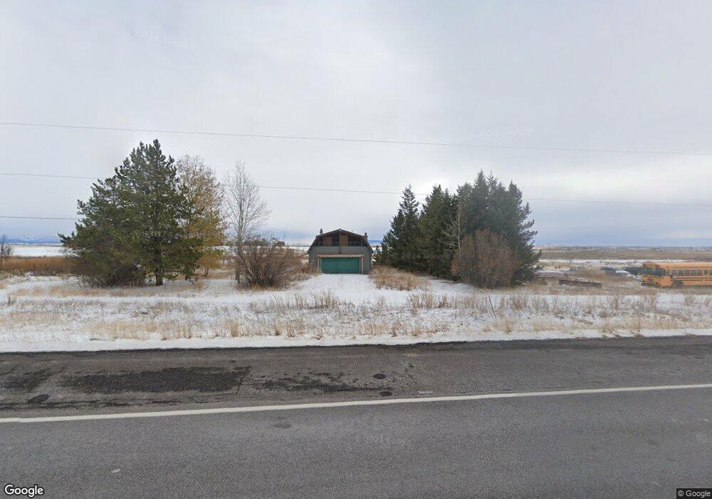
3266 Highway 20 Ashton, ID 83420
Estimated Value: $138,102 - $574,000
4
Beds
2
Baths
2,212
Sq Ft
$167/Sq Ft
Est. Value
About This Home
This home is located at 3266 Highway 20, Ashton, ID 83420 and is currently estimated at $370,034, approximately $167 per square foot. 3266 Highway 20 is a home located in Fremont County with nearby schools including Ashton Elementary School and North Fremont Junior/Senior High School.
Ownership History
Date
Name
Owned For
Owner Type
Purchase Details
Closed on
Jul 7, 2012
Sold by
Lyon Jack M and Lyon Cecilia Anne
Bought by
Lyon Jack M and Lyon Cecilia Anne
Current Estimated Value
Purchase Details
Closed on
Aug 25, 2011
Sold by
Deutsche Bank National Trust Company
Bought by
Lyon Jack M and Lyon Cecilia Anne
Home Financials for this Owner
Home Financials are based on the most recent Mortgage that was taken out on this home.
Original Mortgage
$47,339
Outstanding Balance
$33,231
Interest Rate
4.87%
Mortgage Type
Adjustable Rate Mortgage/ARM
Estimated Equity
$336,803
Create a Home Valuation Report for This Property
The Home Valuation Report is an in-depth analysis detailing your home's value as well as a comparison with similar homes in the area
Home Values in the Area
Average Home Value in this Area
Purchase History
| Date | Buyer | Sale Price | Title Company |
|---|---|---|---|
| Lyon Jack M | -- | None Available | |
| Lyon Jack M | -- | -- |
Source: Public Records
Mortgage History
| Date | Status | Borrower | Loan Amount |
|---|---|---|---|
| Open | Lyon Jack M | $47,339 |
Source: Public Records
Tax History Compared to Growth
Tax History
| Year | Tax Paid | Tax Assessment Tax Assessment Total Assessment is a certain percentage of the fair market value that is determined by local assessors to be the total taxable value of land and additions on the property. | Land | Improvement |
|---|---|---|---|---|
| 2025 | $195 | $0 | $0 | $0 |
| 2024 | $195 | $0 | $0 | $0 |
| 2023 | $195 | $0 | $0 | $0 |
| 2022 | $0 | $0 | $0 | $0 |
| 2021 | $195 | $0 | $0 | $0 |
| 2020 | $1,589 | $168,814 | $27,000 | $141,814 |
| 2019 | $1,549 | $166,064 | $24,250 | $141,814 |
| 2018 | $911 | $82,826 | $24,250 | $58,576 |
| 2017 | $10 | $79,976 | $23,523 | $56,453 |
| 2016 | $991 | $79,976 | $23,523 | $56,453 |
| 2015 | $977 | $155,429 | $0 | $0 |
| 2014 | $874 | $92,327 | $0 | $0 |
| 2013 | $874 | $95,247 | $0 | $0 |
Source: Public Records
Map
Nearby Homes
- 3355 E 1000 Rd N
- SW 5 Ac E 875 N
- SE 5 Ac E 875 N
- 950 N 3400 E
- 3541 850 N
- 3154 Falls Crossing Place
- 3158 Falls Crossing Place
- 3060 River Side Dr
- 750 N 3100 E
- 3537 Fall River Rd
- 951 N 3600 E
- 3017 E 750 N
- 706 N 3000 E
- 650 N 3725 E
- 1387 Cedar Lake Ln
- 3660 E 1100 N
- L2 BLK 1 E 1300 Rd N
- L5 BLK 2 Ice Tong Ln
- L2 BLK 2 Ice Tong Ln
- 417 Main St