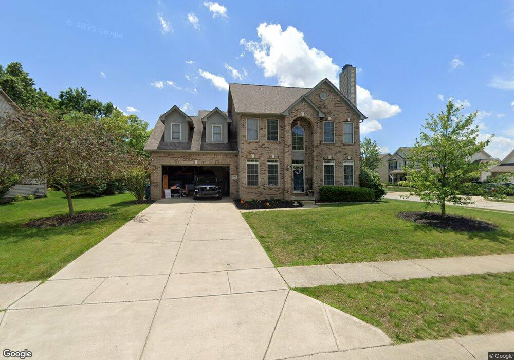
3269 Amber Way Bargersville, IN 46106
Estimated Value: $431,000 - $526,000
3
Beds
3
Baths
2,626
Sq Ft
$178/Sq Ft
Est. Value
About This Home
This home is located at 3269 Amber Way, Bargersville, IN 46106 and is currently estimated at $466,531, approximately $177 per square foot. 3269 Amber Way is a home located in Johnson County with nearby schools including Maple Grove Elementary School, Center Grove Middle School Central, and Center Grove High School.
Ownership History
Date
Name
Owned For
Owner Type
Purchase Details
Closed on
Aug 30, 2005
Sold by
Princeton Group Inc
Bought by
Mcleish Ii Richard C and Mcleish Melissa M
Current Estimated Value
Home Financials for this Owner
Home Financials are based on the most recent Mortgage that was taken out on this home.
Original Mortgage
$44,000
Interest Rate
5.93%
Mortgage Type
Future Advance Clause Open End Mortgage
Create a Home Valuation Report for This Property
The Home Valuation Report is an in-depth analysis detailing your home's value as well as a comparison with similar homes in the area
Home Values in the Area
Average Home Value in this Area
Purchase History
| Date | Buyer | Sale Price | Title Company |
|---|---|---|---|
| Mcleish Ii Richard C | -- | None Available |
Source: Public Records
Mortgage History
| Date | Status | Borrower | Loan Amount |
|---|---|---|---|
| Previous Owner | Mcleish Ii Richard C | $44,000 |
Source: Public Records
Tax History Compared to Growth
Tax History
| Year | Tax Paid | Tax Assessment Tax Assessment Total Assessment is a certain percentage of the fair market value that is determined by local assessors to be the total taxable value of land and additions on the property. | Land | Improvement |
|---|---|---|---|---|
| 2025 | $3,870 | $417,300 | $86,700 | $330,600 |
| 2024 | $3,870 | $387,000 | $86,700 | $300,300 |
| 2023 | $3,722 | $372,200 | $86,700 | $285,500 |
| 2022 | $3,471 | $347,100 | $73,200 | $273,900 |
| 2021 | $2,898 | $289,800 | $57,100 | $232,700 |
| 2020 | $2,806 | $280,600 | $57,100 | $223,500 |
| 2019 | $2,710 | $271,000 | $57,100 | $213,900 |
| 2018 | $2,750 | $269,400 | $57,100 | $212,300 |
| 2017 | $2,805 | $280,500 | $47,300 | $233,200 |
| 2016 | $2,374 | $255,100 | $47,300 | $207,800 |
| 2014 | $2,403 | $233,800 | $47,300 | $186,500 |
| 2013 | $2,403 | $240,300 | $47,300 | $193,000 |
Source: Public Records
Map
Nearby Homes
- 3270 Cherokee Cir
- 3301 Cheyenne Ct
- 3176 Tecumseh Way
- 3058 Mcintosh Dr
- 5571 Auburndale Dr
- 000 N State Road 135
- 4000 N State Road 135
- 5502 Breaburn Rd
- 6093 Tremont Blvd
- 3808 Claybrook Ct
- 3372 Clary Boulevard Dr S
- 3762 Woodruff Place
- Bellamy Plan at Lone Pine Farms
- Henley Plan at Lone Pine Farms
- Chatham Plan at Lone Pine Farms
- Harmony Plan at Lone Pine Farms
- Freeport Plan at Lone Pine Farms
- Stamford Plan at Lone Pine Farms
- 6451 Enclave Ct
- 6491 Enclave Blvd
- 5757 Cherokee Ct
- 5780 Cherokee Ct
- 3225 Amber Way
- 3268 Amber Way
- 5745 Cherokee Ct
- 3256 Amber Way
- 5756 Cherokee Ct
- 3244 Amber Way
- 3209 Amber Way
- 5792 Cherokee Ct
- 5744 Cherokee Ct
- 3232 Amber Way
- 5733 Cherokee Ct
- 4046 Pitscottie Ct
- 3197 Amber Way
- 5789 Somerset Blvd
- 5792 Cherokee Dr
- 3220 Amber Way
- 5777 Somerset Blvd
- 5810 Cherokee Dr