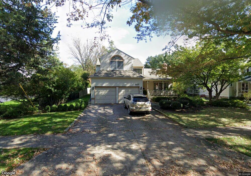
327 Chestnut St Moorestown, NJ 08057
Estimated Value: $953,081 - $1,017,000
--
Bed
--
Bath
3,081
Sq Ft
$323/Sq Ft
Est. Value
About This Home
This home is located at 327 Chestnut St, Moorestown, NJ 08057 and is currently estimated at $995,020, approximately $322 per square foot. 327 Chestnut St is a home located in Burlington County with nearby schools including South Valley Elementary School, Moorestown Upper Elementary School, and William Allen Middle School.
Ownership History
Date
Name
Owned For
Owner Type
Purchase Details
Closed on
Jul 1, 2008
Sold by
Basara Stanley E and Basara Claire T
Bought by
Todd Christopher and Todd Leslie
Current Estimated Value
Home Financials for this Owner
Home Financials are based on the most recent Mortgage that was taken out on this home.
Original Mortgage
$211,000
Outstanding Balance
$138,381
Interest Rate
6.4%
Mortgage Type
Stand Alone First
Estimated Equity
$856,639
Purchase Details
Closed on
Aug 27, 1993
Sold by
Colyer William
Bought by
Basara Stanley and Basara Clare
Home Financials for this Owner
Home Financials are based on the most recent Mortgage that was taken out on this home.
Original Mortgage
$200,000
Interest Rate
7.16%
Create a Home Valuation Report for This Property
The Home Valuation Report is an in-depth analysis detailing your home's value as well as a comparison with similar homes in the area
Home Values in the Area
Average Home Value in this Area
Purchase History
| Date | Buyer | Sale Price | Title Company |
|---|---|---|---|
| Todd Christopher | $611,000 | Group 21 Title Agency | |
| Basara Stanley | $307,500 | -- |
Source: Public Records
Mortgage History
| Date | Status | Borrower | Loan Amount |
|---|---|---|---|
| Open | Todd Christopher | $211,000 | |
| Previous Owner | Basara Stanley | $200,000 |
Source: Public Records
Tax History Compared to Growth
Tax History
| Year | Tax Paid | Tax Assessment Tax Assessment Total Assessment is a certain percentage of the fair market value that is determined by local assessors to be the total taxable value of land and additions on the property. | Land | Improvement |
|---|---|---|---|---|
| 2025 | $14,341 | $505,500 | $185,000 | $320,500 |
| 2024 | $13,906 | $505,500 | $185,000 | $320,500 |
| 2023 | $13,906 | $505,500 | $185,000 | $320,500 |
| 2022 | $13,765 | $505,500 | $185,000 | $320,500 |
| 2021 | $13,583 | $505,500 | $185,000 | $320,500 |
| 2020 | $13,497 | $505,500 | $185,000 | $320,500 |
| 2019 | $13,259 | $505,500 | $185,000 | $320,500 |
| 2018 | $12,900 | $505,500 | $185,000 | $320,500 |
| 2017 | $13,012 | $505,500 | $185,000 | $320,500 |
| 2016 | $12,966 | $505,500 | $185,000 | $320,500 |
| 2015 | $12,809 | $505,500 | $185,000 | $320,500 |
| 2014 | $12,162 | $505,500 | $185,000 | $320,500 |
Source: Public Records
Map
Nearby Homes
- 205 E Central Ave
- 308 Elm St
- 133 Plum St Unit 6
- 80 E 3rd St
- 82 E 3rd St
- 66 E 3rd St
- 50 E 3rd St
- 15 E 2nd St
- 408 E 2nd St
- 514 E Main St
- 744 Signal Light Rd
- 129 S Church St
- 863 Golf View Rd
- 526 E Main St
- 11 E Sutton Ave
- 4 E Sutton Ave
- 4 W Close
- 310 S Washington Ave
- 493 N Church St
- 633 E Main St Unit B7
- 325 Chestnut St
- 200 E Central Ave
- 209 Linden St
- 210 E Central Ave
- 319 Chestnut St
- 219 Linden St
- 330 Chestnut St
- 326 Chestnut St
- 140 E Central Ave
- 214 E Central Ave
- 229 Linden St
- 218 Linden St
- 322 Chestnut St
- 315 Chestnut St
- 320 Chestnut St
- 222 Linden St
- 316 Chestnut St
- 233 Linden St
- 220 E Central Ave
- 309 Chestnut St