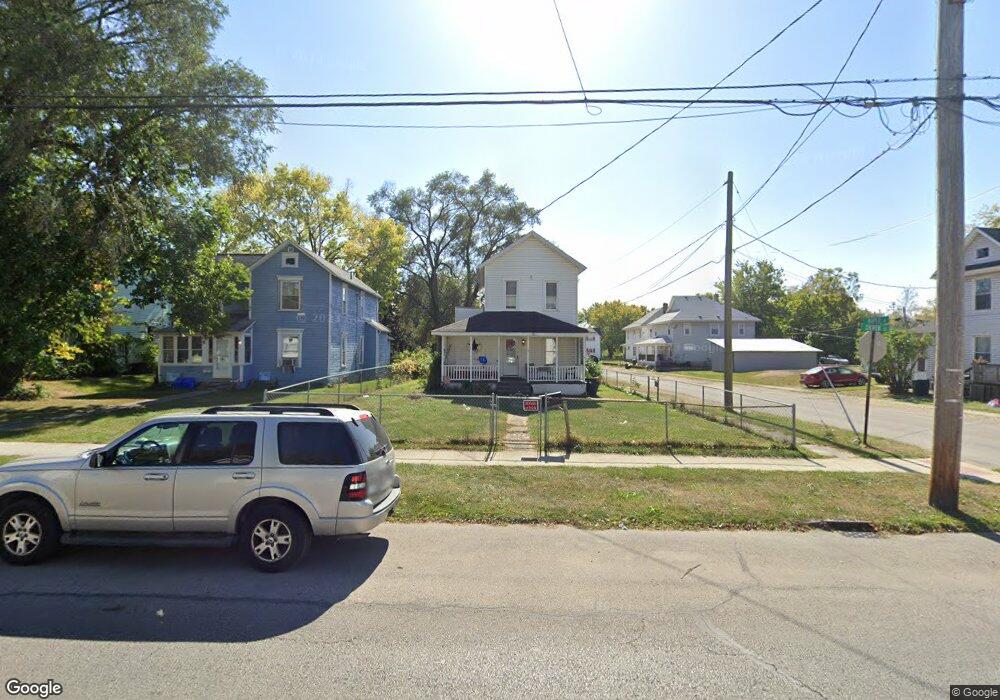
327 Silver St Marion, OH 43302
Estimated Value: $96,000 - $130,000
2
Beds
2
Baths
1,632
Sq Ft
$65/Sq Ft
Est. Value
About This Home
This home is located at 327 Silver St, Marion, OH 43302 and is currently estimated at $105,725, approximately $64 per square foot. 327 Silver St is a home located in Marion County with nearby schools including Rutherford B. Hayes Elementary School, Ulysses S. Grant Middle School, and Harding High School.
Ownership History
Date
Name
Owned For
Owner Type
Purchase Details
Closed on
Mar 11, 2014
Bought by
Keen Joshua L and Surv Jennifer L
Current Estimated Value
Purchase Details
Closed on
Mar 8, 2005
Sold by
Mcclain Lawrence M
Bought by
Keen Joshua L
Home Financials for this Owner
Home Financials are based on the most recent Mortgage that was taken out on this home.
Original Mortgage
$47,040
Interest Rate
5.67%
Mortgage Type
FHA
Purchase Details
Closed on
Oct 15, 1992
Bought by
Keen Joshua L and Surv Jennifer L
Create a Home Valuation Report for This Property
The Home Valuation Report is an in-depth analysis detailing your home's value as well as a comparison with similar homes in the area
Home Values in the Area
Average Home Value in this Area
Purchase History
| Date | Buyer | Sale Price | Title Company |
|---|---|---|---|
| Keen Joshua L | -- | -- | |
| Keen Joshua L | $48,000 | Evergreen Title Agency Ltd | |
| Keen Joshua L | $27,000 | -- |
Source: Public Records
Mortgage History
| Date | Status | Borrower | Loan Amount |
|---|---|---|---|
| Previous Owner | Keen Joshua L | $47,040 |
Source: Public Records
Tax History
| Year | Tax Paid | Tax Assessment Tax Assessment Total Assessment is a certain percentage of the fair market value that is determined by local assessors to be the total taxable value of land and additions on the property. | Land | Improvement |
|---|---|---|---|---|
| 2025 | $867 | $26,910 | $1,640 | $25,270 |
| 2024 | $867 | $22,570 | $1,580 | $20,990 |
| 2023 | $867 | $22,570 | $1,580 | $20,990 |
| 2022 | $805 | $22,570 | $1,580 | $20,990 |
| 2021 | $694 | $17,520 | $1,370 | $16,150 |
| 2020 | $696 | $17,520 | $1,370 | $16,150 |
| 2019 | $677 | $17,520 | $1,370 | $16,150 |
| 2018 | $722 | $18,720 | $1,340 | $17,380 |
| 2017 | $1,025 | $18,720 | $1,340 | $17,380 |
| 2016 | $727 | $18,720 | $1,340 | $17,380 |
| 2015 | $728 | $18,350 | $1,280 | $17,070 |
| 2014 | $742 | $18,350 | $1,280 | $17,070 |
| 2012 | $838 | $20,950 | $1,360 | $19,590 |
Source: Public Records
Map
Nearby Homes
- 343 Commercial St
- 178 Leader St
- 324 W Church St
- 138 Park Blvd
- 532 N Prospect St
- 531 N Main St
- 552 N Prospect St
- 434 N State St
- 230 Edwards St
- 405 Toledo Ave
- 374 Nunin Ct
- 245 Park Blvd
- 212 Short St
- 321 W Columbia St
- 302 Blaine Ave
- 641 Blake Ave
- 229 W Columbia St
- 313 Windsor St
- 348 Cherry St
- 347 Blaine Ave
- 321 Silver St
- 317 Silver St
- 341 Silver 341 1/2 St
- 291 Maple St
- 347 Silver St
- 289 Maple St Unit 291
- 307 Silver St
- 328 Chestnut St
- 318 Chestnut St
- 353 Silver St
- 318 Chestnut St
- 314 Chestnut St
- 340 Chestnut St Unit 342
- 310 Chestnut St
- 289-291 289 Maple St
- 328 Silver St
- 322 Silver St
- 357 Silver St
- 314 Silver St(p)
- 342 Silver St
Your Personal Tour Guide
Ask me questions while you tour the home.