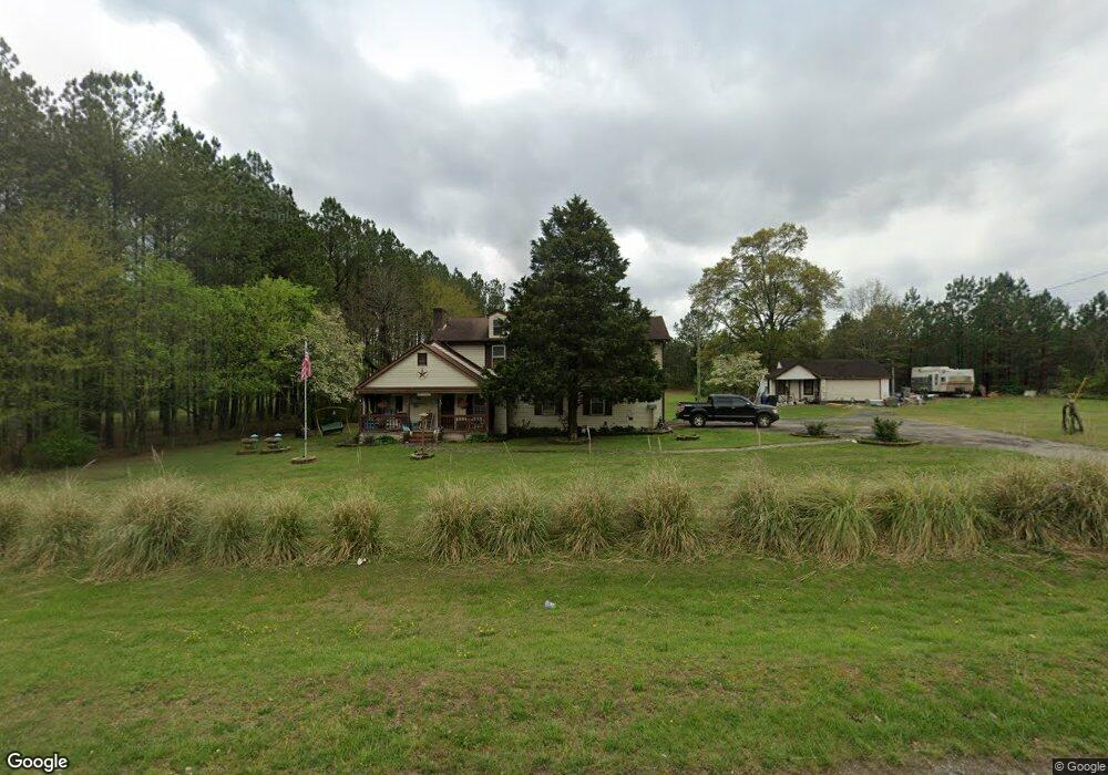
3277 Cedartown Hwy Rockmart, GA 30153
Estimated Value: $253,000 - $313,000
3
Beds
2
Baths
2,343
Sq Ft
$121/Sq Ft
Est. Value
About This Home
This home is located at 3277 Cedartown Hwy, Rockmart, GA 30153 and is currently estimated at $283,704, approximately $121 per square foot. 3277 Cedartown Hwy is a home located in Polk County with nearby schools including Rockmart Middle School.
Ownership History
Date
Name
Owned For
Owner Type
Purchase Details
Closed on
Jul 26, 2007
Sold by
Not Provided
Bought by
Malone Timothy I
Current Estimated Value
Purchase Details
Closed on
May 4, 1999
Sold by
Malone Timothy I
Bought by
Malone Agnes G
Purchase Details
Closed on
Apr 1, 1982
Sold by
Malone Curtis L
Bought by
Malone Timothy L
Purchase Details
Closed on
Jun 1, 1980
Sold by
Malone Curtis and Malone
Bought by
Malone Curtis L
Purchase Details
Closed on
Oct 9, 1976
Sold by
Malone D P
Bought by
Malone Curtis and Malone
Purchase Details
Closed on
Oct 5, 1942
Bought by
Malone D P
Create a Home Valuation Report for This Property
The Home Valuation Report is an in-depth analysis detailing your home's value as well as a comparison with similar homes in the area
Home Values in the Area
Average Home Value in this Area
Purchase History
| Date | Buyer | Sale Price | Title Company |
|---|---|---|---|
| Malone Timothy I | -- | -- | |
| Malone Agnes G | $69,000 | -- | |
| Malone Timothy L | -- | -- | |
| Malone Curtis L | -- | -- | |
| Malone Curtis | -- | -- | |
| Malone D P | -- | -- |
Source: Public Records
Tax History Compared to Growth
Tax History
| Year | Tax Paid | Tax Assessment Tax Assessment Total Assessment is a certain percentage of the fair market value that is determined by local assessors to be the total taxable value of land and additions on the property. | Land | Improvement |
|---|---|---|---|---|
| 2024 | $2,112 | $101,037 | $3,329 | $97,708 |
| 2023 | $1,578 | $66,502 | $3,329 | $63,173 |
| 2022 | $1,347 | $56,765 | $2,219 | $54,546 |
| 2021 | $1,365 | $56,765 | $2,219 | $54,546 |
| 2020 | $1,367 | $56,765 | $2,219 | $54,546 |
| 2019 | $1,146 | $42,657 | $2,219 | $40,438 |
| 2018 | $1,113 | $40,383 | $2,219 | $38,164 |
| 2017 | $1,099 | $40,383 | $2,219 | $38,164 |
| 2016 | $1,081 | $39,724 | $1,560 | $38,164 |
| 2015 | $1,094 | $40,072 | $1,560 | $38,512 |
| 2014 | $1,102 | $40,072 | $1,560 | $38,512 |
Source: Public Records
Map
Nearby Homes
- 0 Bethlehem Rd Unit 10622470
- 2020 Old Cedartown Rd
- 1907 Old Cedartown Rd
- 3825 Rockmart Hwy
- 2056 Bellview Rd
- 0 Pine Mountain Rd Unit 7662185
- 482 Pine Mountain Rd
- 0 Pine Mountain Rd Unit 10478395
- 0 Pine Mountain Rd Unit 7540784
- 1157 Stringer Rd
- 394 Knight Rd
- 65 Wheeler Rd
- 93 Clay Rd
- 1039 Old Cedartown Rd
- 1211 Bellview Rd
- 440 Mcbride Rd
- 332 Stringer Rd
- 600 Grady Rd
- 0 Richard Pullen Rd Unit 7626794
- 0 Richard Pullen Rd Unit 10577442
- 3317 Cedartown Hwy
- 3253 Cedartown Hwy
- 3225 Cedartown Hwy
- 3326 Cedartown Hwy
- 101 Rockmart Hwy
- 0 Rockmart Hwy Unit 7040698
- 3260 Cedartown Hwy
- 3254 Cedartown Hwy
- 108 Barber Rd
- 3208 Cedartown Hwy
- 178 Sardis Rd
- 1.5 Bethlehem Church Rd
- 6 Bethlehem Rd
- 5 Bethlehem Rd
- 3 Bethlehem Rd
- 8 Bethlehem Rd
- 9 Bethlehem Rd
- 13 Bethlehem Rd
- 11 Bethlehem Rd
- 10 Bethlehem Rd