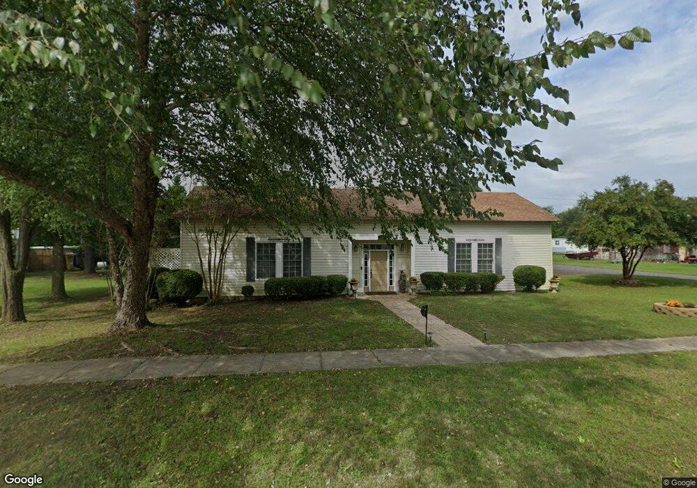
328 King St Port Royal, VA 22535
Estimated Value: $233,240 - $298,000
2
Beds
2
Baths
1,172
Sq Ft
$232/Sq Ft
Est. Value
About This Home
This home is located at 328 King St, Port Royal, VA 22535 and is currently estimated at $271,560, approximately $231 per square foot. 328 King St is a home located in Caroline County with nearby schools including Caroline Middle School and Caroline High School.
Ownership History
Date
Name
Owned For
Owner Type
Purchase Details
Closed on
Aug 25, 2016
Sold by
Chenault Rick Dean and Chenault Monica Gabrielle
Bought by
Chenault Rick Dean and Chenault Monica Gabrielle
Current Estimated Value
Home Financials for this Owner
Home Financials are based on the most recent Mortgage that was taken out on this home.
Original Mortgage
$75,000
Outstanding Balance
$59,946
Interest Rate
3.45%
Mortgage Type
New Conventional
Estimated Equity
$211,614
Purchase Details
Closed on
May 5, 2010
Sold by
Motley Vivian F
Bought by
Chenault Rick D
Create a Home Valuation Report for This Property
The Home Valuation Report is an in-depth analysis detailing your home's value as well as a comparison with similar homes in the area
Home Values in the Area
Average Home Value in this Area
Purchase History
| Date | Buyer | Sale Price | Title Company |
|---|---|---|---|
| Chenault Rick Dean | -- | Fidelity National Title | |
| Chenault Rick D | $70,000 | None Available |
Source: Public Records
Mortgage History
| Date | Status | Borrower | Loan Amount |
|---|---|---|---|
| Open | Chenault Rick Dean | $75,000 |
Source: Public Records
Tax History Compared to Growth
Tax History
| Year | Tax Paid | Tax Assessment Tax Assessment Total Assessment is a certain percentage of the fair market value that is determined by local assessors to be the total taxable value of land and additions on the property. | Land | Improvement |
|---|---|---|---|---|
| 2025 | $148,009 | $192,220 | $45,000 | $147,220 |
| 2024 | $1,328 | $172,500 | $42,000 | $130,500 |
| 2023 | $1,367 | $177,500 | $42,000 | $135,500 |
| 2022 | $1,367 | $177,500 | $42,000 | $135,500 |
| 2021 | $1,367 | $177,500 | $42,000 | $135,500 |
| 2020 | $1,282 | $154,500 | $36,000 | $118,500 |
| 2019 | $1,003 | $154,500 | $36,000 | $118,500 |
| 2018 | $1,282 | $154,500 | $36,000 | $118,500 |
| 2017 | $1,282 | $154,500 | $36,000 | $118,500 |
| 2016 | $1,267 | $154,500 | $36,000 | $118,500 |
| 2015 | $1,074 | $149,200 | $36,000 | $113,200 |
| 2014 | $1,074 | $149,200 | $36,000 | $113,200 |
Source: Public Records
Map
Nearby Homes
- 0 & 00 King St
- 517 King St
- 17392 Cherwood Pond Ln
- 23348 Tidewater Trail
- 14405 Millbank Rd
- 14264 Millbank Rd
- 15617 Mockingbird Ln
- 0 Goose Point Ct Unit VACV2006706
- 11418 Jersey Rd
- Lot 27 Salem Church Rd
- Lot 26 Salem Church Rd
- Lot 6 Salem Church Rd
- Lot 15 Salem Church Rd
- Lot 14 Salem Church Rd
- Lot 19 Salem Church Rd
- Lot 4 Salem Church Rd
- Lot 16 Salem Church Rd
- Lot 7 Salem Church Rd
- Lot 8 Salem Church Rd
- Lot 17 Salem Church Rd