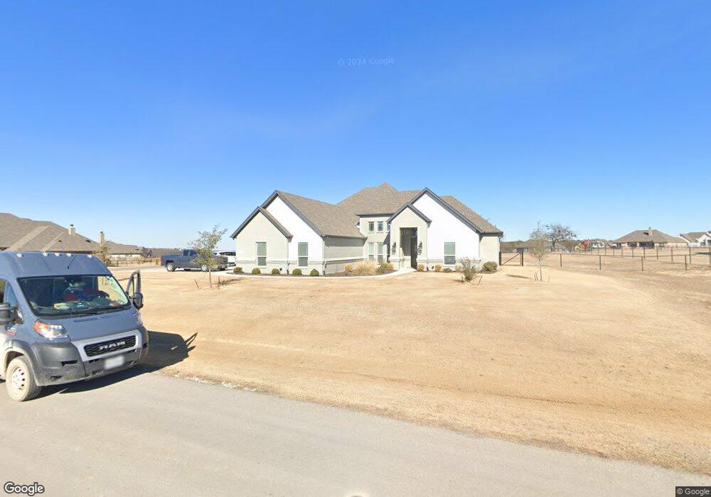
328 Palo Alto Dr Springtown, TX 76082
Estimated Value: $561,000 - $630,000
3
Beds
3
Baths
2,493
Sq Ft
$237/Sq Ft
Est. Value
About This Home
This home is located at 328 Palo Alto Dr, Springtown, TX 76082 and is currently estimated at $590,063, approximately $236 per square foot. 328 Palo Alto Dr is a home located in Parker County with nearby schools including Goshen Creek Elementary School, Springtown Middle School, and Springtown Intermediate School.
Ownership History
Date
Name
Owned For
Owner Type
Purchase Details
Closed on
Sep 22, 2022
Sold by
Anderson Bushman Charles
Bought by
Charles A And Lana K Bushman Revocable Trust
Current Estimated Value
Purchase Details
Closed on
May 2, 2019
Sold by
Heid Construction Llc
Bought by
Bushman Charles A and Bushman Lana K
Home Financials for this Owner
Home Financials are based on the most recent Mortgage that was taken out on this home.
Original Mortgage
$157,000
Interest Rate
4.2%
Mortgage Type
New Conventional
Create a Home Valuation Report for This Property
The Home Valuation Report is an in-depth analysis detailing your home's value as well as a comparison with similar homes in the area
Home Values in the Area
Average Home Value in this Area
Purchase History
| Date | Buyer | Sale Price | Title Company |
|---|---|---|---|
| Charles A And Lana K Bushman Revocable Trust | -- | -- | |
| Bushman Charles A | -- | Providence Title Company |
Source: Public Records
Mortgage History
| Date | Status | Borrower | Loan Amount |
|---|---|---|---|
| Previous Owner | Bushman Charles A | $157,000 |
Source: Public Records
Tax History Compared to Growth
Tax History
| Year | Tax Paid | Tax Assessment Tax Assessment Total Assessment is a certain percentage of the fair market value that is determined by local assessors to be the total taxable value of land and additions on the property. | Land | Improvement |
|---|---|---|---|---|
| 2025 | $6,723 | $544,900 | -- | -- |
| 2024 | $6,723 | $495,364 | -- | -- |
| 2023 | $6,723 | $414,240 | $0 | $0 |
| 2022 | $6,715 | $376,590 | $50,000 | $326,590 |
| 2021 | $7,289 | $376,590 | $50,000 | $326,590 |
| 2020 | $6,633 | $343,800 | $40,000 | $303,800 |
| 2019 | $7,130 | $343,800 | $40,000 | $303,800 |
| 2018 | $416 | $20,000 | $20,000 | $0 |
| 2017 | $436 | $20,000 | $20,000 | $0 |
Source: Public Records
Map
Nearby Homes
- 317 Palo Alto Dr
- 124 Stanford Ln
- 235 Columbia Ct
- 223 Columbia Ct
- 252 Harvard Ln
- 391 Red Bird Dr
- 363 Red Bird Dr
- 447 Red Bird Dr
- 2801 Agnes Cir
- 105 Kathy Stephens Ave
- 340 Sanger Dr
- 408 Herb Stephens Jr Way
- TBD Candis Ct
- 104 Candis Ct
- 650 Sanger Dr
- 1038 Colt Rd
- 1097 Colt Rd
- 1094 Colt Rd
- The Jackson Plan at Taylor Ranch
- The Aylin Plan at Taylor Ranch
- 324 Palo Alto Dr
- 345 Palo Alto Dr
- 264 Columbia Ct
- 332 Palo Alto Dr
- 329 Palo Alto Dr
- 325 Palo Alto Dr
- 320 Palo Alto Dr
- 268 Columbia Ct
- 2538-2860 Agnes Cir
- 255 Columbia Ct
- 269 Columbia Ct
- 139 Stanford Ln
- 135 Stanford Ln
- 333 Palo Alto Dr
- 131 Stanford Ln
- 337 Palo Alto Dr
- 143 Stanford Ln
- 251 Columbia Ct
- 273 Columbia Ct
- 272 Columbia Ct