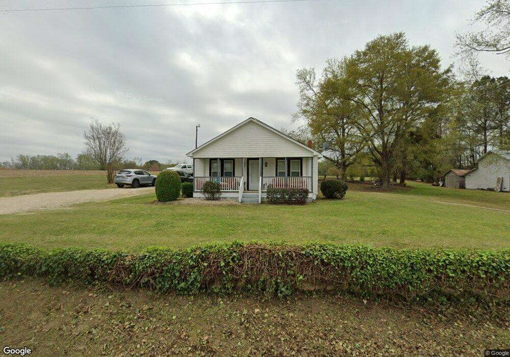
3280 Benson Rd Angier, NC 27501
Estimated Value: $200,000 - $212,711
2
Beds
1
Bath
1,015
Sq Ft
$202/Sq Ft
Est. Value
About This Home
This home is located at 3280 Benson Rd, Angier, NC 27501 and is currently estimated at $204,928, approximately $201 per square foot. 3280 Benson Rd is a home located in Harnett County with nearby schools including Angier Elementary School, North Harnett Primary School, and Harnett Central Middle School.
Ownership History
Date
Name
Owned For
Owner Type
Purchase Details
Closed on
Apr 9, 2013
Sold by
Lee Jean Adams
Bought by
Hockaday Christopher Edison and Hockaday Regina Lasater
Current Estimated Value
Home Financials for this Owner
Home Financials are based on the most recent Mortgage that was taken out on this home.
Original Mortgage
$62,000
Outstanding Balance
$13,228
Interest Rate
3.65%
Mortgage Type
Future Advance Clause Open End Mortgage
Estimated Equity
$191,700
Create a Home Valuation Report for This Property
The Home Valuation Report is an in-depth analysis detailing your home's value as well as a comparison with similar homes in the area
Home Values in the Area
Average Home Value in this Area
Purchase History
| Date | Buyer | Sale Price | Title Company |
|---|---|---|---|
| Hockaday Christopher Edison | $62,000 | None Available |
Source: Public Records
Mortgage History
| Date | Status | Borrower | Loan Amount |
|---|---|---|---|
| Open | Hockaday Christopher Edison | $62,000 |
Source: Public Records
Tax History Compared to Growth
Tax History
| Year | Tax Paid | Tax Assessment Tax Assessment Total Assessment is a certain percentage of the fair market value that is determined by local assessors to be the total taxable value of land and additions on the property. | Land | Improvement |
|---|---|---|---|---|
| 2025 | $931 | $127,064 | $0 | $0 |
| 2024 | $944 | $127,064 | $0 | $0 |
| 2023 | $931 | $127,064 | $0 | $0 |
| 2022 | $612 | $170,139 | $0 | $0 |
| 2021 | $612 | $64,280 | $0 | $0 |
| 2020 | $612 | $64,280 | $0 | $0 |
| 2019 | $597 | $64,280 | $0 | $0 |
| 2018 | $597 | $64,280 | $0 | $0 |
| 2017 | $597 | $64,280 | $0 | $0 |
| 2016 | $458 | $47,280 | $0 | $0 |
| 2015 | $458 | $47,280 | $0 | $0 |
| 2014 | $458 | $47,280 | $0 | $0 |
Source: Public Records
Map
Nearby Homes
- 73 Stone Apiary Dr
- 238 Harvester Rd
- SEBASTIAN Plan at Tobacco Road
- KAYLEEN Plan at Tobacco Road
- VANDERBURGH Plan at Tobacco Road
- PARKETTE Plan at Tobacco Road
- FINLEY Plan at Tobacco Road
- ALTON Plan at Tobacco Road
- MEADOW Plan at Tobacco Road
- HAVEN II Plan at Tobacco Road
- 243 Harvester Rd
- The Magnolia A Plan at Tobacco Road
- The Willow E Plan at Tobacco Road
- The Ash D Plan at Tobacco Road
- Birch II A Plan at Tobacco Road
- The Cypress II Plan at Tobacco Road
- The Crawford Plan at Tobacco Road
- The Hickory II C Plan at Tobacco Road
- 239 Harvester Rd
- 223 Harvester Rd
- 3355 Benson Rd
- 3366 Benson Rd
- 3188 Benson Rd
- 3479 Benson Rd
- 3512 Benson Rd
- 238 Harvester Rd Unit 5
- 159 Camellia Rd
- 3041 Benson Rd
- 0 Camellia Rd Unit B TR1867064
- 0 Camellia Rd Unit C TR1867066
- 0 Camellia Rd Unit B 1867064
- 0 Creekcrest Ct Unit 1892241
- 0 Creekcrest Ct Unit 1892232
- 0 Creekcrest Ct Unit 405334
- 0 Creekcrest Ct Unit 405335
- 2996 Benson Rd
- 2989 Benson Rd
- 3581 Benson Rd
- 60 Harvester Rd Unit 36896936
- 60 Harvester Rd Unit 36896913