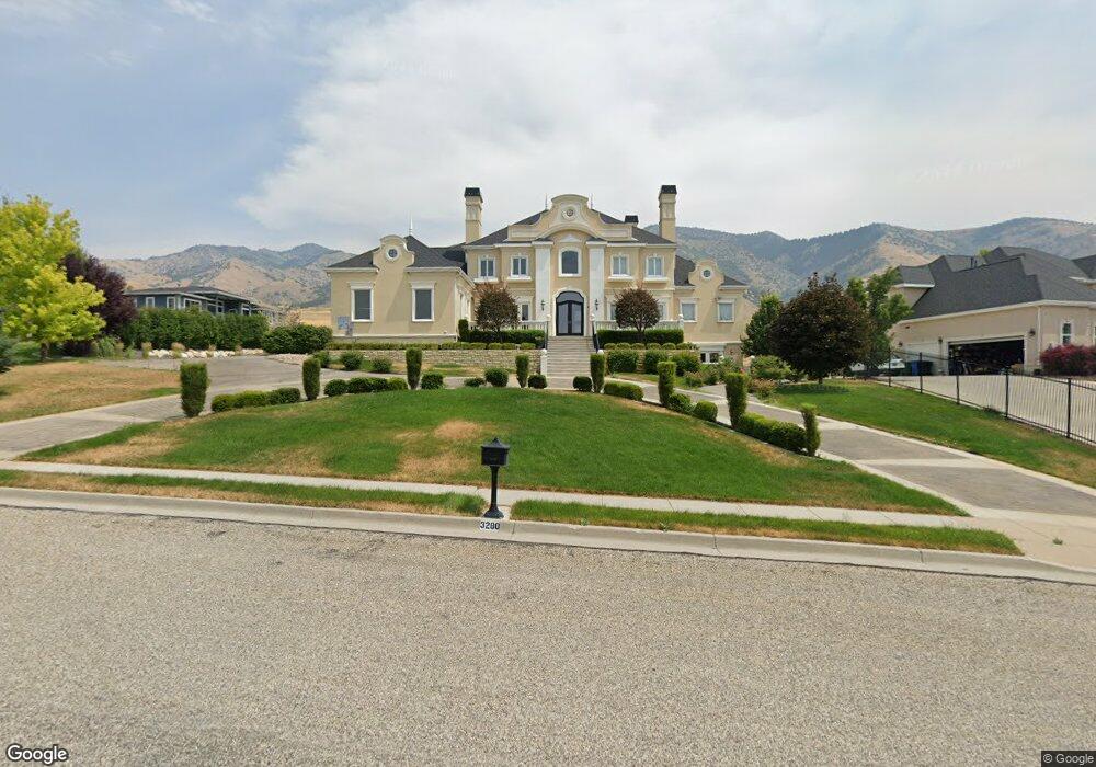
3280 N 1950 E North Logan, UT 84341
Estimated Value: $1,785,049 - $2,471,000
6
Beds
8
Baths
11,721
Sq Ft
$189/Sq Ft
Est. Value
About This Home
This home is located at 3280 N 1950 E, North Logan, UT 84341 and is currently estimated at $2,216,762, approximately $189 per square foot. 3280 N 1950 E is a home located in Cache County with nearby schools including Greenville School, Cedar Ridge School, and North Cache Middle School.
Ownership History
Date
Name
Owned For
Owner Type
Purchase Details
Closed on
Dec 27, 2021
Sold by
Thornock Justin and Thornock Heidi
Bought by
Thornock Vanthornock O and Thornock Shari L
Current Estimated Value
Home Financials for this Owner
Home Financials are based on the most recent Mortgage that was taken out on this home.
Original Mortgage
$590,000
Outstanding Balance
$541,455
Interest Rate
3.1%
Estimated Equity
$1,675,307
Purchase Details
Closed on
Dec 11, 2021
Sold by
Thornock Vanthornock O and Thornock Shari
Bought by
Hornock Justin T and Hornock Heidi
Home Financials for this Owner
Home Financials are based on the most recent Mortgage that was taken out on this home.
Original Mortgage
$590,000
Outstanding Balance
$541,455
Interest Rate
3.1%
Estimated Equity
$1,675,307
Purchase Details
Closed on
May 12, 2021
Sold by
Morth Logan Holdings Properties Llc
Bought by
Thornock O Van O and Thornock Shari
Purchase Details
Closed on
Jul 22, 2010
Sold by
Morrison Gerry and Morrison Colleen
Bought by
North Logan Property Holdings Llc
Purchase Details
Closed on
Mar 26, 2007
Sold by
Cook Lori
Bought by
Morrison Gerry and Morrison Colleen
Purchase Details
Closed on
Mar 9, 2002
Sold by
Cook Albert P and Cook Lori
Bought by
Cook Albert P and Cook Lori
Purchase Details
Closed on
Jan 29, 2001
Sold by
Nyman Family Llc
Bought by
Cook Albert P and Cook Lori
Create a Home Valuation Report for This Property
The Home Valuation Report is an in-depth analysis detailing your home's value as well as a comparison with similar homes in the area
Home Values in the Area
Average Home Value in this Area
Purchase History
| Date | Buyer | Sale Price | Title Company |
|---|---|---|---|
| Thornock Vanthornock O | -- | None Available | |
| Hornock Justin T | -- | None Available | |
| Thornock O Van O | -- | None Available | |
| North Logan Property Holdings Llc | -- | None Available | |
| Morrison Gerry | -- | American Secure Title | |
| Morrison Gerry | -- | American Secure Title | |
| Cook Albert P | -- | Cache Title Company | |
| Cook Albert P | -- | Northern Title Company |
Source: Public Records
Mortgage History
| Date | Status | Borrower | Loan Amount |
|---|---|---|---|
| Open | Hornock Justin T | $590,000 |
Source: Public Records
Tax History
| Year | Tax Paid | Tax Assessment Tax Assessment Total Assessment is a certain percentage of the fair market value that is determined by local assessors to be the total taxable value of land and additions on the property. | Land | Improvement |
|---|---|---|---|---|
| 2025 | $7,920 | $1,108,685 | $0 | $0 |
| 2024 | $9,137 | $1,190,130 | $0 | $0 |
| 2023 | $9,628 | $1,173,630 | $0 | $0 |
| 2022 | $10,077 | $1,173,630 | $0 | $0 |
| 2021 | $10,093 | $1,666,350 | $233,850 | $1,432,500 |
| 2020 | $7,582 | $1,180,019 | $233,850 | $946,169 |
| 2019 | $7,941 | $1,180,018 | $233,850 | $946,168 |
| 2018 | $7,335 | $1,056,391 | $153,075 | $903,316 |
| 2017 | $7,561 | $623,995 | $0 | $0 |
| 2016 | $8,587 | $697,765 | $0 | $0 |
| 2015 | $11,195 | $906,365 | $0 | $0 |
| 2014 | $6,749 | $559,630 | $0 | $0 |
| 2013 | -- | $558,945 | $0 | $0 |
Source: Public Records
Map
Nearby Homes
- 1990 E Canyon Ridge Dr
- 2275 E Meadow Lark Ln N
- 105 E 3100 N
- 2827 E Viewcrest Cir
- 94 S 950 E
- 86 S 950 E
- 108 S 900 E
- 124 N 1140 E
- 1128 E 50 N Unit 81
- 894 E 130 N Unit 17
- 866 E 130 N
- 1154 E 160 N
- 1153 E 160 N
- 108 N 900 E
- 803 E 160 N Unit 1
- 882 E 160 N Unit 4
- 940 E Canyon Rd
- 710 E 100 S
- 116 N 820 E
- 2517 N 2050 E
- 3260 N 1950 E
- 1964 E 3375 N Unit 47
- 1984 E 3375 N Unit 48
- 1950 E 3200 N
- 3280 N 1875 E Unit 27
- 3339 N 1950 E Unit 46
- 3285 N 1950 E
- 3265 N 1950 E Unit 32
- 3265 N 1950 E
- 1985 E 3375 N Unit 49
- 1985 E 3375 N
- 3510 N 1930 E
- 3507 N 1930 E
- 3497 N 1930 E
- 1935 E 3200 N
- 1920 E 3375 N Unit 45
- 3404 N 1930 E
- 1904 E 3375 N Unit 44
- 1904 E 3375 N
- 3408 N 1930 E
Your Personal Tour Guide
Ask me questions while you tour the home.